A mid/upper level low is moving slowly E-NE across the Northern Plains and upper Midwest today per Goes-16 water vapor satellite imagery. Source: https://weather.cod.edu

Seeing a few showers move northeast across southern Minnesota late this Sunday afternoon, a few of these showers could affect parts of northwest Wisconsin tonight.

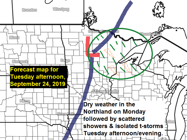
A few strong to severe thunderstorms are possible in parts of the Northland late Tuesday afternoon-evening with a marginal risk of severe thunderstorms covering much of northwest Wisconsin and adjacent areas of eastern Minnesota including Duluth and the I-35 corridor. Note: There is a greater risk of severe weather covering southern Minnesota and western-central portions of Wisconsin for late Tuesday afternoon-evening.


Low temperature forecast for Monday morning, September 23. Source: https://graphical.weather.gov

High temperature forecast for Monday, September 23

Excessive amounts of rain fell Friday into early Saturday morning in northwest Minnesota and eastern North Dakota with another area of heavy rain Saturday in parts of east-central Minnesota and northwest Wisconsin. Source: https://lab.weathermodels.com

24-Hour Rainfall Totals from 9 AM Saturday to 9 AM Sunday, September 21-22, 2019. Source: https://mesowest.utah.edu; https://www.weather.gov/dlh/
- 0.6 SSW Grantsburg, WI: 2.37″
- Lind, WI: 2.21″
- Hayward, WI: 1.66″
- 6.1 SW Pine City, MN: 1.50″
- 1.8 ENE Pine City, MN: 1.35″
- 7.7 W Spooner, WI: 1.13″
- Clam Lake, WI: 0.90″
- Solon Springs, WI: 0.86″
- Minong, WI: 0.86″
- Barnes, WI: 0.64″
- Siren, WI: 0.58″
- Cotton, MN: 0.55″
- Washburn, WI: 0.52″
- Hinckley, MN: 0.50″
- Moose Lake, MN: 0.42″
- Cass Lake, MN: 0.36″
- Ashland, WI: 0.32″
- Grand Marais, MN: 0.30″
- Duluth, MN (Airport) 0.19″
- Superior, WI (Airport) 0.18″
- Saginaw, MN: 0.16″
- Bigfork, MN: 0.14″
- Ely, MN: 0.12″
- Brainerd, MN: 0.09″
- International Falls, MN: 0.07″
- Isabella, MN: 0.05″
- Chisholm-Hibbing, MN: 0.04″
- Grand Rapids, MN: 0.03″
Temperature and Precipitation report for Duluth, Minnesota for September 15-21, 2019.
High Temperatures/Departure from Normal
- 9/15: 74F/+9 degrees above normal
- 9/16: 73F/+8 degrees above normal
- 9/17: 73F/+8 degrees above normal
- 9/18: 80F/+16 degrees above normal
- 9/19: 83F/+19 degrees above normal
- 9/20: 67F/+4 degrees above normal
- 9/21: 75F/+12 degrees above normal
Low Temperatures/Departure from Normal
Note: *=record warm low temperature for the date.
- 9/15: 53F/+7 degrees above normal
- 9/16: 53F/+7 degrees above normal
- 9/17: 57F/+11 degrees above normal
- 9/18: *65F/+20 degrees above normal
- 9/19: 61F/+16 degrees above normal
- 9/20: 58F/+14 degrees above normal
- 9/21: 58F/+14 degrees above normal
Average temperature for the week of September 15: 66.4 degrees; +11.8 degrees above normal. Source: https://www.dnr.state.mn.us
- Total Precipitation: 0.82″
- Normal: 0.99″
- Departure: -0.17″ below normal
State average for Minnesota for the week of September 15, 2019.
- Temperature: 69.4 degrees
- Departure: +11.6 degrees above normal
- Precipitation: 1.23″
- Departure: +0.50″ above normal
Temperature departure map for the week of September 15 — Well above normal temperatures across the Northland last week with departures some 10 to 15 degrees warmer than normal! Source: https://hprcc.unl.edu

Precipitation departure map for the week of September 15 — Last week’s rainfall totals varied quite a bit resulting in some parts of the Northland having above normal rainfall last week (green) well other areas had near to below normal rainfall (yellow) Note: Far northwest Minnesota saw extreme amounts of rain late last week with the purple colors representing rain totals +6 to +8″ above normal, incredible!

Fall foliage is popping across the Northland, and we’re getting closer to when we typically see peak conditions in our area (see map below) Source: https://www.dnr.state.mn.us

Here’s a look at the latest fall color report in Minnesota as of September 22, 2019, and a link to Wisconsin’s fall color report https://www.travelwisconsin.com/fall-color-report

Looks like the Northern Rockies could be getting quite a bit of snow late this week. Won’t be much longer before I’m talking about snow hitting the Northland.
Source: 12z European ensemble model 9.22.19; https://weathermodels.com

…Weather Summary…
Cooler and less humid weather in the Northland today with quite a bit of cloudiness. Sunday afternoon temperatures ranged from the upper 50s to middle 60s, pretty close to normal for September 22.
A few showers are possible in parts of the Northland tonight, otherwise mostly cloudy skies should continue with some breaks in the clouds in spots. Lows will range from the mid 40s to low 50s with west winds.
Mostly sunny to partly cloudy skies are on the way for Monday with highs in the mid 60s to low 70s. Winds will be out of the west/southwest at 10 to 20 mph.
Tuesday starts dry, but scattered showers are expected in the Northland Tuesday afternoon through Wednesday as a cold front moves through the area which will be followed by a pocket of cold temps aloft (-25C H5 temps) on Wednesday. Note: A few thunderstorms are also possible Tuesday afternoon/evening, and again Wednesday afternoon.
Keeping an eye on additional rain chances late this week through next weekend with late Thursday and Friday, and next Sunday looking like the wettest days per model guidance (timing subject to change)
Forecast for Duluth and Superior
.Tonight… Mostly cloudy. Isolated showers possible. Low 50 to 53. Wind west to southwest 5 to 15 mph.
.Monday… Partly cloudy. High 67 to 72. Wind southwest 10 to 15 mph.
.Tuesday… Partly to mostly cloudy. Showers and a thunderstorm possible late. High 71 to 76. Wind southwest 10 to 20 mph.
Normal temperatures for Monday
- High 62
- Low 43
- Sunrise Monday 6:57 AM CDT
- Sunset Monday 7:05 PM CDT
Thanks for reading!
Leave a Reply