Rain chances return to the Northland on Tuesday with scattered showers possible in north-central Minnesota beginning before Noon. Scattered showers spread farther south/east Tuesday afternoon through Tuesday evening. A few thunderstorms are also possible Tuesday afternoon and evening.

Scattered showers along with a few thunderstorms will move across the Northland from about mid-morning Tuesday into Tuesday evening – Here’s the HRRR model radar forecast valid from 7 AM Tuesday to 1 AM Wednesday. Source: https://weathermodels.com

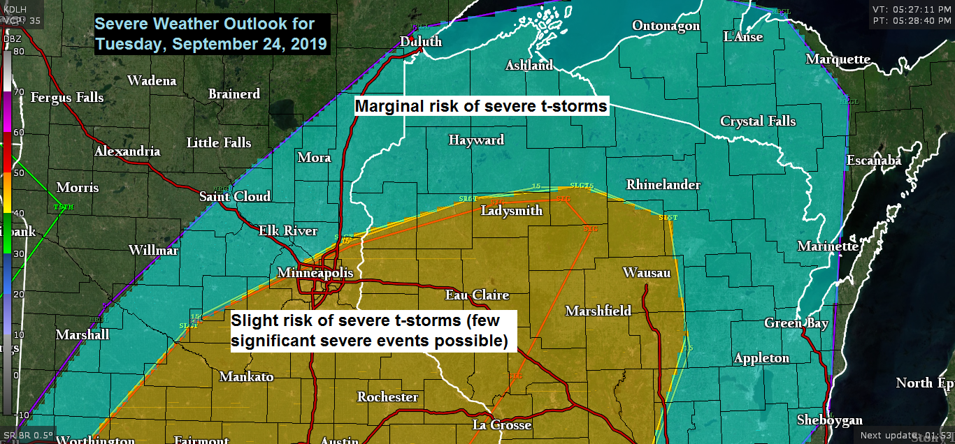
A marginal risk of severe thunderstorms continues Tuesday in northwest Wisconsin into far eastern Minnesota with a greater risk of severe thunderstorms farther south where a few significant severe weather events are possible late Tuesday afternoon/evening.

A potent setup for some severe weather Tuesday afternoon and evening from south-central Minnesota into central Wisconsin.
Source: 18z NAM model; https://www.pivotalweather.com

Low temperature forecast for Tuesday morning, September 24. Source: https://graphical.weather.gov

High temperature forecast for Tuesday, September 24.

An interesting weather day in Arizona today thanks to a strong upper level system which is over the Southern Rockies per Goes-16 water vapor satellite imagery. This system has been producing strong to severe thunderstorms and heavy rain (flash flooding) today in parts of Arizona. Source: https://weather.cod.edu

Radar loop from Monday, September 23, 2019.

That orange blob on the image below indicates an Enhanced risk of severe thunderstorms today, and in all places, Arizona! Interesting. Source: https://kamala.cod.edu/SPC/

The pattern is changing! Shots of cooler, below normal temperatures move into the Northland midweek through this weekend, then we could see a bit of warm up early next week before another shot of below normal temperatures for the middle/end of next week. Meanwhile out west a period of well below normal temperatures are forecast starting late this week and continuing into much of next week the way it looks now (blue and purple colors on map)
Temperature anomaly map below is valid through October 8, 2019.
Source: 12z European ensemble model 9.23.19; https://weathermodels.com

Along with the colder temperatures comes the risk for some accumulating snow in the Northern Rockies this weekend, and there could be quite a bit of snow in that area.

…Weather Summary…
A beautiful first official day of fall 2019 with plentiful sun, light winds with temperatures this Monday afternoon in the upper 60s to low-mid 70s which is above normal for late September. Note: Normal highs in the Northland are mainly in the lower 60s on September 23rd.
Looking at the water vapor satellite imagery late this afternoon shows a mid-upper level low moving east across the central/eastern Great Lakes while a potent upper level trough was over the southwest U.S.; and this system is bringing some severe weather and flooding rains to Arizona today. The next system which will affect the upper Midwest was moving into the Pacific northwest today.
A quiet weather night is on the way under clear to partly cloudy skies. Lows tonight will be in the mid 40s to mid 50s. Southwest winds will continue tonight on the backside of high pressure which will move east out of southern Missouri while an area of low pressure heads northeast into the Northern Plains.
Tuesday morning should be dry in most of the Northland, then will see scattered showers move across the area from Tuesday afternoon into Tuesday night. This rain will be caused by an area of low pressure which will move east-northeast out of North Dakota while a warm front and cold front pass through the area. A decent amount of warm air and moisture advection will occur ahead of this system on Tuesday with dew points climbing into the 50s while northwest Wisconsin could have dew points reaching into the lower 60s. Instability is also forecast to increase during the afternoon-early evening hours with CAPE of around 500-1000 J/kg in eastern Minnesota and northwest Wisconsin along with steepening mid level lapse rates of 7.0-8.0 C/km. Stronger winds aloft including 60-70 knots at 500mb will spread into the upper Midwest on Tuesday with 80-120 knot winds in the upper levels spreading into the Northern Plains and western Minnesota. We should see some thunderstorms develop Tuesday afternoon or evening primarily in northwest Wisconsin as this area will be in the zone of greatest moisture return and best instability, but a few thunderstorms can’t be ruled out farther west into north-central, northeast and eastern Minnesota. Note: There is a risk of a few strong to severe thunderstorms late Tuesday afternoon from far eastern Minnesota into northwest Wisconsin, hail and strong winds are the main hazards from these storms along with downpours and lightning. Highs on Tuesday will be in the 60s and 70s with southwest winds 10 to 20 mph with higher gusts.
Cooler and breezy conditions on Wednesday and will also see a few showers develop during the afternoon-early evening hours thanks to a pocket of cold mid level temps of around -25C which moves over the area. Highs on Wednesday will be in the upper 50s to middle 60s with west winds gusting 20 to around 30 mph.
Thursday looks dry, but rain chances return to the Northland Thursday night into Friday morning as a fast moving low pressure system affects the area.
The period from Friday afternoon into Saturday looks dry as will be in between systems, one exiting to the east while the next one organizes across the Rockies.
Note: Looks like we could be dealing with the first widespread frost of the season Friday night-Saturday morning with potential for widespread lows in the 30s, especially inland from Lake Superior.
Wet weather returns late this weekend into early next week (~September 29-30) as the upper level pattern amplifies with a strong ridge to the S/SE and a strong trough out west. An active southwest flow looks to setup across the Plains and upper Midwest with periods of rainy weather expected late this weekend into early next week.
Forecast for Duluth and Superior
.Tonight… Mostly clear. Low 50 to 55. Wind southwest 5 to 15 mph.
.Tuesday… Breezy. Partly to mostly cloudy. A few showers later in the day. Isolated thunderstorms also possible. High 71 to 76. Wind southwest 10 to 20 mph with gusts to 25 mph.
.Wednesday… Breezy and cooler. Partly to mostly cloudy. A few showers possible mainly in the afternoon. High 61 to 66. Wind west 15 to 30 mph.
Normal temperatures for Tuesday
- High 61
- Low 43
- Sunrise Tuesday 6:58 AM CDT
- Sunset Tuesday 7:03 PM CDT
Thanks for reading!
Leave a Reply