A wet week ahead – Rain chances tonight and Monday, Wednesday-Thursday and on Saturday. Foggy as well, especially tonight and Monday.
Warm front (red line on map below) will lift north out of Iowa tonight into Monday. A strong low level jet will transport warm and humid air north into the upper Midwest while elevated instability also increases from SW-NE tonight, net result from all this is for showers and thunderstorms to become more numerous tonight, lingering into Monday.

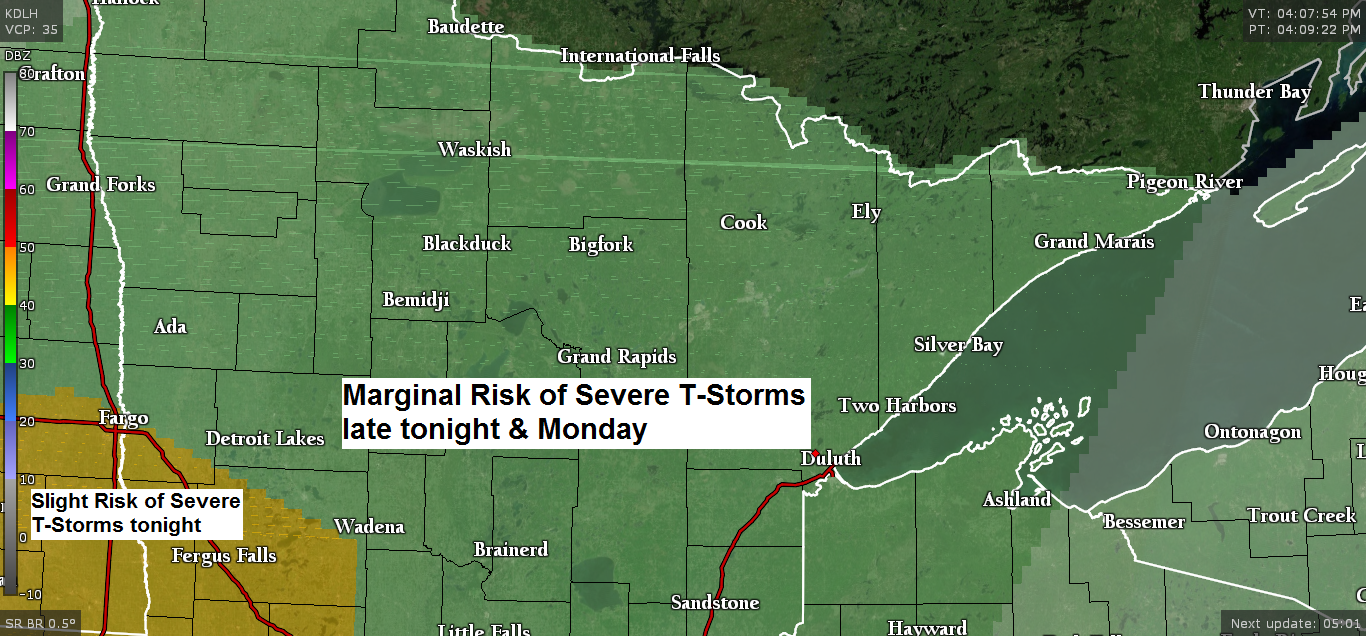
A few strong to severe thunderstorms remain possible over the entire Northland from late tonight into Monday. Hail is the primary threat in the stronger storms.

Sunday afternoon dew points range from the 40s in northeast Minnesota and northwest Wisconsin to the lower 70s in southeast Nebraska. That soupy air mass currently over the Central Plains will lift north into the upper Midwest through Monday. Source: https://www.spc.noaa.gov

18z HRRR model radar forecast valid from 7 PM this evening to 7 PM Monday. Source: https://weather.cod.edu

There is potential for heavy rain and possibly some flooding overnight into Monday morning in parts of the Northland especially if thunderstorms move over the same location for a few hours. Model guidance has been showing a corridor of potentially excessive rainfall amounts setting up near and south of the Highway 2 corridor late tonight into Monday morning.
Source: https://weather.us

A powerful winter storm continues today over the Northern Rockies with a strong upper level low/trough spinning over that area per Goes-16 water vapor satellite imagery. Source: https://weather.cod.edu
Note: Here’s a link to snowfall reports per Great Falls, Montana NWS https://www.wrh.noaa.gov/total_forecast/getprod.php?wfo=tfx&pil=pns&sid=tfx
Link to the latest storm summary from the Weather Prediction Center https://www.wpc.ncep.noaa.gov/discussions/nfdscc5.html

A highly amplified weather pattern will continue the next few days with a strong ridge to the south-southeast and a strong trough to the west, eventually will see the big ridge break down as the trough over the western U.S. pushes east.
Source: 12z European ensemble model 9.28.19; https://www.tropicaltidbits.com/

Here’s what the pattern is forecast to look like by midweek. The ridge breaks down just a bit, but still looks hot over a large portion of the southern and eastern U.S. through midweek while cooler air pushes south and east out of the Northern Rockies. Source: https://www.wpc.ncep.noaa.gov

Low temperature forecast for Monday morning, September 30. Source: https://graphical.weather.gov

High temperature forecast for Monday, September 30

Temperature and Precipitation report for Duluth, Minnesota for September 22-28, 2019
High Temperatures/Departure from Normal
- 9/22: 65F/+3 degrees above normal
- 9/23: 74F/+12 degrees above normal
- 9/24: 77F/+16 degrees above normal
- 9/25: 67F/+6 degrees above normal
- 9/26: 66F/+5 degrees above normal
- 9/27: 61F/+1 degree above normal
- 9/28: 60F/Normal
Low Temperatures/Departure from Normal
- 9/22: 56F/+12 degrees above normal
- 9/23: 50F/+7 degrees above normal
- 9/24: 55F/+12 degrees above normal
- 9/25: 48F/+6 degrees above normal
- 9/26: 40F/-2 degrees below normal
- 9/27: 41F/-1 degree below normal
- 9/28: 37F/-4 degrees below normal
Average temperature for the week of September 22: 56.9 degrees; +5.3 degrees above normal. Source: https://www.dnr.state.mn.us
- Total Precipitation: 0.11″
- Normal: 0.92″
- Departure: -0.81″ below normal
State Average for Minnesota for the week of September 22, 2019. Source: https://www.dnr.state.mn.us
- Average temperature: 58.9 degrees
- Departure: +4.0 degrees above normal
- Precipitation: 0.43″
- Departure: -0.31″ below normal
Temperature departure map for the week of September 22. Source: https://hprcc.unl.edu

Precipitation departure map for the week of September 22.

…Weather Summary…
Fog and drizzle with showers and thunderstorms tonight and Monday. Drying out a bit Tuesday before more rain chances return for midweek.
Low pressure over the western High Plains this Sunday afternoon is forecast to move into eastern South Dakota by daybreak (Monday) this low is then forecast to continue lifting NE, reaching northern Minnesota Monday afternoon, and by Tuesday morning the low is forecast to be just south of Hudson Bay.
Strong warm air and moisture advection will continue over the Northland through Monday which will result in fog and drizzle while lift increases with the approach of the low, warm front and trough, this will cause showers and thunderstorms across the Northland from later this evening through Monday.
Instability will ramp up tonight thanks to a strong low level jet, and this instability will remain over east-central Minnesota and northern Wisconsin on Monday. Strong winds aloft, strong wind shear combined with an unstable air mass could cause a few strong to severe thunderstorms in parts of the Northland tonight and Monday. Hail will be the primary threat as storms remain elevated, but gusty winds are also possible especially if surface-based convection can develop, which doesn’t look very likely given the overall setup.
Of greater concern could be the threat for heavy rain which may lead to some flooding in parts of the Northland late tonight into at least Monday morning. Precipitable water increasing to >1.50″ will certainly produce torrential downpours where storms occur, and if storms line up over the same area/s for a few hours, this would increase the threat for flash flooding.
Warmer temperatures aloft will move over the Northland on Monday with 700mb temperatures approaching +10C, this should hinder thunderstorm redevelopment Monday afternoon-evening as a cold front moves through the area, however, if the forcing with the cold front is strong enough to break through the cap, then widely scattered strong to severe thunderstorms could develop late Monday afternoon or evening in east-central Minnesota into northern Wisconsin.
Lows tonight will remain nearly steady in the mid 40s to mid 50s with east winds 10 to 20 mph.
We may see a rather large temperature gradient setup late Monday afternoon with 70s possible from Brainerd, east to Hayward with 50s and 60s elsewhere. Winds on Monday will be out of the south or east at 5 to 15 mph.
Cold front and the greatest chance for rain settles south of the Northland on Tuesday, but a few showers are still possible in parts of our area on Tuesday along with mostly cloudy skies.
We could see a more organized system develop in the Wednesday-Thursday time frame. Depending on where it develops and tracks will determine if we get another round of rain in the Northland during the middle of the week. Also, if the midweek system does develop and is able to tap into colder air, then it’s possible we could see a rain/snow mix somewhere in the Northland. Stay tuned.
Forecast for Duluth and Superior
.Tonight… Breezy. Fog and drizzle. Showers and thunderstorms developing late. Downpours possible overnight. Low 44 to 49. Wind east 15 to 25 mph.
.Monday… Fog and drizzle. Showers and thunderstorms in the morning with downpours possible. A few showers later in the day. High 55 to 60. Wind east 10 to 20 mph.
.Tuesday… Mostly cloudy. Cool. High 45 to 50. Wind north to northwest 10 to 20 mph.
Normal temperatures for Monday
- High 59
- Low 40
- Sunrise Monday 7:06 AM CDT
- Sunset Monday 6:51 PM CDT
Thanks for reading!
Leave a Reply