From flooding rains Monday morning to possibly some snow early Thursday morning – It certainly has been and continues to be an active weather pattern as we say goodbye to September and hello to October!

Latest information on the flood warnings which remain in effect through Tuesday afternoon at the link below – https://forecast.weather.gov/wwamap/wwatxtget.php?cwa=dlh&wwa=flood%20warning

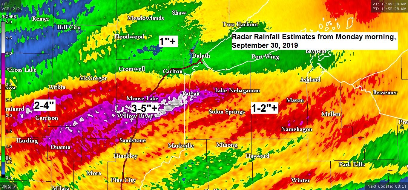
Rainfall Reports from Monday morning, September 30, 2019. Source: https://www.weather.gov/dlh/
- 2 ENE Holyoke, MN: 5.52″
- 2 SW Moose Lake, MN: 5.07″
- Kettle River, MN: 5.00″
- 1 SE Moose Lake, MN: 4.72″
- 1 S Pleasant Valley, MN: 3.79″
- 4 W Baxter, MN: 3.30″
- 5 S McGregor, MN: 3.18″
- 1 WSW Maple, WI: 3.13″
- 6 SW Finalyson, MN: 3.06″
- 2 SW Willow River, MN: 2.77″
- 2 W Ino, WI: 2.75″
- 2 S Hawthorne, WI: 2.60″
- Brainerd, MN: 2.51″
- 2 NNW Amnicon Falls, WI: 2.33″
- 13 E Solon Springs, WI: 2.32″
- Gile, WI: 2.31″
- Ashland, WI: 1.96″
- Washburn, WI: 1.89″
- Superior, WI (Airport) 1.72″
- 4 SSE Webster, WI: 1.65″
- Minong, WI: 1.58″
- 3 N Butternut, WI: 1.23″
- 3 E Wright, MN: 1.12″
- Hibbing, MN: 1.09″
- Danbury, WI: 1.06″
- Duluth, MN (Airport) 1.01″
Local Storm Reports from Monday morning, September 30, 2019. Source: https://www.weather.gov/dlh/
- 11:00 AM: Flash Flood – 2 SE McGrath, MN (Aitking County) Water over Highway 18 at the Snake River.
- 10:30 AM: Flash Flood – 1 NNE Foxboro, WI (Douglas County) The Township of Summit is reporting the Patzau Foxboro road is closed due to high water.
- 9:15 AM: Flash Flood – 4 NNW Patzau, WI (Douglas County) Douglas County Highway Department has closed County Highway W between Highway B and C where it crosses the Nemadji River due to high water.
- 6:43 AM: Flash Flood – 1 N Foxboro, WI (Douglas County)
The setup for severe weather this evening is actually quite potent, but whether or not we see anything develop remains to be seen. The area most at risk for a few strong to severe thunderstorms this evening is the red outlined area on the map below.
Warm front (red line on map) has pretty much stalled out this afternoon just north of I94 in central Minnesota while a cold front (blue line on map) moves east out of western Minnesota. Low pressure (red L on map) is lifting northeast across northern Minnesota.
Strong mid and upper level winds are spreading into the upper Midwest late today while a warm, humid and unstable air mass is in place from central Minnesota to central Wisconsin and points south. Strong wind shear of 40 to 60 knots along with Storm Relative Helicity values of around 200 m2/s2 to 300 m2/s2 were found in eastern Minnesota and west central Wisconsin as of 4 PM Monday. This is more than enough shear to produce rotating thunderstorms and an isolated tornado risk if storms can develop.
The limiting factors to get thunderstorms to develop are the warm temperatures aloft (cap) with 700mb temps of +10C, this along with generally weak forcing even with the fronts crossing the area may prevent thunderstorms from becoming severe this evening.
Source: https://weather.cod.edu

If you love weather, then you love to see a map like this. Big time temperature extremes across Minnesota today, ranging from the middle 40s in northwest Minnesota to the middle 80s in southern Minnesota. Note: La Crosse, Wisconsin had a temperature of 90 degrees at 4 PM today.

Note: We begin the month of October on Tuesday, here are the climate stats for October for Duluth, Minnesota
…Normals for the month…
Normal high on the 1st: 58 degrees; normal high on the 31st: 44 degrees
Normal low on the 1st: 40 degrees; normal low on the 31st: 30 degrees
- Average temperature: 43.2 degrees
- Precipitation: 2.85″
- Snowfall: 2.3″
…Records for October…
- Warmest: 55.9 degrees in 1963
- Coldest: 33.5 degrees in 1917
- Wettest: 7.53″ in 1949
- Driest: 0.09″ in 1895
- Snowiest: 14.0″ in 1933
Average number of 70 degree days in October: 2; most was 12 in 1963.
Average number of days with a low of 32 degrees or colder: 10; most was 24 set in 2002.
Average number of days with snowfall of at least 0.1″: 2; most was 8 set in 1925 and tied in 1959.
Astronomical Data for October
Sunrise on the 1st: 7:07 AM CDT
Sunrise on the 31st: 7:48 AM CDT
Sunset on the 1st: 6:49 PM CDT
Sunset on the 31st: 5:54 PM CDT
Low temperature forecast for Tuesday morning, October 1. Source: https://graphical.weather.gov

High temperature forecast for Tuesday, October 1

I’m keeping a close eye on model trends for Wednesday night and Thursday as some parts of the Northland could get their first snow of the season! Stay tuned

…Weather Summary…
Scattered showers and thunderstorms will be found in parts of the Northland this evening as low pressure, warm front and cold front pass through the area. This system exits to the north/east by late tonight with mainly dry conditions expected overnight. Lows tonight will be in the 40s to lower 50s.
Cooler Tuesday with mostly cloudy skies. A few showers are possible, but the greatest chance for heavier rain will be found farther south from southern Minnesota into central and southern Wisconsin. Highs Tuesday in the 40s to lower 50s with north or northwest winds 10 to 20 mph.
A potentially interesting setup for Wednesday night into Thursday morning as we could see an inverted trough develop across the upper Midwest as an area of low pressure passes well south of our area. High pressure north of Lake Superior will do its best to bring some cold air down into our area while some moisture lifts north into that cold air, result from this could be for the season’s first snow or rain mixing with snow scenario in north central into northeast Minnesota late Wednesday night into Thursday morning. As for temperatures, the NAM model is quite aggressive in bringing in the cold air with 850mb temperatures of -1 to -3C along with 925mb temperatures of around -1C, both of which are favorable for snow if near surface temps are cold enough, and those look to be in the 33 to 36 degree range late Wednesday night/Thursday morning. These early season snow events are always tricky as the temperatures aloft and near the surface could trend warmer or cooler in coming days, warmer air would result in mostly rain while cooler air results in possibly more snow.
…Looking ahead…
Friday is looking dry at the moment with rain chances returning for Saturday.
Forecast for Duluth and Superior
.Tonight… Showers or thunderstorms possible early with fog and drizzle. Mostly cloudy. Low 45 to 50. Wind east 10 to 15 mph becoming northwest with gusts to 25 mph.
.Tuesday… Mostly cloudy. A few showers possible mainly in the morning. High 50 to 55. Wind north to northwest 10 to 20 mph.
.Wednesday… Mostly cloudy. A few showers possible. High 42 to 47. Wind east to northeast 10 to 20 mph.
Thanks for reading!
Leave a Reply