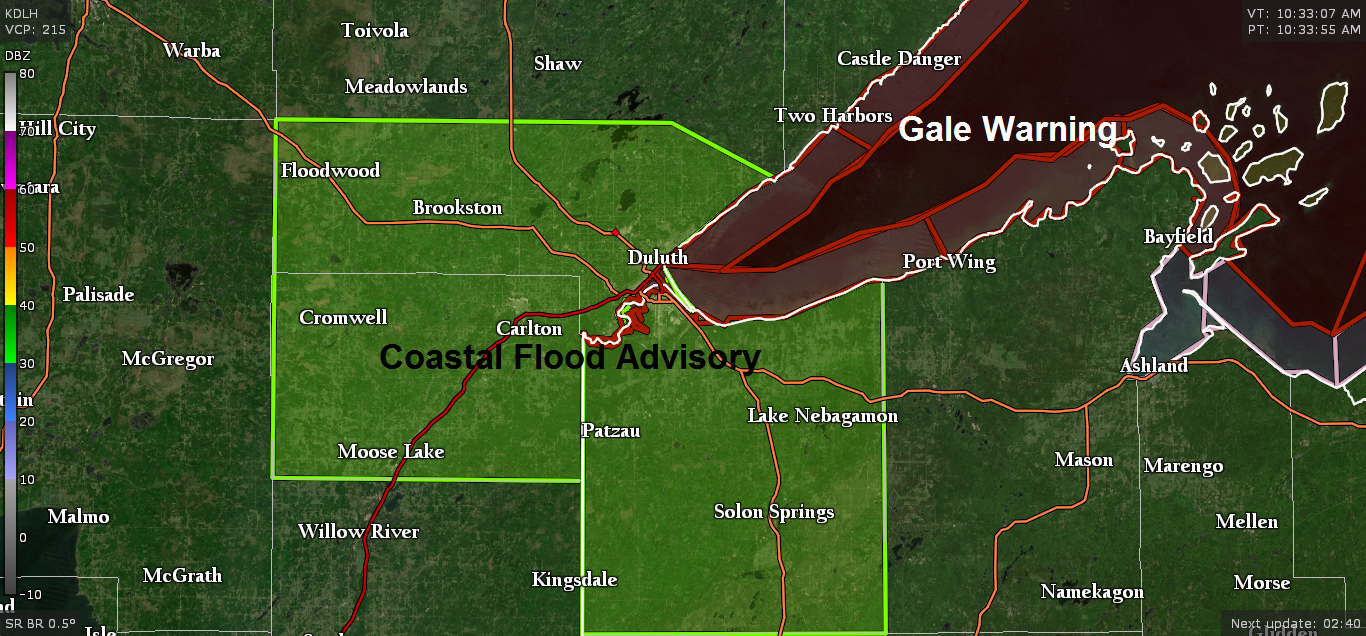
Strong northeast winds combined with very high lake levels will cause coastal flooding, especially in and around the Twin Ports through this evening. Winds and waves are expected to diminish this evening, allowing water to subside. This flooding may cause beach erosion all along the lake shore around the Twin Ports.
Source: https://www.weather.gov/dlh/
High water and waves from Lake Superior are expected to flood onto adjacent low lying land areas, including the Lakewalk in Duluth, Park Point and Brighton Beaches, and portions of Canal Park.
Flood waters may affect sidewalks and parking lots near Lake Superior. Stay out of flooded areas.
Coastal Flood Advisory has been issued until 10 PM tonight for Carlton and South St. Louis Counties in northeast Minnesota and Douglas County in northwest Wisconsin (green shaded area on map)

Power outage maps
- Minnesota Power https://www.mnpower.com/OutageCenter/OutageMap
- Lake Country Power http://outage.lcp.coop/#viewer-menu-parent
Duluth Harbor Cam link http://www.duluthharborcam.com/
…Expected Storm Impacts through this evening in northeast Minnesota and northwest Wisconsin…
1) Strong northeast winds of 20 to 40 mph near Lake Superior with gusts of 45 to around 60 mph possible.
2) Isolated power outages are possible near Lake Superior due to the high winds.
3) Widespread rain, heavy at times with rain totals from one half inch to around two inches.
Rain is lifting farther north into the Northland late this Monday morning, but it is a slow process, but expect heavier rain to reach the North Shore, Iron Range and the tip of the Arrowhead by mid to late afternoon.

14z HRRR model radar forecast through 3 AM Tuesday, October 22, 2019.
Widespread rain, heavy at times will continue to lift north/northwest across the Northland through this afternoon, then as a dry slot approaches from the south later today, this should push the steadier rain farther to the west this evening, but scattered showers and drizzle should persist across the Northland through tonight, but the heaviest and most persistent rains are expected to occur the rest of today into early this evening.
Source: https://weather.cod.edu

Strong area of low pressure over far southeast Minnesota at 11 AM Monday is forecast to lift slowly north as it reaches western Lake Superior Tuesday morning. Central pressure of this low was at around 990mb at 11 AM Monday, the low is forecast to deepen to around 981-985mb by tonight.
Source: https://www.spc.noaa.gov

Today’s storm is a classic looking fall storm on Goes-16 satellite imagery, it’s a potent one, and it will produce some wicked weather near Lake Superior for roughly the next 8 hours or so with large pounding waves on western Lake Superior, heavy rain, strong E-NE winds, and possibly some tree/power line damage along with a few power outages.
Source: https://weather.cod.edu

Thanks for reading!
Leave a Reply