Tuesday’s weather in the Twin Ports was a bit nicer compared to the wicked weather we had on Monday, and wow that was one hell of a storm that blew through on Monday! The remainder of this week looks fairly quiet in the Northland, but next week, well will worry about that when it gets here.
Strong low pressure continues to affect the upper Midwest and Great Lakes today per Goes-16 water vapor imagery from Tuesday, October 22, 2019. Source: https://weather.cod.edu

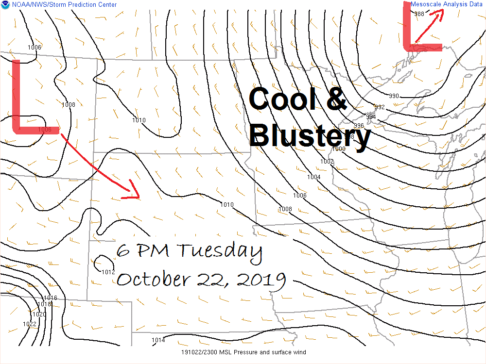
Source: https://www.spc.noaa.gov

The next few days will be cool, but a nice warm up albeit a brief one is expected on Saturday before colder temperatures return next week. Source: https://www.wpc.ncep.noaa.gov

…Latest information after Monday’s powerful storm per city of Duluth update from Tuesday afternoon, October 22, 2019…
-Brighton Beach is still closed.
-Minnesota Power crews continued to restore service as of Tuesday afternoon in parts of Duluth, Rice Lake, Island Lake, Cloquet, Carlton and Esko.
-City crews are still clearing debris on parts of Park Point and Canal Park Drive. Barricades are being removed in the Fond du Lac neighborhood.
-Duluth city officials will be doing damage assessments throughout the week to see if state or federal assistance will be needed to help with cleanup efforts.
Note: October 21, 2019 Storm Reports can be found below, including rainfall, wind and local storm reports.
Rainfall Reports from around the Northland for October 21-22, 2019. Source: https://www.weather.gov/dlh/
- 3 SSW Bruno, MN: 2.78″
- Hinckley, MN: 2.03″
- 4 SSE Webster, WI: 1.99″
- Saginaw, MN: 1.97″
- 2 E Kettle River, MN: 1.87″
- Hill City, MN: 1.86″
- Bruno, MN: 1.86″
- Siren, WI: 1.81″
- Isabella, MN: 1.77″
- Grand Rapids, MN: 1.77″
- Moose Lake, MN: 1.74″
- Cass Lake, MN: 1.73″
- Grand Portage, MN: 1.73″
- Esko, MN: 1.66″
- Danbury, WI: 1.61″
- Deer River, MN: 1.55″
- Brainerd, MN: 1.53″
- Walker, MN: 1.51″
- Minong, WI: 1.50″
- 1 WSW Two Harbors, MN: 1.50″
- Hayward, WI: 1.43″
- Effie, MN: 1.42″
- Littlefork, MN: 1.31″
- Duluth Airport: 1.28″
- Two Harbors, MN: 1.16″
- Northome, MN: 1.15″
- Hibbing, MN: 1.15″
- Lutsen, MN: 1.05″
- International Falls, MN: 1.01″
Wind Reports from Monday, October 21, 2019
- Blatnik Bridge: 74 mph
- Duluth, MN: 65 mph
- Duluth Airport: 61 mph
- Duluth Harbor: 59 mph
- Bayfield, WI: 49 mph
- Chisholm-Hibbing Airport: 49 mph
- Grand Marais, MN: 47 mph
- Cloquet, MN: 46 mph
- Ashland, WI: 44 mph
- Esko, MN: 42 mph
- Two Harbors, MN: 41 mph
- Walker, MN: 41 mph
- Brainerd, MN: 37 mph
- Hayward, WI: 37 mph
- Washburn, WI: 35 mph
- International Falls, MN: 33 mph
- Grand Rapids, MN: 32 mph
- Solon Springs, WI: 32 mph
- Hinckley, MN: 30 mph
- Ely, MN: 30 mph
- Cook, MN: 30 mph
Local Storm Reports from Monday, October 21, 2019
- 5:23 PM: Non-Thunderstorm Wind Damage. 2 WSW Rice Lake, MN (St. Louis County) A large tree was down due to high winds.
- 3:30 PM: Non-Thunderstorm Wind Damage. 2 W Duluth, MN (St. Louis County) Two large trees about one foot in diameter were uprooted due to strong winds.
- 3:00 PM: Non-Thunderstorm Wind Damage. 3 NE Duluth, MN (St. Louis County) Large pine tree fell across 21st ave on to SUV.
- 3:00 PM: Lakeshore Flood. 2 W Ashland, WI (Ashland County) Water from Lake Superior causing minor flooding on Highway 2.
- 3:00 PM: Lakeshore Flood. 1 E Duluth, MN (St. Louis County) Lift Bridge operator reports flooding around Duluth Shipping Canal.
- 2:30 PM: Lakeshore Flood. 1 N Port Wing, WI (Bayfield County) Washington Ave. Bridge over Flagg River has water over the roadway.
- 2:00 PM: Non-Thunderstorm Wind Damage. 2 NNE Duluth, MN (St. Louis County) Large pine tree fell across road and on to car.
Radar loop from Monday, October 21, 2019. Source: https://www.weather.gov/dlh/

***Record Events***
Daily precipitation record broken for October 21 at Duluth, Minnesota with 1.24″ of precipitation on Monday. The previous wettest October 21 occurred in 1949 with 1.09″ of precipitation.
It’s been a very wet fall in Duluth
Total precipitation since September 1: 10.17 inches, this is nearly +4.00 inches above normal to date (+3.91″) Note: Last fall was also a wet one in Duluth, but not nearly as wet as this fall. Precip total last year from Sept. 1 to October 22: 7.19″
Low temperature forecast for Wednesday morning, October 23. Source: https://graphical.weather.gov

High temperature forecast for Wednesday, October 23

Some of the forecast models have been hinting at quite a storm developing sometime next week, roughly around the October 29-31 time frame, unfortunately there is a lot of model disagreement from run to run so there is very low confidence on whether or not a storm will develop, and if one does develop would it even affect the Northland? Stay tuned!
Shown below is the 12z run from the European model and the European ensemble model.
The pattern shown by today’s Euro model supports storm development with significant snowfall or a rain/snow mix in the Northland around the middle of next week based on today’s storm track.
Note: One thing the forecast models do agree on is a period of cold temperatures for next week with daytime highs in the 20s and 30s in the Northland from ~October 28 to November 1 while overnight lows look to be in the teens and 20s the way it looks now.
Source: https://www.pivotalweather.com

Euro ensemble model shows no storm for the middle of next week (image below)

…Weather Summary…
The Northland will remain in the grips of a strong low pressure system which moves slowly N-NE through central Ontario and Hudson Bay through Thursday morning.
Now that we’re on the backside of this storm we can look forward to colder temperatures along with some light precipitation in the form of drizzle and snow. No major snow accumulation is expected through Thursday with maybe a dusting to an inch of snow in spots in northern Minnesota (north of Duluth)
Generally mostly cloudy skies are expected through Thursday, although some breaks in the clouds will likely occur from time to time.
850mb temperatures will be on the chilly side the next few days, ranging from around -4 to -9C.
Lows tonight and Wednesday night will be in the 30s, but a few spots could fall into the 20s especially Wednesday night.
Highs Wednesday and Thursday will be in the 30s to around 40 degrees.
Winds will be out of the northwest at 10 to 20 mph with gusts to 30 mph tonight and Wednesday.
Forecast for Duluth and Superior
.Tonight… Breezy. Mostly cloudy. Light rain and drizzle at times. Low 35 to 38. Wind west to northwest 10 to 20 mph with gusts to 30 mph.
.Wednesday… Breezy. Mostly cloudy (few peeks of sun) Few showers. High 38 to 41. Wind northwest 15 to 25 mph.
.Thursday… Partly to mostly cloudy. Flurries possible in the morning. High 35 to 40. Wind northwest 10 to 20 mph.
Normal temperatures for October 23
- High 48
- Low 33
- Sunrise Wednesday 7:38 AM CDT
- Sunset Wednesday 6:08 PM CDT
Thanks for reading!
Leave a Reply