The amount of precipitation that has fallen so far this year in the upper Midwest is mind boggling!
Precipitation Totals and departure from normal from January 1 to October 22, 2019
- Green Bay, WI: 42.52″ (+17.31″ above normal)
- Eau Claire, WI: 39.39″ (+11.79″ above normal)
- Twin Cities, MN: 39.06″ (+11.95″ above normal)
- St. Cloud, MN: 38.73″ (+13.76″ above normal)
- Brainerd, MN: 32.52″ (+7.17″ above normal)
- Grand Forks, ND: 30.85″ (11.21″ above normal)
- International Falls, MN: 30.49″ (+8.98″ above normal)
Note: Duluth has picked up 29.34″ of precipitation so far this year which is less compared to other cities listed above, but is still above normal by 2.38″. This past summer was a lot drier in Duluth compared to other cities around the region which is why our precipitation total is less compared to other cities so far this year, if we had even normal precip totals in July and August, our yearly precip total would be sitting ~35″ right now instead of 29″.
Anywhere you see green on the map below indicates above normal precipitation with the darker green and blue colors indicating precipitation totals that have been well above normal so far this year.
Total Precipitation, percent of normal from January 1 to October 23, 2019. Source: https://mrcc.illinois.edu/

Fall 2019 has been a wet one across the Northland, check out how much precipitation has fallen so far this fall, and the departure from normal (through October 22)
- International Falls: 11.53″ (+6.98″ above normal)
- Brainerd: 10.52″ (+5.09″ above normal
- Duluth: 10.17″ (+3.91″ above normal)
Source: https://mrcc.illinois.edu/

The entire Northland is running well above normal in precipitation so far this fall.
Total Precipitation, percent of normal from September 1 to October 22, 2019.

Wet weather has been widespread this fall with well above normal precipitation totals stretching from the Northern Rockies to the upper Midwest while drier than normal conditions have occurred farther south, including over the Ohio Valley and Central Rockies.

Low temperature forecast for Thursday morning, October 24. Source: https://graphical.weather.gov/

High temperature forecast for Thursday, October 24

The pattern per some of the forecast models for next week looks favorable for storm development, but there continues to be a lot of model variability for next week, and it will likely take several more days for the models to settle down a wee bit.
Here’s what I’m seeing per Euro and Canadian models for next week.
-Strong ridging over western Canada and along the East coast while a strong trough digs south/east across the Rockies and Plains.
-Will the trough move too quick which leads to storm development occurring too far east (number 3 on map below) or will the trough move slow enough to the east allowing storm development to occur farther west (numbers 1 and 2 on map below)
-Or will the northern stream be too strong resulting in just a light dusting of snow as an upper low scoots across the Northern Plains and upper Midwest (number 4 on map below)
Note: If you’re a fan of snow and you live in the Northland, you’ll want tracks 1 or 2 to verify. Track 4 would still give us a little snow, but not as much as tracks 1 or 2 would give us.
Source: https://www.pivotalweather.com/


…Weather Summary…
A cool late October day, but certainly not a cold day, and nothing out of the ordinary at all for this time of the year. Highs today ranged from the upper 30s to middle 40s. Note: Normal highs on October 23 are in the upper 40s.
Sky conditions varied between partly sunny and mostly cloudy today with another day of scattered drizzle, and in some locations light snow showers as moisture continues to wrap around a strong low pressure system which has reached Hudson Bay today. A tight pressure gradient remained over the upper Midwest today resulting in another breezy day with northwest winds 10 to 25 mph.
Scattered snow showers and drizzle will continue in parts of the area tonight under partly to mostly cloudy skies. Snowfall amounts of a dusting to an inch are possible by daybreak in a few spots in northern Minnesota (north of Duluth) Lows tonight will be in the upper 20s to middle 30s with northwest winds 5 to 15 mph with gusts to 25 mph.
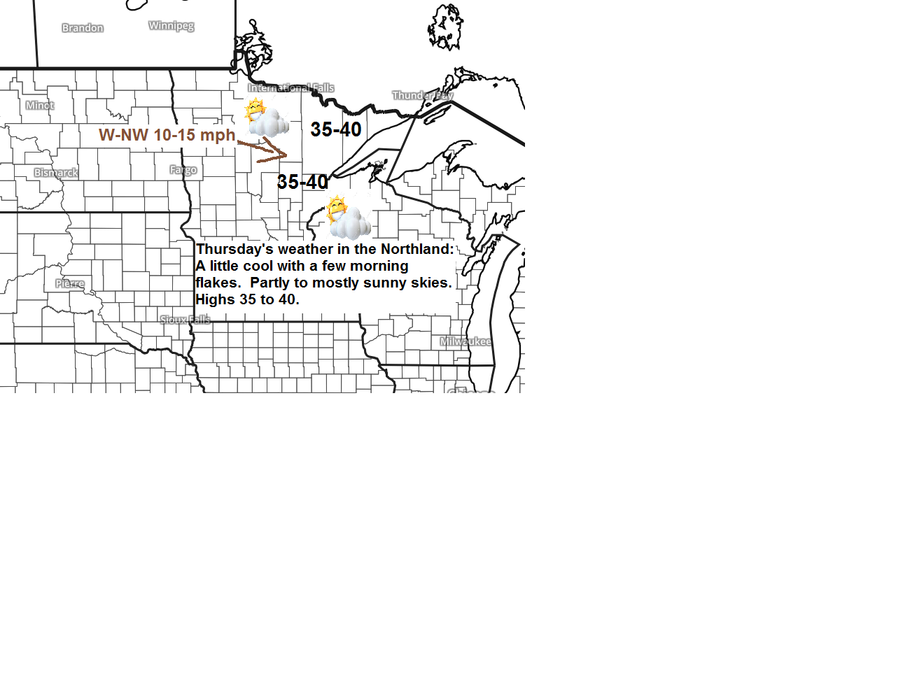
A few flurries or snow showers are possible Thursday morning, otherwise we’re looking at partly to mostly sunny skies Thursday with highs in the middle 30s to lower 40s. Winds will be out of the west at 10 to 15 mph.
Milder weather Friday and Saturday (‘mildest’ day on Saturday) Highs Friday are forecast to be in the 40s to around 50 degrees with Saturday’s highs in the 50s.
A cold front is forecast to move through the Northland Saturday night, and this will lead to a period of colder than normal temperatures for most of next week the way it looks now. Note: Low temps might dip into the teens in some parts of the Northland sometime next week with daytime highs in the middle 20s to middle 30s.
Forecast for Duluth and Superior
.Tonight… Partly to mostly cloudy. Isolated rain showers possible this evening, and snow or rain showers overnight. Low 32 to 36. Wind northwest 10 to 20 mph.
.Thursday… Flurries possible early. Partly to mostly cloudy. High 37 to 42. Wind northwest 10 to 15 mph.
.Friday… Partly cloudy. High 45 to 50. Wind southwest 10 to 20 mph.
Normal temperatures for October 24
- High 48
- Low 32
- Sunrise Thursday 7:39 AM CDT
- Sunset Thursday 6:06 PM CDT
Thanks for reading!
Leave a Reply