Well it finally looks like will get our first freeze (low temp of 32 F) of the season here in Duluth Friday morning, roughly 4 weeks later than normal.
Still a lot of uncertainty with next week’s weather, at least when it comes to whether or not we get a storm to develop.
-Forecast models all agree on a strong and deep trough pushing south out of Canada by early next week, but they disagree on how quickly the trough will push to the east.
-GFS model remains the most progressive model in shoving the trough and cold air far to the south/east next week with no potential for a storm.
-The European and Canadian models continue to show the potential for a potent storm to develop sometime next week across the Plains with a more amplified pattern, but there is very little consistency from run to run.
-I’m even looking at the German-Icon model for next week’s forecast. Tough pattern to try to figure out, need all the help I can get. By the way the German-Icon model spins up a major storm mid to late next week, although the track is too far east for it to affect the Northland, at least on the 12z run from today.
So for now everyone can sit back and relax if you don’t want snow as there continues to be a ton of model disagreement for next week, and I suspect the models won’t get a good handle on things until late this weekend at the earliest.
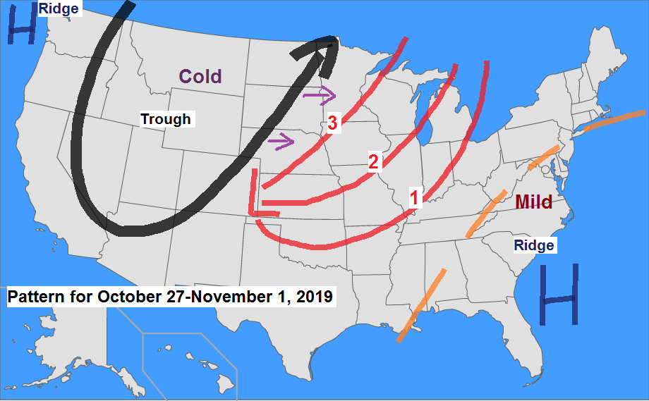
The image below shows the basic weather pattern for next week with strong ridges over western Canada and across the eastern US while a strong trough pushes south/east out of the Rockies.
The red L on the map is where a low pressure system may develop next week with three possible tracks (red lines on map) Note: Track 3 looks less likely per today’s model trends while tracks 1 or 2 look more likely per today’s trends. Bottom line — it looks like we could get a little snow in the Northland next week, but right now it doesn’t look like it would be a major winter storm.
Stay tuned!

Next week’s cold shot looks impressive! Check out the high temperature anomaly forecast valid for next Wednesday, October 30th — Daytime highs running 20 to 35 degrees colder than normal across the Rockies and Plains. Source: https://www.wpc.ncep.noaa.gov/

Low temperature forecast for Friday morning, October 25. Source: https://graphical.weather.gov/

High temperature forecast for Friday, October 25

Quite the early season winter storm today in the Texas Panhandle with a few instances of Thundersnow today. Impressive looking system on Goes-16 water vapor imagery from October 24, 2019. Source: https://weather.cod.edu/

Radar loop ending at 4:45 PM CT, Thursday, October 24, 2019. Source: https://www.wunderground.com/
Blue=Snow/Green=Rain

This is pretty cool! Always nice to see some snow in the Southern Plains! Check out the temperature contrast this afternoon, ranging from the 30s in the Texas Panhandle to the 80s in central and south Texas.
Source: http://mp1.met.psu.edu/

…Weather Summary…
Clouds took a while to decrease today, but they did from west to east this afternoon with mostly sunny to partly cloudy skies across much of northeast Minnesota late this afternoon while more clouds were found in northern Wisconsin.
Cool late October temperatures continued today with highs in the upper 30s to middle 40s with west or northwest winds at 5 to 15 mph with gusts to around 25 mph.
Partly to mostly cloudy skies will be found over the area tonight with lows in the 20s to lower 30s with a few teens possible in the typical cold spots. Winds will shift out of the southwest tonight at around 10 mph.
A pleasant Friday ahead under partly to mostly sunny skies. Highs will range from the middle 40s to middle 50s with southwest winds 10 to 20 mph with gusts to 25 mph.
Cold front is forecast to move through the Northland Saturday night, but before this happens will get one more mild day on Saturday with highs in the middle 40s to middle 50s.
There is a chance for a few rain and snow showers from Saturday night into Sunday but no snow accumulation is expected the way it looks now.
Sunday will mark the beginning of a downward trend in temperatures with highs forecast to be in the middle 30s to lower 40s, and this chilly pattern looks like it will linger through most of next week.
Forecast for Duluth and Superior
.Tonight… Partly cloudy. Low 27 to 32. Wind becoming southwest around 10 mph.
.Friday… Partly to mostly sunny. Breezy. High 49 to 54. Wind southwest 15 to 25 mph.
.Saturday… Partly to mostly sunny. High 51 to 56. Wind south to southwest 10 to 20 mph.
Normal temperatures for October 25
- High 47
- Low 32
- Sunrise Friday 7:41 AM CDT
- Sunset Friday 6:04 PM CDT
Thanks for reading!
Leave a Reply