Finally beginning to see the forecast models come into better agreement for next week, minus that one model which doesn’t have a clue what the hell is going on. Looks like the majority of the Northland will miss out on accumulating snowfall next week, could be a skiff here and there, but no blockbuster winter storms, at least not yet.
We may see two low pressure systems develop across the Plains next week, but both are forecast to track too far south/east to impact our area.
The first system could put down a few inches of snow sometime in the late Monday to late Tuesday time frame (October 28-29) from far southeast Minnesota to central Wisconsin into parts of upper Michigan. The second system looks to track even farther south/east compared to the first one with timing of that one in the October 30-November 1 time frame.
Source: 12z European ensemble model 10.25.19; https://weathermodels.com/

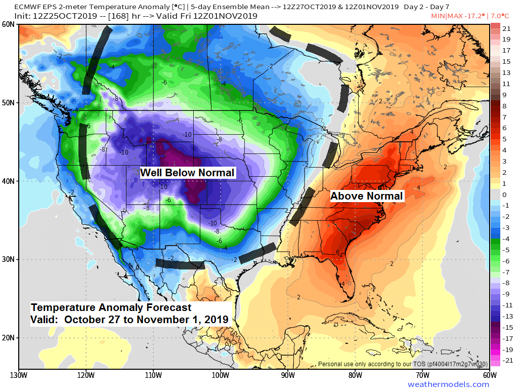
Next week does look chilly with the greatest departures from average centered on the Rockies into the Central Plains (-10 to -25 degrees below normal!)
Source: 12z European ensemble model 10.25.19

Low temperature forecast for Saturday morning, October 26. Source: https://graphical.weather.gov/

High temperature forecast for Saturday, October 26

Quite an interesting weather pattern in place the last few days, and it continues again today (it’s almost El Nino like) Warmer across the Northern Rockies compared to parts of the Southern Plains today. Temperatures in the 90s continue in parts of California today. It was warmer in Duluth, Minnesota (53 degrees) than it was in Dallas, Texas (48 degrees) late this Friday afternoon, yes that has happened before, but still cool to see.
Source: https://www.spc.noaa.gov/

Significant river flooding continues in areas shaded in red on map below. Outlook valid through October 30, 2019. Source: https://www.weather.gov/

Snow cover fading away in the Texas panhandle this Friday afternoon per Goes-16 visible satellite imagery. Note: Snow cover doesn’t move, while clouds move on the image below.
Source: https://weather.cod.edu/

…Weather Summary…
It’s official! The first freeze of the season occurred in Duluth Thursday night, October 24 with a temperature of 30 degrees, this is the first time since May 7 with a temperature lower than 32 degrees. Note: The first freeze last year in Duluth was on September 29 compared to October 24 this year, just a little bit of a difference! Last year’s first freeze was right on schedule, but this year’s first freeze was roughly 3 weeks later than normal.
Note: The pattern is changing! Up to now the fall of 2019 has been very wet and stormy in the Northland, but things are changing. The upper level winds will be shifting more to the NW next week into early November, this decreases the odds of our area being impacted by a powerful storm in the next 1 to 2 weeks, but this type of pattern is favorable for an occasional clipper type system to swoosh down from Canada which could bring a little snow/rain to the area.
A beautiful late October day in the Northland with lots of sunshine although we have seen some high level clouds spill SE into northern Minnesota this afternoon. Highs today were in the 50s with a gusty southwest wind from 10 to 25 mph.
Quiet in the Northland tonight with clear to partly cloudy skies. Lows will be in the 30s to around 40 degrees with southwesterly breezes at 10 to 20 mph.
Will squeeze out one more mild day on Saturday before cooler weather settles in. Partly to mostly sunny skies with highs in the 50s are expected on Saturday, might even get close to 60 degrees in a few locations. Winds will be out of the south-southwest at 10 to 20 mph with gusts to 25 mph.
Cold front slices through the Northland Saturday night-Sunday morning. Forecast models spit out a little light rain or snow along and behind this front from Saturday night through the day Sunday but little to no snow accumulation is expected the way it looks now. Highs on Sunday are forecast to range from the middle 30s to lower 40s.
Most of next week looks chilly around here, likely won’t be breaking any cold temperature records in our area, but regardless it still looks chilly for this time of the year with daytime highs mainly in the 30s with overnight lows in the 20s to around 30 degrees with some parts of the area possibly dipping into the teens on a few nights next week.
Forecast for Duluth and Superior
.Tonight… Mostly clear. Low 34 to 39. Wind southwest 5 to 15 mph.
.Saturday… Mild and breezy. Partly cloudy. High 55 to 60. Wind south to southwest 10 to 20 mph with higher gusts possible.
.Sunday… Breezy and cooler. Mostly cloudy (few peeks of sun) High 37 to 42. Wind northwest 10 to 20 mph.
Normal temperatures for October 26
- High 47
- Low 32
- Sunrise Saturday 7:42 AM CDT
- Sunset Saturday 6:03 PM CDT
Thanks for reading!
Leave a Reply