We have the cold, now we just need some snow, and it looks like will get a little bit of snow in the Northland on Friday, won’t be much as accumulations remain less than one inch.
Keeping an eye on another system late this weekend-early next week, that one may pack a little more of a punch with a few inches of snow possible in some parts of the Northland, and a snow to rain scenario in other parts of the area.
A busy weather headlines map today! Winter weather continues across parts of the Rockies spreading into the Plains tonight and Wednesday. Freeze warnings in parts of Texas, while extreme fire weather conditions continue in parts of California, also in parts of Arizona.
Source: https://www.pivotalweather.com/

Low of 23 degrees at the Duluth Airport Tuesday morning, October 29 — Coldest temperature since April 15, low of 21 degrees.
International Falls and Hibbing, Minnesota both had a top 5 lowest maximum temperature on record for October 28.
Low temperature reports of 20 F or colder from Tuesday morning, October 29, 2019. Source: https://www.weather.gov/dlh/
- Hibbing, MN: 14F
- Cotton, MN: 17F
- Embarrass, MN: 17F
- Kabetogama, MN: 19F
- Two Harbors, MN: 19F
- Silver Bay, MN: 19F
- Orr, MN: 19F
- Crane Lake, MN: 19F
- Eveleth, MN: 19F
- Bigfork, MN: 19F
- Aitkin, MN: 19F
- Cass Lake, MN: 19F
- 3 E Wright, MN: 20F
- 25 E Ely, MN: 20F
- 3 E Orr, MN: 20F
- 4 W Clam Lake, WI: 20F
Ingredients coming together to produce some snow for Halloween, but this won’t impact the Northland.
Source: https://weather.cod.edu/

The extent of the cold airmass is impressive for this time of the year. If you like it warmer, your only options are the deep south or parts of the southwest U.S.; eastern U.S.
Source: https://lab.weathermodels.com/

Note: High temperature in Denver, Colorado today was around 20 degrees which occurred early this morning, temperature at 3 PM this afternoon was 11 degrees! The normal high in Denver on October 29 is 60 degrees!
A closer look at Midwest temperatures from Tuesday afternoon. Single digits showing up in parts of Wyoming and Colorado this afternoon! Big time cold blast for late October.

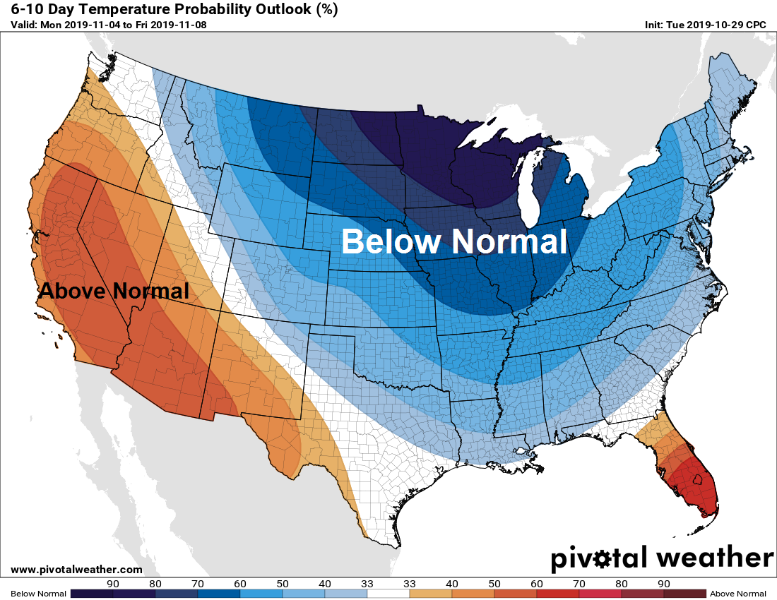
High probabilities for below normal temperatures next week across the upper Midwest and Great Lakes, and anywhere you see blue colors on the map below. Source: Climate Prediction Center; https://www.pivotalweather.com/
Temperature Outlook valid November 4-8, 2019

Low temperature forecast for Wednesday morning, October 30. Source: https://graphical.weather.gov/

High temperature forecast for Wednesday, October 30

…Weather Summary…
Highly amplified weather pattern will remain in place the next few days. A strong and deep trough covered the western US with a ridge across the southeast and eastern US.
850mb temperatures at 5 PM today ranged from -14C in northwest Minnesota to -8C in southern Minnesota.
Partly to mostly cloudy skies will be found in the Northland tonight and Wednesday with a few flurries possible.
Lows tonight will be in the teens and 20s, highs on Wednesday in the upper 20s to around the freezing mark.
Winds tonight and Wednesday will be out of the west or southwest at 10 to 15 mph with gusts to around 20 mph.
Halloween looks chilly but dry in the Northland. Highs ranging from 29 to 36 degrees, cooling to the mid 20s to around 30 degrees Thursday evening.
Forecast for Duluth and Superior
.Tonight… Partly cloudy. Low 17 to 22. Wind southwest 5 to 15 mph.
.Wednesday… Partly cloudy. High 30 to 35. Wind west to southwest 10 to 20 mph.
.Halloween… Partly cloudy. High 30 to 35. Wind northwest 10 to 15 mph.
Normal temperatures for October 30
- High 45
- Low 30
- Sunrise Wednesday 7:48 AM CDT
- Sunset Wednesday 5:56 PM CDT
Thanks for reading!
Leave a Reply