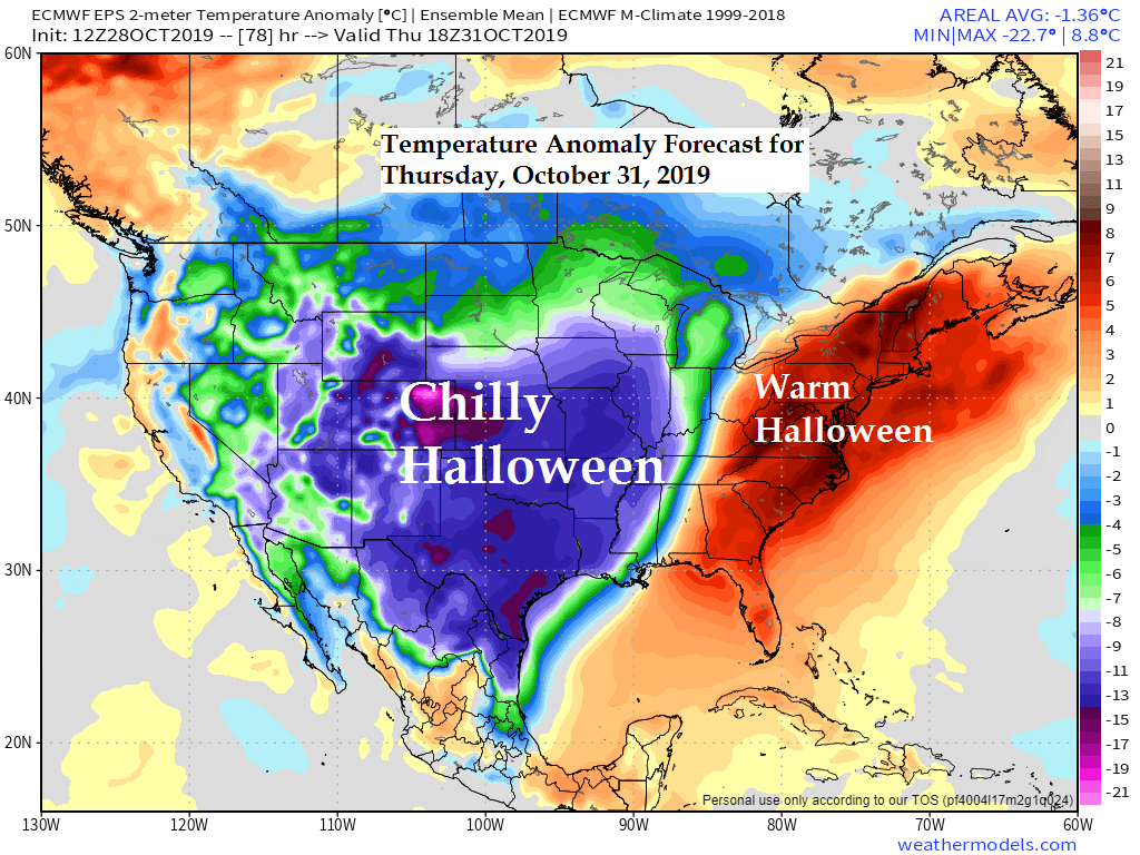
Looks like will have a cold Halloween over a large part of the U.S. with temperatures on Thursday some 10 to 25 degrees below normal from the Rockies to the Central and Southern Plains into northern portions of Mexico!
Eastern US will be the warm spot this Halloween.
Note: Normal highs in the Northland on Halloween are in the low to mid 40s, looks like will have highs in the 30s this Halloween, cooling into the 20s to around 30 degrees Thursday evening.
Source: 12z European ensemble model 10.28.19; https://weathermodels.com/

A few inches of snow are likely south and east of the Northland tonight where a Winter Weather Advisory is in effect (purple shaded area on map)
Source: https://www.pivotalweather.com/

Long range forecast models continue to show a break in the wet/active pattern across the upper Midwest with below normal precipitation forecast thru November 12. Generally speaking it looks like will be locked in a northwest or a west-northwest flow aloft for about the next 2 weeks which means no major storms impacting the Northland, instead will be seeing clipper type systems occasionally affecting the area starting later this week with mostly light amounts of snow or rain.
Source: 12z European ensemble model 10.28.19

Significant river flooding continues in the areas shaded in red on the map below. Source: https://www.wpc.ncep.noaa.gov/

Low temperature forecast for Tuesday morning, October 29. Source: https://graphical.weather.gov/

High temperature forecast for Tuesday, October 29

…Weather Summary…
Didn’t get as much sun as I had hoped we would get today, but that isn’t too unusual this time of year as sunny days are generally few and far between in late fall.
There were some sunny breaks in the Northland today, but overall skies were mostly cloudy, and it was crisp with daytime highs in the low to mid 30s. Winds today were out of the west or southwest at 10 to 15 mph.
Very little change is expected with our weather the next few days as a cold airmass will remain in place with 850mb temperatures of around -8 to -14C through Thursday.
Low temperatures tonight and Tuesday night are forecast to range from the upper teens to around 30 degrees with highs Tuesday in the lower 30s to around 40 degrees, highs on Wednesday mainly in the 30s.
Mostly cloudy to partly cloudy skies will continue tonight and Tuesday. Note: Some light snow is possible tonight in eastern portions of northwest Wisconsin, roughly along and east of a line from Shell Lake to Hurley with a dusting to an inch of snow possible tonight. The remainder of the Northland should be mainly dry through midweek, although a few flurries or snow showers are possible from time to time, but nothing widespread, and no accumulations are expected.
A cold front is forecast to move through the Northland on Friday with a little light snow or mixed precipitation possible.
Forecast for Duluth and Superior
.Tonight… Partly to mostly cloudy. Low 24 to 29. Wind southwest around 10 mph.
.Tuesday… Partly to mostly cloudy. High 35 to 39. Wind southwest 10 to 15 mph.
.Wednesday… Partly cloudy. High 33 to 37. Wind west 10 to 20 mph.
Normal temperatures for October 29
- High 45
- Low 30
- Sunrise Tuesday 7:46 AM CDT
- Sunset Tuesday 5:58 PM CDT
Thanks for reading!
Leave a Reply