Cold air is on the move today! 60 degrees in Duluth Saturday afternoon, 40 to 45 degrees this afternoon.
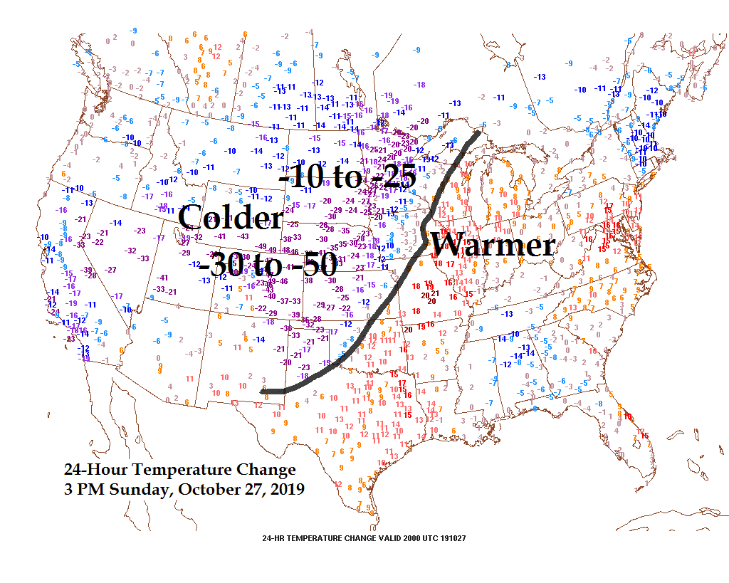
Check out the 24-hour temperature change from Saturday afternoon (3 PM) to Sunday afternoon (3 PM) Some locations in the Rockies and Western High Plains are running 30 to nearly 50 degrees colder this afternoon compared to Saturday afternoon.
Source: http://mp1.met.psu.edu/

Source: https://www.spc.noaa.gov/

Temperature anomaly forecast valid from October 28 to November 2 — Greatest departures from normal covering the Rockies into the Plains (Purple and blue colors on map) Source: 12z European ensemble model 10.27.19; https://weathermodels.com/

A few inches of snow remain possible Monday night into Tuesday morning well southeast of the Northland. Source: 12z European ensemble model 10.27.19

Significant River Flood Outlook valid thru November 1, 2019. Source: https://www.wpc.ncep.noaa.gov/

Low temperature forecast for Monday morning, October 28. Source: https://graphical.weather.gov/

High temperature forecast for Monday, October 28

Temperature and Precipitation report for Duluth, Minnesota for October 20-26, 2019
High Temperatures/Departure from Normal
- 10/20: 64F/+14 degrees above normal
- 10/21: 50F/+1 degree above normal
- 10/22: 49F/Normal
- 10/23: 47F/-1 degree below normal
- 10/24: 45F/-3 degrees below normal
- 10/25: 53F/+6 degrees above normal
- 10/26: 60F/+13 degrees above normal
Low Temperatures/Departure from Normal
- 10/20: 35F/+1 degree above normal
- 10/21: 47F/+14 degrees above normal
- 10/22: 38F/+5 degrees above normal
- 10/23: 36F/+3 degrees above normal
- 10/24: 30F/-2 degrees below normal
- 10/25: 30F/-2 degrees below normal
- 10/26: 41F/+9 degrees above normal
Average temperature for the week of October 20: 44.6 degrees; +4.2 degrees above normal. Source: https://www.dnr.state.mn.us/
- Total Precipitation: 1.37″
- Normal: 0.56″
- Departure: +0.81″ above normal
State Average for Minnesota for the week of Oct. 20, 2019
- Temperature: 42.0 degrees
- Departure: -1.3 degrees below normal
- Precipitation: 1.42″
- Departure: +0.99″ above normal
Temperature departure map for the week of October 20, 2019. Source: https://mrcc.illinois.edu/

Precipitation departure map for the week of October 20, 2019

…Weather Summary…
Mostly cloudy and cooler in the Northland today with occasional sunny breaks along with areas of light rain showers and snow flurries. Temps this afternoon ranged from the mid 30s to mid 40s with a northwest breeze at 10 to 20 mph.
The Northland will get an extended break in any significant precipitation events this week thanks to a colder/drier airmass which will force the storm track farther to the south and east.
There will be the occasional flurry or snow shower at times tonight into early Monday, otherwise the next few days look mainly dry in our area.
Long term may turn a little more active, but these systems will be moisture starved as they originate from western Canada, result from this will be mostly light snow and or rain events beginning late this week and carrying over into next weekend with some light snowfall accumulation possible in some parts of the Northland, but doesn’t look like there will be any major winter storm impacting the Northland through the end of the month through the first few days of November.
Sky conditions through Tuesday will vary between mostly cloudy and partly cloudy, so it looks like will see at least a little bit of sunshine Monday and Tuesday.
Lows tonight and Monday night will be in the 20s to around 30 degrees. Highs Monday and Tuesday mainly in the 30s.
Northwest to west winds tonight followed by southwest winds on Monday. Wind speeds of 10 to around 20 mph.
Forecast for Duluth and Superior
.Tonight… Mostly cloudy. A few flurries possible. Low 27 to 31. Wind northwest 10 to 20 mph becoming west to northwest late.
.Monday… Partly to mostly cloudy. High 34 to 38. Wind southwest 10 to 15 mph.
.Tuesday… Partly to mostly cloudy. High 35 to 40. Wind west to southwest 10 to 15 mph.
Normal temperatures for October 28
- High 46
- Low 31
- Sunrise Monday 7:45 AM CDT
- Sunset Monday 5:59 PM CDT
Thanks for reading!
Leave a Reply