Three systems this week with the second and third systems looking the most impactful.
-System one late tonight into Monday affects northern Minnesota with some wet snow and rain but snowfall totals should be fairly light and no major travel issues are anticipated at this time.
-The second system has been trending farther north in model guidance over the last few days, and now it looks like there could be some accumulating snow that affects portions of the Northland, especially from eastern Minnesota into northwest Wisconsin from late Tuesday afternoon into Wednesday afternoon.
-Third system is still a ways off but if it tracks far enough north, then it could bring another round of accumulating snow to parts of the Northland around November 29-December 1.
Here’s my snowfall forecast for late tonight and Monday.
Potential for trace to 2 inch amounts across northern Minnesota, and there is also a chance for some rain and patchy light freezing rain tonight.

Radar forecast valid from 6 PM this evening to 6 PM Monday.
Snow (blue) mixed precip (pink) rain (green)
Source: 18z HRRR model 11.24.19; https://weathermodels.com/


Winter Storm Watch has been issued for parts of northwest Wisconsin (blue area on map) from Tuesday evening through Wednesday morning. Some cities included in the watch are Siren, Grantsburg, Minong, Shell Lake, Hayward, Bayfield, Ashland and Hurley.
Heavy snow and gusty winds are possible in the watch area with very difficult travel conditions possible Tuesday night into Wednesday.
Source: https://www.weather.gov/dlh/

Here’s a wider view showing the winter weather headlines that have been issued for the Tuesday-Wednesday storm.
Source: https://www.pivotalweather.com/

Low temperature forecast for Monday morning, November 25. Source: https://graphical.weather.gov/

High temperature forecast for Monday, November 25.

Temperature and Precipitation report for Duluth, Minnesota for November 17-23, 2019.
| High temperatures/Departure from normal 11/17: 38F/+3 degrees above normal 11/18: 30F/-4 degrees below normal 11/19: 34F/Normal 11/20: 39F/+6 degrees above normal 11/21: 33F/+1 degree above normal 11/22: 29F/-3 degrees below normal 11/23: 42F/+11 degrees above normal Low temperatures/Departure from normal 11/17: 31F/+10 degrees above normal 11/18: 28F/+7 degrees above normal 11/19: 28F/+8 degrees above normal 11/20: 32F/+12 degrees above normal 11/21: 18F/-1 degree below normal 11/22: 15F/-3 degrees below normal 11/23: 22F/+4 degrees above normal Average temperature for the week of November 17: 29.9 degrees; +3.7 degrees above normal. Source: https://www.dnr.state.mn.us/ Total precipitation: 0.59″ Normal: 0.48″ Departure: +0.1″ above normal State average for Minnesota for the week of November 17th. Temperature: 32.3 degrees Departure: +4.1 degrees above normal Precipitation: 0.56″ Departure: +0.20″ above normal | |
Average temperature departure from normal for the week of November 17, 2019. Source: https://mrcc.illinois.edu/

Precipitation departure map for the week of November 17, 2019.

…Weather Summary…
Mild temps continued today with highs in the upper 30s to middle 40s, but upper 40s and 50 degree temps were reported in Superior and at the Duluth Harbor this afternoon.
Low pressure over southeast Saskatchewan late this Sunday afternoon is forecast to move east to slightly east of southeast through Monday night with the low moving to central Lake Superior by Monday night. Some precipitation will occur over parts of the Northland tonight and Monday with light rain, wet snow and perhaps some patchy freezing rain. Note: The greatest chance for snow and freezing rain should remain over northern Minnesota, and this area also has the highest chance for getting precipitation tonight and Monday with a lower chance of precipitation for east-central Minnesota and northwest Wisconsin.
Lows tonight will mainly be in the low to mid 30s with winds out of the south or southeast at 10 to 15 mph.
Highs on Monday will be in the 30s to lower 40s with winds out of the south, southwest or northwest at 10 to 20 mph with higher gusts possible.
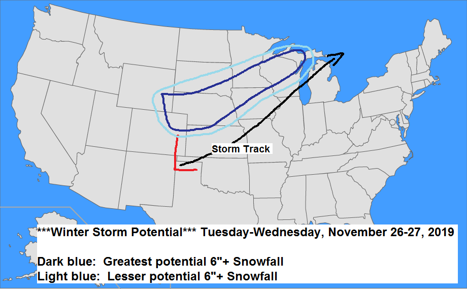
A winter storm may impact pars of the Northland Tuesday evening into Wednesday. Low pressure is forecast to develop over the Southern Rockies on Monday, this low is then forecast to deepen as it lifts NE into the Plains and eventually the central/eastern Great Lakes by Wednesday. Models have been shifting the storm track farther north over the last few days with a much stronger trough which could become negatively tilted as it lifts into the Great Lakes. This system has the potential to produce a significant amount of snow along with strong winds from late Tuesday into Wednesday. At this time it appears that southeast portions of the area including northwest Wisconsin and far eastern Minnesota could be impacted by this storm, and a winter storm watch has been issued for those areas. It does look like will get some snow in Duluth Tuesday night and Wednesday due to this system tracking farther north, but the greatest amounts look to fall south/east of the Twin Ports, unless this system nudges a little farther north which is possible. Note: A period of gusty NE winds are also possible in the Twin Ports Tuesday night with wind gusts of 20 to 30 mph possible, this could cause areas of blowing snow if we do get some snow.
There is another storm that has been showing up in the models during the November 29-December 1 time frame, this one also needs to be watched as it could bring another round of heavy snow and strong winds to parts of the upper Midwest and Great Lakes, and if this system takes a favorable track, then it may also impact parts of the Northland after Thanksgiving.
Forecast for Duluth and Superior
.Tonight… Mostly cloudy. Some light rain possible. Low 31 to 35. Wind southwest becoming south to southeast at 10 to 15 mph.
.Monday… Mostly cloudy. Some light rain possible at times. High 37 to 42. Wind southwest 15 to 20 mph.
.Tuesday… Mostly cloudy. High 30 to 35. Wind becoming east to northeast 10 to 15 mph.
| Normal temperatures for November 25 High 30 Low 17 Sunrise Monday 7:25 AM CST Sunset Monday 4:26 PM CST | |
Thanks for reading!
Leave a Reply