Strong low pressure over eastern Kansas at 5 PM Tuesday will lift northeast reaching Lake Huron by Wednesday evening. This system will bring widespread snow, blowing snow and strong winds to northwest Wisconsin, east-central Minnesota and parts of northeast Minnesota tonight into Wednesday.
Source: https://www.spc.noaa.gov/

As that potent trough lifts NE out of the Plains tonight it will become negatively tilted. Strong lift will spread north with the trough causing heavy snow bands to develop early Wednesday morning in parts of east-central Minnesota and northwest Wisconsin, snowfall rates of 1 to around 2 inches per hour are possible in those aforementioned areas late tonight-Wednesday morning.

Winter Storm Warning (pink)
Winter Weather Advisory (purple)
Headlines map as of 4 PM Tuesday, November 26. Source: https://www.weather.gov/dlh/

Low probabilities for blizzard conditions early Wednesday morning through mid-afternoon Wednesday along the South Shore of Lake Superior in northern Wisconsin, including the Bayfield Peninsula and Ashland areas.
Source: 12z HREF model 11.26.19; https://www.spc.noaa.gov/

…Marine Information…
Storm warning for western Lake Superior from Two Harbors to Duluth, the entire South Shore of Lake Superior, a gale warning for the remainder of the North Shore (north of Two Harbors)
Waves 14 to 20 feet in the storm warning, and 10 to 18 feet in the gale warning. Winds NE 25-40 knots, gusts to 55 knots. Note: Largest waves and strongest winds are expected along the South Shore of Lake Superior.
…Lakeshore Flood Information…
The combination of strong northeast to north winds and large waves crashing ashore may lead to lakeshore flooding and beach erosion along the South Shore of Lake Superior from late tonight through the day Wednesday. Areas impacted include Saxon Harbor, Ashland, Sand Bay, Port Wing, Twin Ports including Canal Park, Minnesota Point, Wisconsin Point and Fond Du Lac.

Radar loop ending at 4:40 PM Tuesday, November 26, 2019. Snow shield creeping north into southern Minnesota late this Tuesday afternoon. Also seeing some lake effect snow showers over the southwestern tip of Lake Superior near the Twin Ports late this Tuesday afternoon.
Source: MRMS radar; https://lab.weathermodels.com/

Radar forecast valid through 7 PM Wednesday
Snow spreads slowly north into east-central Minnesota, northeast Minnesota and northwest Wisconsin tonight.
Snow continues through Wednesday morning, then begins to taper off from west to east Wednesday afternoon.
Snow could linger through most of Wednesday afternoon closer to Lake Superior.

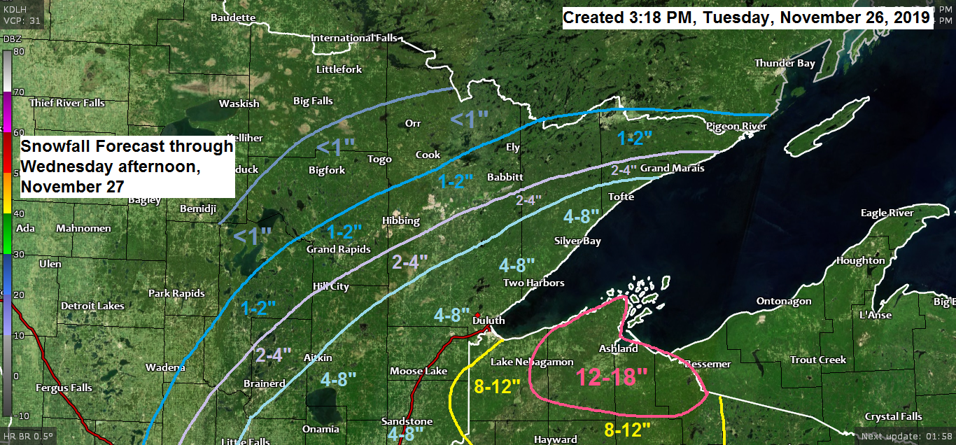
Here’s my updated snowfall forecast.
Tightened up the snowfall gradients compared to 24 hours ago.
Anywhere from 8 to 18 inches of snow across most of northwest Wisconsin, greatest amounts along the South Shore including the Bayfield, Ashland and Gile areas.
Snowfall of 4 to 8 inches along the North Shore south to the Twin Ports and I-35 corridor, west toward Aitkin.
2 to 4 inches of snow from Grand Marais to Hill City to Brainerd.
1 to 2 inches of snow for Ely, Hibbing, Grand Rapids and Longville.
Less than an inch of snow from Orr to Bigfork to Walker.
Not expecting any snow from this storm along the Borderland, including for International Falls.
Note: There is still some uncertainty even at this late hour on how far west the heavier snow will get, it’s possible the corridor from Brainerd to Hibbing to Grand Marais may get a little more snow than what I’m forecasting.

| Links to Road Conditions Minnesota: https://lb.511mn.org/ Wisconsin: https://511wi.gov/ Links to Power Outage maps Minnesota Power: https://www.mnpower.com/OutageCenter/OutageMap Lake Country Power: http://outage.lcp.coop/#viewer-menu-parent | |
Two powerful storms out there today, one is lifting northeast across the Plains while the other one crashes onto the U.S. West Coast today.
Source: Goes-16 water vapor imagery; https://weather.cod.edu/

Low temperature forecast for Wednesday morning, November 27. Source: https://graphical.weather.gov/

High temperature forecast for Wednesday, November 27.

Forecast for Duluth and Superior
*Winter Storm Warning* 9 PM this evening to Noon Wednesday.
*Lakeshore Flood Warning* Midnight tonight to 3 PM Wednesday.
-Scattered lake effect snow showers this evening possibly mixed with sleet. Patchy drizzle/freezing drizzle also possible.
-Steadier snow arrives overnight (~11 PM-2 AM)
-Snow continues through Wednesday morning, gradually tapering off mid to late Wednesday afternoon.
-Gusty northeast winds tonight at 15 to 30 mph (gusts to 45 mph possible late) Winds become north on Wednesday at 15 to 30 mph.
-Areas of blowing snow tonight into Wednesday.
-Travel will become very difficult late tonight through at least early Wednesday afternoon.
-Total snowfall accumulations of 4 to 8 inches.
Note: Another winter storm could affect parts of the Northland this weekend with a prolonged snow event possible beginning on Friday and not ending until sometime on Sunday. Lake effect/enhanced snowfall is also possible near Lake Superior, especially along the North Shore. Mixed precipitation is also possible with this storm. Stay tuned!
Thanks for reading!
Leave a Reply