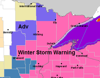
-Winter Storm Warning (pink area on map below) covers all of northwest Wisconsin, and now includes parts of northeast and east-central Minnesota from the Arrowhead and North Shore south to Duluth, I-35 corridor, west to the Brainerd Lakes. The warning is in effect from this evening through the day Wednesday. Heavy snow and strong winds are expected in the warning area with very difficult travel conditions possible.
-Winter Weather Advisory (purple area on map below) covers portions of northeast and north-central Minnesota including the Walker, Grand Rapids, Bigfork and Orr areas. The advisory is in effect from this evening through Noon Wednesday.
Source: https://www.weather.gov/dlh/

Lakeshore Flood Warning has been issued for the South Shore of Lake Superior including the Twin Ports for late tonight through Wednesday.
Strong north to northeast winds will cause waves to build to between 6 and 17 feet tonight into Wednesday which may lead to lakeshore flooding.
Beach erosion and flooding are possible along the South Shore of Lake Superior.

Not going to make any changes to my snowfall forecast early this Tuesday morning, but I may need to adjust the totals just a bit, but I’ll wait until later today to do that if need be. Wanna see a few more model runs through the day before making any changes.

For Duluth and Superior
*Winter Storm Warning* in effect from 9 PM this evening to Noon Wednesday.
*Lakeshore Flood Warning* in effect from Midnight tonight to 3 PM Wednesday.
Most of today should be dry in the Twin Ports, but some light lake effect snow or patchy freezing drizzle is possible later this afternoon into this evening as winds shift and increase out of the east-northeast.
Steadier and heavier snow arrives later this evening (~10 PM to 1 AM)
Snow continues into early Wednesday afternoon before tapering off later Wednesday afternoon.
Strong northeast winds 20 to 30 mph this evening through the Overnight with gusts to 45 mph.
Areas of blowing snow late tonight into Wednesday.
4 to 8 inches of snow are possible in the Twin Ports by Wednesday afternoon with higher amounts possible.
More updates later today.
Thanks for reading!
Leave a Reply