7.0 inches of snow at the Duluth Airport today, 3rd snowiest November 27th on record. Snowiest November 27th occurred in 1994 with 12.4 inches of snow.
Winter Storm Potential for this weekend
Map below shows two possible storm tracks.
Track one is most favorable for significant amounts of snow in the Northland while track two would be less favorable for significant snow in the Northland. Computer models have been leaning toward the northern track (number 1) or somewhere between the two tracks shown on the map.
Note: Lake effect or lake enhanced snow is also possible with this event with east to northeast winds from Friday through Sunday morning, the combination of system snow plus any lake effect snow that may develop could lead to snowfall totals getting into the 12 to 24″ range near Lake Superior. Those east winds will also be on the gusty side (15 to 30 mph, gusts to 40 mph) Friday night through Sunday morning.

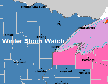
Winter Storm Warning (pink area) until 8 PM this evening for the South Shore of Lake Superior including Superior, Bayfield, Ashland, Hurley and Gile.
Winter Storm Watch (blue area) from Friday evening through Sunday afternoon, this watch includes the city of Duluth.

Radar forecast valid from 7 AM Thursday to Midnight Saturday.
This model shows a few lake effect snow showers near Lake Superior on Thursday followed by some light snow on Friday.
Source: 18z NAM-WRF model; https://weathermodels.com/

Low temperature forecast for Thursday morning, November 28. Source: https://graphical.weather.gov/

High temperature forecast for Thursday, November 28.

Additional Snowfall Reports from Wednesday, November 27, 2019. Source: https://www.weather.gov/dlh/
4.1 ENE Cornucopia, WI: 15.5″ 2 SSW Poplar, WI: 12.0″ 7 ESE Superior, WI: 10.4″ 3 N Mahtowa, MN: 10.3″ Holyoke, MN: 9.5″ 2 NNW Mellen, WI: 9.2″ 5 NNE Brule, WI: 9.0″ Grand View, WI: 8.5″ Ashland, WI: 7.1″ Duluth Airport: 7.0″ 7 NNW Two Harbors, MN: 7.0″ 2 SSW Moose Lake, MN: 6.5″ 3 SSW Bruno, MN: 6.5″ 7 W Hovland, MN: 6.0″ 6 ENE Rice Lake, MN: 6.0″ 4 SSE Webster, WI: 3.0″ 3 N Brainerd, MN: 2.5″ Grand Rapids, MN: 2.0″ | |
…Weather Summary…
Quieter weather returns tonight and Thanksgiving as strong high pressure settles into the upper Midwest behind today’s winter storm.
Mostly cloudy skies this evening with areas of light snow and flurries will give way to partly to mostly cloudy skies overnight while some lake effect snow showers develop along the South Shore, mainly affecting parts of Bayfield, Ashland and Iron Counties.
A wide range in low temperatures tonight with single digits to near zero degree temps where skies clear a bit while teens and 20s will be common where skies remain mostly cloudy. Winds tonight will be out of the north at 5 to 15 mph with gusts of 20 to 35 mph continuing this evening.
Highs on Thanksgiving are forecast to be in the 20s to lower 30s under partly to mostly cloudy skies. Winds will be out of the north or east at 5 to 15 mph. There could be some lake effect snow showers on Thursday shifting from the South Shore to the North Shore as winds shift from north to the east, but little if any accumulation is expected the way it looks now.
Friday through Sunday could be snowy at times as a strong and large low pressure system moves slowly east out of the Rockies. This system has the potential to produce significant impacts from snow, mixed precipitation, gusty winds to blowing snow.
A prolonged period of east-northeast winds are also expected to setup from Friday through Sunday morning with long trajectories coming down Lake Superior, this could cause very heavy lake enhanced or lake effect snow to develop especially along the North Shore this weekend with feet of snow possible if everything comes together. The strong east winds would also cause a significant amount of blowing snow over the weekend.
Forecast for Duluth and Superior
*Winter Storm Warning* for Superior until 8 PM this evening.
*Winter Storm Watch* for Duluth from Friday evening through Sunday afternoon.
.Tonight… Mostly cloudy with some clearing late. Breezy this evening with patchy blowing snow. Flurries this evening. Low 10 to 15. Wind north 5 to 15 mph with gusts 15 to 30 mph this evening.
.Thanksgiving Day… A few light snow showers and flurries otherwise partly sunny. High 27 to 31. Wind becoming east 5 to 15 mph.
.Friday… Mostly cloudy. Some light snow possible. High 30 to 33. Wind east 10 to 20 mph.
| Normal temperatures for November 28 High 29 Low 15 Sunrise Thursday 7:29 AM CST Sunset Thursday 4:24 PM CST | |
Thanks for reading!
Leave a Reply