Widespread winter weather alerts are in effect through Sunday as the next winter storm takes aim at the Northern Plains and upper Midwest.
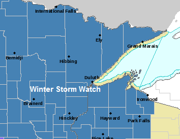
| Red – Blizzard Warning Pink – Winter Storm Warning Blue – Winter Storm Watch Purple – Winter Weather Advisory | |
Source: https://www.pivotalweather.com/

Winter Storm Watch (blue area on map) for the entire Northland from Friday evening through Sunday afternoon.
Travel could be very difficult Saturday through Sunday afternoon due to snow, gusty winds, blowing snow and possibly some mixed precipitation.
Source: https://www.weather.gov/dlh/

Lakeshore Flood Watch in effect from Saturday afternoon through Sunday afternoon for southern St. Louis, Carlton and Douglas Counties.
Lakeshore flooding is possible especially in Canal Park and other low lying shoreline areas. Beach and shoreline erosion is also possible as wave heights build to 10 feet or more.

Here’s my preliminary snowfall forecast for this weekend’s storm.
Lowest amounts (1-3″) in far northern Minnesota, International Falls and Littlefork areas.
3-6″ of snow for Bigfork, Hibbing, Ely and Grand Marais.
6-10″ of snow (higher amounts possible) farther south, including Walker, Grand Rapids, Brainerd, Aitkin, Moose Lake and Hayward.
12-24″ of snow near Lake Superior, including from Duluth to Silver Bay, and from near Port Wing to Bayfield to Ashland.
Note: Adjustments to the snowfall totals and gradients are possible over the next 24 hours, stay tuned.

Outlook for Duluth and Superior
-Patchy flurries, light snow showers and possibly some freezing drizzle for the rest of today into tonight.
-Some light snow, flurries and patchy freezing drizzle is possible at times on Friday. Snowfall accumulations of less than an inch through Friday evening.
-Steadier snow is expected to begin either late Friday night or during the day Saturday, snow is then forecast to continue into Saturday night and Sunday morning.
-Winds becoming east this afternoon at 5 to 15 mph. East winds tonight and Friday 10 to 20 mph.
-Strong east to northeast winds 20 to 35 mph Friday night through Sunday morning with gusts to 45 mph.
-Snow that falls this weekend should be of the wet variety as temps range from around 30 to 33 degrees.
Thanks for reading!
Leave a Reply