-Winter Weather Advisory in effect until 4 PM Thursday for the North Shore of Lake Superior including the cities of Two Harbors, Isabella, Finland, Silver Bay, Tofte and Grand Marais.
-Winter Weather Advisory for parts of northwest Wisconsin in effect from 8 AM to 6 PM Thursday including the cities of Port Wing, Washburn, Bayfield, Ashland, Hurley and Gile.
-Plan on slippery road conditions in the advisory areas. The hazardous conditions could impact the Thursday morning and evening commutes.
-A light glaze of ice accumulation is expected on Thursday in northern Wisconsin along with light snowfall accumulations.
-Snow accumulations ranging from 2 to 6 inches are likely along the North Shore of Lake Superior.

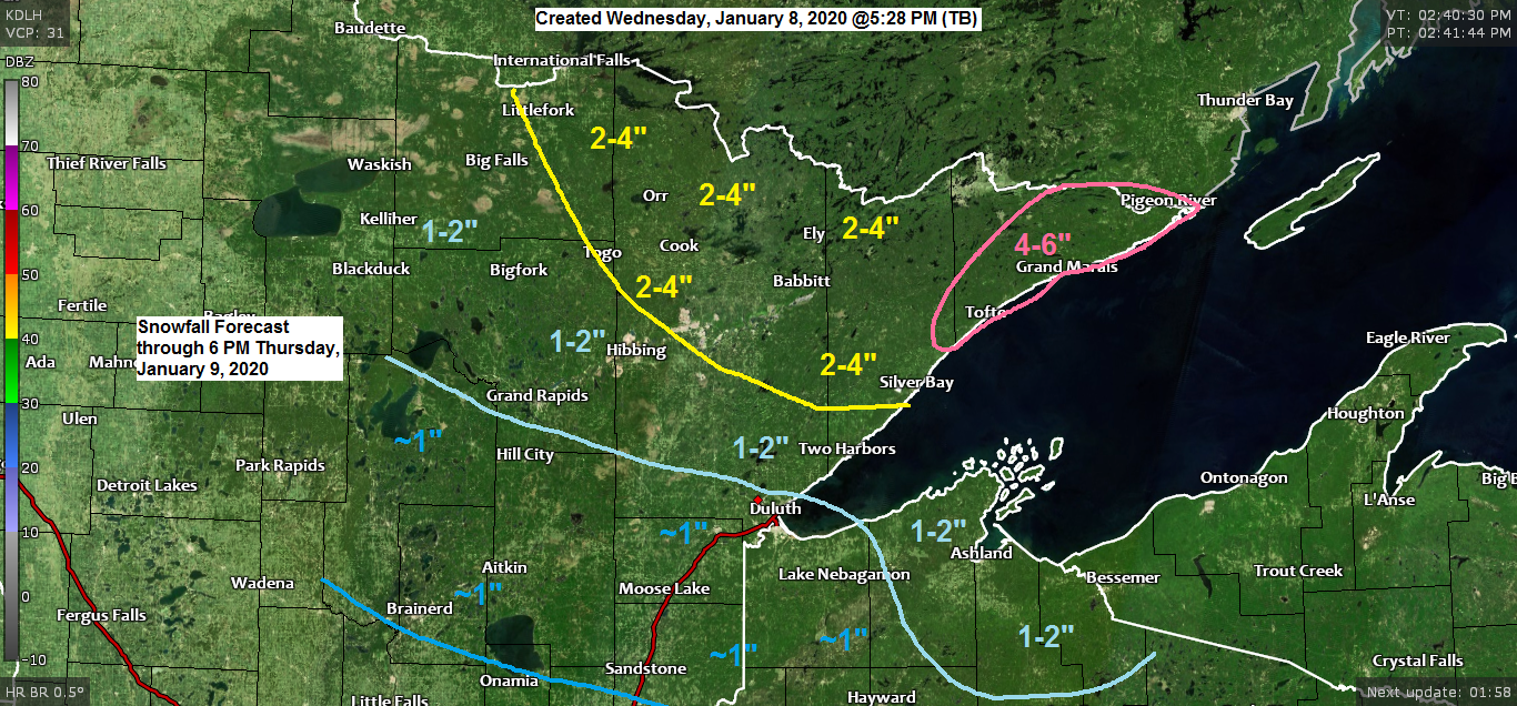
Here’s my snowfall forecast ending at 6 PM Thursday.
*4 to 6 inches of snow in the tip of the Arrowhead including Tofte and Grand Marais.
*2 to 4 inches of snow for International Falls, Cook, Ely and Silver Bay.
*1 to 2 inches of snow for Bigfork, Grand Rapids, Hibbing, Two Harbors, Bayfield, Ashland and Hurley.
*Around an inch of snow for Hill City, Brainerd, Aitkin, Duluth, Superior, Solon Springs, Moose Lake, Sandstone and Hayward.

Should have quite a temperature contrast in place on Thursday with teens in northwest Minnesota and 40s in southern Minnesota.
Source 12z European computer model 1.8.2020; https://weathermodels.com/

I’m keeping an eye on the potential for some lake effect snow this weekend. Computer models are starting to agree on the pattern with winds shifting to the east-northeast Saturday into Sunday, this combined with cold air in place and pretty much a wide open lake due to the lack of ice cover could cause lake effect snow showers to affect areas near Lake Superior. Whether this will be a significant lake effect event, or just a minor event is uncertain at this time. Stay tuned.

Some serious cold is forecast to spill into western Canada and the northern Rockies next week with some of that big time cold air possibly pushing far enough to the south/east to impact the upper Midwest sometime mid to late next week.
Source 12z European ensemble model 1.8.2020; https://weathermodels.com/

Low temperature forecast for Thursday morning, January 9, 2020. Source https://graphical.weather.gov/

High temperature forecast for Thursday, January 9.

| Low temperature reports from around the Northland from Wednesday morning, January 8, 2020. Source https://www.weather.gov/dlh/ Kabetogama, MN: -30F International Falls, MN: -29F Cotton, MN: -27F Bigfork, MN: -27F Crane Lake, MN: -26F Cook, MN: -26F Orr, MN: -26F Embarrass, MN: -25F Littlefork, MN: -25F Babbitt, MN: -24F Cass Lake, MN: -22F Chisholm-Hibbing Airport: -22F Northome, MN: -21F Walker, MN: -21F Hill City, MN: -20F Aitkin, MN: -20F Ely, MN: -20F Grand Rapids, MN: -19F Solon Springs, WI: -17F Minong, WI: -16F Clam Lake, WI: -15F Brainerd, MN: -15F Duluth Airport: -12F | |
…Weather Summary…
Arctic airmass will be retreating off to the east this evening and this will be replaced by strong warm air advection and a period of snow tonight as low pressure and a warm front move E-NE out of the Northern Plains.
This same low, warm front and a cold front will pass through the area on Thursday bringing with it some more light snow at times.
Warmer air lifting NE ahead of this system will cause some freezing drizzle/freezing rain on Thursday in parts of northern Wisconsin and possibly in eastern Minnesota as well.
Highs Thursday in the 20s to lower 30s.
South or east winds tonight and Thursday at 10 to 20 mph.
Note: Cold, arctic air returns Friday, but this also doesn’t look to stick around very long as the most persistent arctic air remains bottled up farther to the NW through early next week. The weather pattern does look somewhat active, however, with several shots for some snow this weekend into next week.
Forecast for Duluth and Superior
.Tonight… A period of light snow possible mainly before Midnight. Accumulations of an inch or less. Mostly cloudy. Temperatures rising into the teens. Wind east to southeast 10 to 20 mph.
.Thursday… Milder. Mostly cloudy. Some light snow possible at times especially during the afternoon. Patchy freezing drizzle also possible. High 25 to 30. wind east to southeast 10 to 20 mph becoming west late in the day.
.Friday… Partly to mostly cloudy. High 10 to 15. Wind northwest 10 to 20 mph.
| Normal temperatures for January 9 High 19 Low 2 Sunrise Thursday 7:53 AM CST Sunset Thursday 4:39 PM CST | |
Thanks for reading!
Tim
Leave a Reply