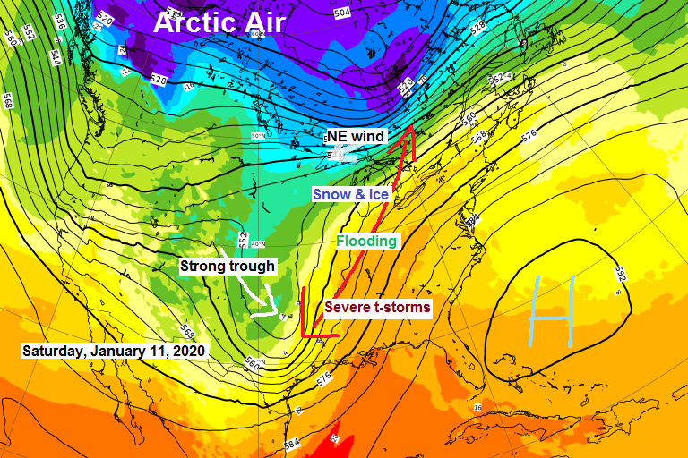
A strong storm will be impacting the Midwest and Great Lakes Friday through early Sunday morning with a flood and severe threat on the warm side of the storm and a snow/ice threat on the cold side of the storm.
Winter Storm Watches in blue; Flood Watches in green.
Source https://home.pivotalweather.com/

This weekend’s storm will also bring the first widespread significant severe threat of 2020 to portions of the Southern Plains and Southern Mississippi Valley region with widespread damaging winds and tornadoes expected Friday and Saturday.
Friday’s outlook shows a moderate (red) and enhanced (orange) risk for severe thunderstorms.
Source https://kamala.cod.edu/SPC/

Saturday’s severe threat shifts a bit more to the east with a continued enhanced risk (orange)

Although this weekend’s storm will miss the Northland it will help turn the winds to the east/northeast Saturday into Sunday, this combined with a cold airmass over the area and very little ice coverage over Lake Superior should cause some lake effect snow to develop this weekend which will impact the North Shore and South Shore of Lake Superior including in Duluth and Superior.
Source 12z European computer model 1.9.2020; https://www.ecmwf.int/

Look at this temperature contrast for Saturday morning, ranging from the 20s below in eastern North Dakota and northwest Minnesota to around 60 ABOVE ZERO as far north as north-central Indiana.
Source 12z RGEM model 1.9.2020; https://www.tropicaltidbits.com/

Low temperature forecast for Friday morning, January 10, 2020. Source https://graphical.weather.gov/

High temperature forecast for Friday, January 10.

| Snowfall Reports from around the Northland from January 9, 2020 Source https://www.weather.gov/dlh/ 2 SSW Kabetogama, MN: 2.0″ 1 W Silver Bay, MN: 1.2″ 4 W Grand Marais, MN: 1.1″ 2 E Celina, MN: 1.0″ 1 SE Ely, MN: 0.9″ Duluth Airport: 0.2″ International Falls, MN: 0.2″ | |
…Weather Summary…
A reinforcing shot of cold, arctic air will move into the Northland the next few days.
High pressure builds SE into the Northern Plains Friday behind today’s system which brought a bit of snow and freezing drizzle to the Northland.
Mostly cloudy skies tonight with some clearing later on. Lows will range from the single digits below zero to the lower teens above zero with winds becoming northwest at 10 to 20 mph.
Partly to mostly cloudy skies on Friday with highs in the single digits and teens. Winds will be out of the northwest at 10 to 20 mph.
A major storm misses us to the SE over the weekend, but could clip far eastern portions of northwest Wisconsin with some snow late Saturday into early Sunday, roughly along and east of an Ashland to Hayward line.
Winds will shift to the east/northeast this weekend between a strong low to the SE and high pressure to the NE. Winds could become quite gusty near Lake Superior Saturday afternoon into Sunday morning (wind gusts 20-25 mph) the lake is pretty much wide open with only 0.5% ice coverage as of January 9th so I think will see some lake effect snow bands setup near Lake Superior Saturday and Sunday especially considering the colder temps aloft of around -15C at the 850mb level, that is plenty cold to get the lake machine cranking. Still not real sure though if this will be a significant lake effect snow event, or just a minor snow event. Stay tuned.
Note: A few more systems are lined up for next week with shots of accumulating snow possible in the Northland depending on the tracks of these systems.
Forecast for Duluth and Superior
.Tonight… Mostly cloudy with flurries or patchy freezing drizzle this evening. Some clearing late. Low 5 to 10. Wind becoming northwest 10 to 20 mph.
.Friday… Partly to mostly cloudy. High 10 to 15. Wind northwest 10 to 20 mph.
.Saturday… Partly to mostly cloudy. Becoming breezy. Some snow possible. High 15 to 20. Wind becoming east to northeast 5 to 15 mph with gusts to 25 mph later in the day.
| Normal temperatures for January 10 High 19 Low 1 Sunrise Friday 7:52 AM CST Sunset Friday 4:40 PM CST | |
Thanks for reading!
Tim
Leave a Reply