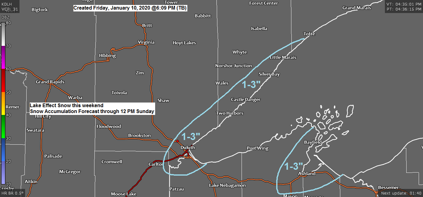
Should see some lake effect snow bands develop over western Lake Superior Saturday and Sunday with plenty of cold air in place along with a wide open lake. Wind direction will determine where these snow bands setup over the weekend, and as is usually the case with lake effect snow, if a more persistent/heavier snow band sits over the same location for a few hours, snow totals could be much higher than what I have in my forecast as this should be a fluffy snow, it will pile up quickly if it snows hard enough.

18z NAM-WRF model radar forecast valid from 6 AM Saturday to 1 AM Monday.
Lake effect snow showers along the South Shore Saturday into Sunday morning while lake effect snow showers gradually develop along the North Shore Saturday PM into Sunday, then we could see a period of light synoptic type snowfall spread NE across the area Sunday night-Monday morning.

-Wind Chill Advisory in effect from Midnight tonight to 9 AM Saturday for northern Minnesota including the cities of International Falls, Bigfork, Grand Rapids, Walker, Brainerd, Hill City, Hibbing, Cook, Ely and Isabella.
-Wind chills as low as 30 below zero.
-The cold wind chills could cause frostbite on exposed skin in as little as 30 minutes.
Source https://www.weather.gov/dlh/

Source https://weathermodels.com/
Next week looks active! A pool of cold, arctic air will be in place over western Canada into the Northern Rockies while a large area of well above normal temperatures covers the southern/eastern US — Several low pressure systems could develop and track E-NE out of the Rockies and Plains next week, between the arctic and warm airmasses. If these systems track far enough north then we could see frequent snowfalls across the Northland next week. Stay tuned.
Source 12z European ensemble model 1.10.2020; https://weathermodels.com/

A wetter bias showing up in long range model guidance through late January across northeast Minnesota and northwest Wisconsin, could be dealing with a snowy pattern mid to late month.
Source 12z European ensemble model

A powerful storm is affecting much of the Midwest, Great Lakes and Southern Plains tonight and Saturday.
Flooding and severe weather on the warm side of the storm, snow and ice on the cold side of the storm.
Winter Storm Warning (pink)
Flood warnings (green)
Tornado Watch (yellow)
Source https://www.pivotalweather.com/

Here’s how today’s storm looks on Goes-16 infrared satellite imagery.
Severe weather blowing up over the Southern Plains today with 20 severe weather reports through 4 PM Friday including 2 reports of tornadoes, one in southwest Missouri, the other in northeast Oklahoma.
Source https://weather.cod.edu/

Low temperature forecast for Saturday morning, January 11, 2020. Source https://graphical.weather.gov/

High temperature forecast for Saturday, January 11.

…Weather Summary…
Low pressure was over north-central Texas at 5 PM Friday with arctic high pressure over the Northern Plains. Cold air was spilling into the Northland today with 850mb temperatures of -10 to -18C.
A quiet but cold night ahead under partly cloudy skies. Lows will range from the teens and 20s below in northern Minnesota to the single digits below to around 10 above zero in northwest Wisconsin.
Partly to mostly cloudy skies on Saturday as strong arctic high pressure builds into Ontario while low pressure moves quickly from eastern Arkansas Saturday morning to near Lake Huron by Sunday morning. Highs on Saturday will range from the single digits to the teens with north or east winds 5 to 15, but stronger gusts are possible near Lake Superior Saturday afternoon into Saturday night.
Lake effect snow showers should develop Saturday morning along the South Shore with winds out of the north, then as winds shift to the northeast/east, lake effect snow showers will shift west impacting the Twin Ports and North Shore Saturday afternoon into Sunday morning.
Lake effect snow showers could continue Sunday, but with winds turning more to the E-SE, the threat for lake effect should shift north of Duluth.
Another round of light snow is possible in parts of the Northland Sunday afternoon into Sunday night, and more snow events are possible at times through next week.
Forecast for Duluth and Superior
.Tonight… Partly to mostly cloudy. Cold. Low 4 below to 9 below. Wind northwest 5 to 15 mph with gusts to 20 mph.
.Saturday… Partly to mostly cloudy. Becoming breezy late. Occasional snow showers possible. High 10 to 15. Wind north 5 to 15 mph becoming east to northeast 10 to 20 mph with gusts to 25 mph.
.Saturday night… Breezy. Occasional snow showers. Patchy blowing snow. Low 10 to 15. Wind northeast 10 to 20 mph with gusts to 25 mph. Total snowfall accumulations of 1 to 3 inches possible.
.Sunday… Partly to mostly cloudy. Snow showers or flurries possible. High 17 to 22. Wind east to southeast 5 to 15 mph.
| Normal temperatures for January 11 High 19 Low 1 Sunrise Saturday 7:52 AM CST Sunset Saturday 4:42 PM CST | |
Thanks for reading!
Tim

Leave a Reply