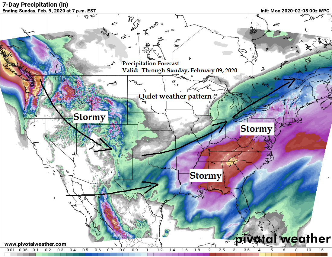
Looks pretty quiet in the Northland this week as all the major weather systems pass well south and east of our area.
Source: https://www.pivotalweather.com/

One heck of a jet stream over the Northern tier of the U.S. today.
A strong trough is digging S-SE out of the Pacific NW today while another system lifts NE out of the Baja region.
Source: RAP model; https://www.spc.noaa.gov/

Goes-16 water vapor loop from Sunday, February 2, 2020.
Source: https://weather.cod.edu/

Those 70s sure look nice! A mild to warm winter day across the Plains and upper Midwest today.
Source: RTMA model; https://lab.weathermodels.com/

A cooling trend is on the way for the Northland, but more or less just closer to where we should be at this time of year, no more 30s or 40s this week.
Source: 12z European ensemble model 2.2.20; https://weathermodels.com/

Low temperature forecast for Monday morning, February 3, 2020. Source: https://graphical.weather.gov/

High temperature forecast for Monday, February 3, 2020.

| Temperature and Precipitation report for Duluth, Minnesota for the week of January 26th, 2020. High Temperatures/Departure from Normal 1.26: 28F/+9 degrees above normal 1.27: 24F/+4 degrees above normal 1.28: 20F/Normal 1.29: 24F/+4 degrees above normal 1.30: 21F/+1 degree above normal 1.31: 29F/+9 degrees above normal 2.1: 33F/+13 degrees above normal Low Temperatures/Departure from Normal 1.26: 24F/+23 degrees above normal 1.27: 14F/+12 degrees above normal 1.28: 12F/+10 degrees above normal 1.29: 18F/+16 degrees above normal 1.30: 17F/+15 degrees above normal 1.31: 19F/+17 degrees above normal 2.1: 25F/+23 degrees above normal Note: Average temperature in Duluth for the week of January 26th: 22.0 degrees; +11.2 degrees above normal. Source: https://www.dnr.state.mn.us/ Total Precipitation: Trace Normal: 0.17″ Departure: -0.17″ below normal State Average for Minnesota for the week of January 26, 2020. Temperature: 20.9 degrees Departure: +8.7 degrees above normal Precipitation: 0.04″ Departure: -0.12″ below normal |
Average temperature, departure from mean for the week of January 26th, 2020. Source: https://mrcc.illinois.edu/

Total precipitation, departure from mean for the week of January 26th, 2020.

…Weather Summary…
The big weather story the next few days will be the return of a colder airmass, likely peaking on Tuesday when 850mb temperatures fall to around -15 to -20C.
One cold front moved through the area early today which is one of the reasons why temperatures didn’t get much warmer than the middle 30s or lower 40s. Warmest air was over us early this morning, before sunrise, then we had cold air advection pouring into the Northland already before Noon which kept temps fairly steady or even falling a bit this afternoon.
Will see another cold front move through the Northland on Monday, but not expecting any precipitation with this front.
Partly to mostly cloudy skies are expected through Tuesday with scattered flurries possible.
Lows tonight will be in the teens to lower 20s with single digits possible in northern Minnesota. Winds will shift from the northwest to west-southwest at 5 to 15 mph with gusts to 25 mph.
Highs on Monday will be in the teens and 20s with northwest winds 10 to 20 mph.
Subzero temperatures are possible over parts of the Northland Monday night and again Tuesday night.
| Highest Wind Reports from around the Northland from Sunday, February 2, 2020 Source: https://www.weather.gov/dlh/ Blatnik Bridge: 53 mph Duluth Airport: 45 mph Duluth Harbor: 40 mph Clouqet, MN: 38 mph Chisholm-Hibbing Airport: 37 mph Superior Airport: 37 mph Moose Lake, MN: 35 mph Two Harbors, MN: 33 mph Minong, WI: 33 mph Brainerd, MN: 32 mph Grand Rapids, MN: 32 mph Solon Springs, WI: 32 mph Walker, MN: 31 mph |
Forecast for Duluth and Superior
.Tonight… Breezy. Partly to mostly cloudy. Low 15 to 20. Wind west to northwest 10 to 20 mph.
.Monday… Partly to mostly cloudy. Cooler. High 22 to 27. Wind northwest 10 to 20 mph.
.Tuesday… Partly to mostly cloudy. High 12 to 17. Wind northwest 10 to 20 mph.
| Normal temperatures for February 3 High 21 Low 3 Sunrise Monday 7:31 AM CST Sunset Monday 5:14 PM CST |
Thanks for reading!
Tim
Leave a Reply