A few days ago, a meteorologist at the National Weather Service in Duluth used the word “humdrum” in one of their forecast discussions to describe our weather pattern as of late, and well I would have to agree with that after looking over the long range computer models, as a dry/fairly quiet weather pattern looks to continue around here looking out the next 2 weeks.
For the most part, this winter has been a quiet one. Sure there’s been quite a few minor and the occasional moderate snow event sprinkled in since December, but for the most part this winter has been on the boring side of things, yes we had that powerful post-Thanksgiving weekend blizzard, but not much after that when it comes to a major winter storm hitting the Northland, however this winter is still running above normal in snowfall across the Northland which is a little interesting.
Source: 12z European ensemble model 2.18.2020; https://weathermodels.com/

Long range computer models have changed considerably for next week, yes I realize models change daily, but this is one of the bigger changes I’ve seen in a while.
Threat for a storm impacting the Northland next week has pretty much disappeared in the GFS and Euro models today as the storm track remains well south of our area.
Shown below is the 50 member European ensemble (EPS) snowfall forecast for Duluth through March 4th. Check out the spread in snowfall totals for Duluth as we get into late next week, this shows the spread in the EPS model and its members, as some members still show quite a bit of snow in Duluth late next week, others show nothing.
Source: https://weathermodels.com/

The late week warm-up is still on track as a nice ridge builds SE into the upper Midwest, but there are signs showing up in long range model guidance for a flip to colder conditions once again by mid to late next week.
Source: 12z Euorpean ensemble model 2.18.2020

| Meteorological Winter 2019-2020 Snowfall Totals from December 1st to February 17th Duluth, MN: 50.3″ (+6.2″ above normal) Last winter thru February 17th: 59.0″ International Falls, MN: 42.7″ (+6.2″ above normal) Last winter thru February 17th: 37.1″ Brainerd, MN: 27.8″ (+4.7″ above normal) Last winter thru February 17th: 41.8″ |
Accumulated Snowfall for the winter of 2019-2020 thru February 17th. Source: https://mrcc.illinois.edu/

Accumulated Snowfall, percent of mean for the winter of 2019-2020 thru February 17th.

| February 2020 Climate Stats for Duluth, Minnesota thru the 17th. Average temperature: 13.0 degrees Departure: -0.3 degrees below normal 5 nights with a subzero temperature Average for February is 11 nights 2 days with a temperature warmer than 32F Average for February is 6 days Total Precipitation: 0.17″ Departure: -0.25″ below normal Total Snowfall: 4.9″ Departure: -2.1″ below normal Note: Last February was the snowiest February on record in Duluth with 36.4″ of snow, records for Duluth go back to 1875. A lot less snow so far this February. |
Average temperature, departure from mean for February 2020 thru the 17th. Source: https://mrcc.illinois.edu/

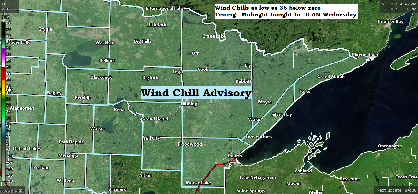
-Wind Chill Advisory in effect from Midnight tonight to 10 AM Wednesday for northern and northeastern Minnesota including the North Shore of Lake Superior (light blue area on map)
-Some cities included in the advisory are International Falls, Bigfork, Grand Rapids, Walker, Hibbing, Cook, Ely, Isabella, Grand Marais, Silver Bay, Two Harbors, Duluth, Cloquet and Moose Lake.
-Wind chills as low as 35 below zero.
-The cold wind chills could cause frostbite on exposed skin in as little as 30 minutes.

Arctic air mass will remain over the Northland through Thursday morning, but will begin to see some improvement by Thursday afternoon, but more so on Friday.
Source: RAP model; https://www.spc.noaa.gov/

Low temperature forecast for Wednesday morning, February 19th, 2020. Source: https://graphical.weather.gov/

High temperature forecast for Wednesday, February 19th, 2020.

…Weather Summary…
Cold, arctic air will be over the Northland through Thursday as high pressure moves SE across the area.
Clear to partly cloudy skies through Thursday. Lows tonight and Wednesday night in the single digits, teens and 20s below zero with highs Wednesday in the single digits to lower teens, highs on Thursday in the teens to lower 20s.
Milder, Pacific air moves in on Friday which should then stick around through the weekend. Highs on Friday, Saturday and Sunday are forecast to be in the 30s with some locations climbing into the 40s especially Saturday and Sunday.
Forecast for Duluth and Superior
*Wind Chill Advisory in effect from Midnight tonight to 10 AM Wednesday*
.Tonight… Very cold. Blustery. Mostly clear. Low 7 below to 12 below. Wind west to northwest 10 to 20 mph. Wind chills as low as 35 below zero overnight.
.Wednesday… Cold. Sunshine. High 6 to 10. Wind northwest 10 to 15 mph. Morning wind chills as low as 35 below zero.
.Thursday… Mostly sunny. High 14 to 19. Wind southwest 10 to 20 mph.
| Normal temperatures for February 19 High 25 Low 7 Sunrise Wednesday 7:07 AM CST Sunset Wednesday 5:39 PM CST |
Thanks for reading!
Tim
Leave a Reply