Last night’s storm packed a punch with heavy wet snow, gusty winds and thunderstorms in northeast Minnesota and far northwest Wisconsin.
-As of 6 PM Sunday, Minnesota Power reported 114 active outages in their service area affecting over 4000 customers – Link to Minnesota Power Outage Map https://www.mnpower.com/OutageCenter/OutageMap
-Lake Country Power is reporting nearly 5800 members are without power as of late Sunday afternoon – Link to Lake Country Power Outage Map http://outage.lcp.coop/#viewer-menu-parent
-Thundersnow occurrred in Duluth and other parts of the area late Saturday evening (radar image below was from 11:45 PM Saturday) note the lightning strikes over Duluth, and south of Oliver. Snowfall rates of 1-2″ per hour occurred as this band of convection/very heavy snow moved through. I counted 3 flashes of lightning at my location in West Duluth late Saturday evening, amazing stuff as thundersnow is actually quite rare, even for this area.
-Saturday night’s winter storm was quite similar to a storm we had in Duluth last May on the 8th, that one also brought thundersnow to the Twin Ports and dumped around 10″ of heavy wet snow at the Duluth Airport.
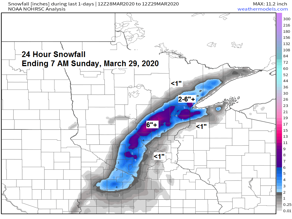
-Elevation played a big role on snowfall totals Saturday night-Sunday morning, March 28-29, 2020 with a lot less snow next to Lake Superior in lower elevation areas, while significant amounts of heavy wet snow occurred in higher elevated areas, this was also the case with the winter storm last May.

Saturday’s mid latitude cyclone shows up well by all the lightning strikes that it produced from the Southern US to Ohio Valley into parts of the upper Midwest and Great Lakes (orange, red and purple colors on map)
Source: https://www.lightningmaps.org/

Source: https://lab.weathermodels.com/

-This was my final snowfall forecast I released Saturday afternoon for last night’s storm (see map below) Overall I’d call it a pretty good forecast, except for having the 7-12″ and 3-7″ zones way too far east in northwest Wisconsin, and I’ve yet to see any reports of snowfall over 8″ in the 7-12″ zone, so I was too high on snowfall totals in that area, but some locations were within the range, so again not too bad.
-I also didn’t have the heavier snow far enough southwest, so that was a big miss as Garrison picked up 5.5″ of snow (Garrison is located southwest of Aitkin) my forecast was for <1″ of snow for that area.
-Duluth Airport’s snowfall total was around 6″ – forecast was for 3 to 7″, so the Airport hit the high end of that range.
Note: All of these winter storms are difficult to forecast, especially the ones that hit early in the season, and the ones that hit in the spring. Temperatures with last night’s storm were marginal for snow, it all came down to whether or not we’d get strong enough lift in the atmosphere and enough dynamic cooling to take place to produce a changeover from rain to snow, and that did happen in parts of the area, thanks in part to the thunderstorms that moved through late last evening which helped to cool the column to produce snow. There’s always going to be a few misses in a snowfall forecast, either by forecasting too much snow, or too little snow in a given location, that’s just how it works with weather forecasting, nothing will be 100% perfect.

| Snowfall Reports from around the Northland for March 28-29, 2020 Source: https://www.weather.gov/dlh/ Lyman Lake, WI: ~8.0″ (Facebook report) 7.8 E Patzau, WI: 7.8″ 9.7 SSE Wrenshall, MN: 7.5″ 7 N McGregor, MN: 5.9″ Duluth Airport: 5.8″ 3 N Mahtowa, MN: 5.5″ Garrison, MN: 5.5″ 3.4 ENE Cloquet, MN: 5.0″ 7 NNW Two Harbors, MN: 4.8″ Willow River, MN: 4.5″ Kettle River, MN: 4.3″ 3 SSE South Range, WI: 4.3″ Moose Lake, MN: 4.0″ 1 S Twig, MN: 4.0″ 1 NNE Cloquet, MN: 3.4″ 1 SSW Oulu, WI: 3.0″ 2 E Poplar, WI: 2.9″ 7 ESE Superior, WI: 2.4″ Silver Bay, MN: 2.0″ Two Harbors, MN: 2.0″ Gilbert, MN: 2.0″ Babbitt, MN: 1.5″ Brule, WI: 1.5″ 5 S Herbster, WI: 0.8″ 1.2 W Solon Springs, WI: 0.7″ |

| Precipitation Reports from around the Northland for March 28-29, 2020, ending at 7 AM Sunday, March 29, 2020. Source: https://www.weather.gov/dlh/;https://mesowest.utah.edu/ 7 N McGregor, MN: 2.08″ Barnes, WI: 1.55″ 9 N Bayfield, WI: 1.55″ 3.4 ENE Cloquet, MN: 1.49″ 9.7 SSE Wrenshall, MN: 1.44″ Danbury, WI: 1.31″ Ashland, WI: 1.27″ Silver Bay, MN: 1.25″ Glidden, WI: 1.24″ Duluth Airport: 1.22″ Washburn, WI: 1.21″ Hinckley, MN: 1.19″ Hayward, WI: 1.19″ Siren, WI: 1.12″ Moose Lake, MN: 1.08″ Two Harbors, MN: 1.05″ Solon Springs, WI: 1.02″ Minong, WI: 1.01″ Superior Airport: 0.91″ Lutsen, MN: 0.39″ Isabella, MN: 0.36″ Hill City, MN: 0.20″ Aitkin, MN: 0.11″ Chisholm-Hibbing Airport: 0.11″ |
Strong storm which impacted our area over the last 24 hours is pulling slowly off to the east this afternoon per Goes-16 water vapor imagery.
Source: https://weather.cod.edu/

Near to slightly warmer than average temperatures are forecast this week across northeast Minnesota and northwest Wisconsin. Note: Normal highs across the Northland this week are in the low to mid 40s, normal lows are in the low to mid 20s.
Source: 12z European ensemble model; 3.29.20

Looks like the storm which hit parts of the Northland last night and today may be the start of a more active weather pattern over the next 2 weeks with potential for above average precipitation totals in our area through April 13.
Source: 12z European ensemble model; 3.29.20

Here’s a look at how much precipitation could fall through April 13 per the 50 member Euro ensemble model. Note: Will need to keep an eye on this as the spring snow melt continues in parts of our area, so a wetter pattern could lead to some flooding issues in the coming weeks, we’ve been fortunate up to this point with a slow snow melt and very little precipitation, but things may be changing the next few weeks.

Low temperature forecast for Monday morning, March 30, 2020. Source: https://lab.weathermodels.com/

High temperature forecast for Monday, March 30, 2020.

Temperature and Precipitation report for Duluth, Minnesota for March 22 to March 28, 2020
| High Temperatures/Departure from Normal 3.22: 35F/-2 degrees below normal 3.23: 44F/+7 degrees above normal 3.24: 41F/+3 degrees above normal 3.25: 38F/Normal 3.26: 37F/-2 degrees below normal 3.27: 49F/+10 degrees above normal 3.28: 40F/Normal Low Temperatures/Departure from Normal 3.22: 24F/+4 degrees above normal 3.23: 30F/+10 degrees above normal 3.24: 24F/+3 degrees above normal 3.25: 33F/+12 degrees above normal 3.26: 25F/+3 degrees above normal 3.27: 22F/Normal 3.28: 33F/+11 degrees above normal Note: Average temperature in Duluth for the week of March 22, 2020: 33.9 degrees; +4.4 degrees above average. Source: https://www.dnr.state.mn.us/ Total Precipitation: 0.49″ Normal: 0.37″ Departure: +0.12″ above normal State Average for Minnesota for the week of March 22, 2020 Temperature: 35.0 degrees Departure: +1.9 degrees above average Precipitation: 0.36″ Departure: 0.00″ |
Average temperature, departure from mean for the week of March 22, 2020. Source: https://mrcc.illinois.edu/

Total precipitation, departure from mean for the week of March 22, 2020.

…Weather Summary…
After a stormy weekend in parts of the area, the weather will turn quieter the next few days.
Lows tonight will be in the teens and 20s, highs on Monday in the mid 40s to mid 50s, but a northeast wind near Lake Superior will keep temps in the mid 30s to around 40 degrees.
A more active pattern could return for mid to late week with a couple rounds of precipitation possible. The first wave moves through Wednesday bringing a period of rain, wet snow and possibly a little freezing rain to the Northland. A stronger system could affect the area Thursday and Friday with more rain, and possibly a little snow or freezing rain. Stay tuned.
Forecast for Duluth and Superior
.Tonight… Mostly cloudy with gradual clearing during the night. Low 23 to 28. Wind north 10 to 20 mph.
.Monday… Partly cloudy. High 40 to 45, but cooler near Lake Superior. Wind north to northeast 10 to 15 mph.
.Tuesday… Mostly cloudy. High 30 to 35. Wind east 10 to 15 mph.
| Normal temperatures for March 30 High 40 Low 23 Sunrise Monday 6:51 AM CDT Sunset Monday 7:36 PM CDT |
Thanks for reading!
Tim
Leave a Reply