Dry air in place with dew points of 29 to 32 degrees in Duluth late this afternoon, as precipitation falls through this dry air it’s evaporating before reaching the ground. With the dry air in place, it will cause boundary layer temps to fall a few degrees later this evening (closer to the dew point, but not quite that low) as precipitation continues to fall through this dry layer it will continue to moisten the atmosphere, so eventually will see precipitation reach the ground, and it could very well be in the form of heavy wet snow by later tonight. A process called wet-bulbing and evaporating cooling!
-Here’s my updated snowfall forecast ending at Noon Sunday.
-I did increase snow totals for some parts of the area.
-This will be a heavy wet snow, high water content with snowfall ratios forecast to range from around 5:1 to 7:1. Typically in our area, snowfall ratios are 10:1 or higher.
*7 to 12 inches of snow including Port Wing, Bayfield, Washburn, Iron River, Lake Nebagamon and Solon Springs.
*3 to 7 inches of snow including Silver Bay, Two Harbors, Duluth, Superior, Cloquet, Moose Lake and Ashland.
*1 to 3 inches of snow including Grand Marais, Isabella, Floodwood, McGregor, and Sandstone.
*Snowfall totals less than an inch farther west and north including Ely, Hibbing, Grand Rapids, Aitkin and Brainerd.
Note: One thing to keep in mind is that temperatures will be marginal for snow, hovering in the 33-35 degree range, so some of the snow may melt on contact, or could compact as it is accumulating, also snowfall totals could be quite variable over rather short distances. Some may get quite a bit while a few miles down the road not quite as much snow.

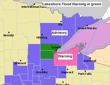
-Winter Storm Warning in effect from 7 PM this evening to 11 AM Sunday (pink area on map) including the cities of Superior, Solon Springs, Port Wing, Washburn, Cable and Bayfield.
-Winter Weather Advisory in effect from 7 PM this evening to 11 AM Sunday (purple area on map) including the cities of Grand Marais, Silver Bay, Isabella, Two Harbors, Duluth, Cloquet, Moose Lake, Sandstone, Grantsburg, Minong, Ashland and Gile.
-Lakeshore Flood Warning in effect from 7 PM this evening to 7 AM Sunday (dark green area on map) with lakeshore flooding and erosion possible from the Twin Ports areas of Canal Park, Park Point, Minnesota Point and Wisconsin Point eastward to across the Bayfield Peninsula to Saxon Harbor.
-Lakeshore Flood Advisory in effect from 7 PM this evening to 7 AM Sunday with lakeshore flooding along the North Shore from Two Harbors to Little Marais, and a Lakeshore Flood Advisory is in effect from 7 PM this evening to Noon Sunday for the South Shore with lakeshore flooding from Port Wing, east to Saxon Harbor.
Source: https://www.weather.gov/dlh/

With the potential for heavy wet snow coupled with strong winds later tonight into Sunday morning there is some potential for a few power outages in parts of northeast Minnesota and northwest Wisconsin.
Here are some links to power outage maps
Minnesota Power https://www.mnpower.com/OutageCenter/OutageMap
Lake Country Power http://outage.lcp.coop/#viewer-menu-parent
Links to road conditions
Minnesota https://lb.511mn.org/
Wisconsin https://511wi.gov/
MRMS radar loop ending at 4:30 PM CDT, Saturday, March 28, 2020.
Heavy precipitation (mainly rain) along with a few thunderstorms lifting slowly north out of southern Minnesota late this afternoon.
Source: https://lab.weathermodels.com/

Simulated radar forecast valid from 6 PM this evening through late Sunday night (Midnight)
Snow in blue, rain in green.
Note: Another thing we may see happen is for elevation to play role, meaning higher elevated areas (away from Lake Superior) see more snow compared to lower elevation areas (closer to Lake Superior) This hi-res model shows this type of scenario playing out later tonight through Sunday morning.
Source: 18z NAM-WRF model; https://weathermodels.com/
Precipitation will continue to slowly lift north/northeast into parts of the Northland this evening with the heaviest precipitation expected from late this evening through mid-morning Sunday, precipitation diminishes from NW-SE Sunday afternoon, but lake effect snow and rain could continue through Sunday evening along the South Shore of Lake Superior.

Not too surprised given the setup that is in place that we have a PDS tornado watch in effect until 9 PM tonight. Stay weather aware in the affected areas.
Source: https://www.spc.noaa.gov/

An impressive mid latitude cyclone lifting slowly northeast out of eastern Nebraska this afternoon per Goes-16 satellite imagery.
Source: https://weather.cod.edu/

And a look at today’s storm on Goes-16 mid level water vapor imagery.

One of the reasons for this evening’s potential outbreak of severe thunderstorms in parts of the mid-Mississippi Valley region are these very strong winds aloft which are spreading NE into a strongly sheared, warm, humid and unstable airmass.
Source: https://www.spc.noaa.gov/


…Outlook for Duluth and Superior…
*Winter Storm Warning for Superior from 7 PM this evening to 11 AM Sunday*
*Winter Weather Advisory for Duluth from 7 PM this evening to 11 AM Sunday*
*Lakeshore Flood Warning in effect from 7 PM this evening to 7 AM Sunday*
.Tonight… Windy. Patchy drizzle early. Rain and snow developing between 8-11 PM. Snow could be heavy at times overnight. Sleet also possible late. Low 33 to 35. Wind east to northeast 15 to 30 mph with gusts to 45 mph.
.Sunday… Blustery. Rain and snow in the morning. Snow could be heavy at times. Lingering rain showers and drizzle during the afternoon. Total snowfall accumulations of 3 to 7 inches. High 38 to 43. Wind north 15 to 25 mph with higher gusts.
Thanks for reading!
Tim
Leave a Reply