-It was an active morning across southern portions of the Northland as scattered strong to severe thunderstorms moved across those areas producing hail, frequent lightning and heavy rain.
-Thunderstorms started around the Brainerd area ~4 AM today, but the weather has calmed down quite a bit late this morning as the last of the storms push southeast across north-central Wisconsin and out of our local area.
Here are some radar shots from this morning’s storms.
4:18 AM – Severe Thunderstorm Warning issued for the Brainerd Lakes area (yellow outlined area on map) Note: This is the first severe thunderstorm warning issued this year in the Northland.

6:08 AM – Strong storms affecting the Brainerd area.

6:40 AM – Severe Thunderstorm Warning issued by the NWS (yellow outlined area) as severe thunderstorms pass south of the Aitkin area.

7:35 AM – Strong storms moved through the Sandstone and Hinckley areas

8:30 AM – Severe Thunderstorm Warning issued by the NWS for the Spooner and Shell Lake areas (yellow outlined area)

9:31 AM – An elevated supercell thunderstorm develops northeast of Ladysmith with radar indicating hail to 3 inches in diameter or larger than baseballs (Tea Cup size)
Note: Reports that have come into the NWS through 10 AM had hail up to Golf Ball size from this elevated supercell.

| Storm Reports from around the Northland from Tuesday, April 7, 2020 Source: https://www.weather.gov/dlh/ 9:10 AM: HAIL 0.25″ – Birchwood, WI (Washburn County) Lots of pea sized hail covering the ground. 8:50 AM: HAIL 0.25″ – 5 NNE Sarona, WI (Washburn County) 8:49 AM: HAIL 0.50″ – 3 S Spooner, WI (Washburn County) Mostly pea-sized hail, but the largest stones were measured around a half inch. 8:37 AM: HAIL 0.25″ – 2 ESE Spooner, WI (Washburn County) Very heavy pea-sized hail. Ground was whitened in 30 seconds. 8:35 AM: HAIL 0.88″ – Spooner, WI (Washburn County) 7:25 AM: HAIL 0.25″ – 4 W Hinckley, MN (Pine County) 6:49 AM: HAIL 0.70″ – 2 N Wealthwood, MN (Aitkin County) Lots of dime sized hail accumulated a quarter inch. 6:48 AM: HAIL 0.70″ – 1 SSW Deerwood, MN (Crow Wing County) Pea to dime-sized hail. 6:12 AM: HAIL 0.70″ – Brainerd, MN (Crow Wing County) Pea to dime sized hail. 6:01 AM: HAIL 1.25″ – Baxter, MN (Crow Wing County) Quarter to half dollar sized hail. 4:55 AM: HAIL 0.25″ – 1 SE Barrows, MN (Crow Wing County) Pea-sized hail fell between 4:50 and 4:55 AM. 4:10 AM: HAIL 0.50″ – 1 N Fort Ripley, MN (Crow Wing County) |
Storms earlier this morning were big time lightning producers especially from central Minnesota into north-central Wisconsin thanks in part to impressive lapse rates and a decent amount of elevated instability (CAPE) over portions of the upper Midwest.
Note: All of the different colors on the map below represent where lightning has occurred over the last 12 hours (ending at 11 AM Tuesday)
Source: https://www.lightningmaps.org/

Goes-16 visible satellite imagery from this morning showing the scattered strong to severe thunderstorms which impacted parts of east-central Minnesota between 4-7 AM, and now moving through parts of northwest and north-central Wisconsin as of mid morning Tuesday.
Source: https://weather.cod.edu/

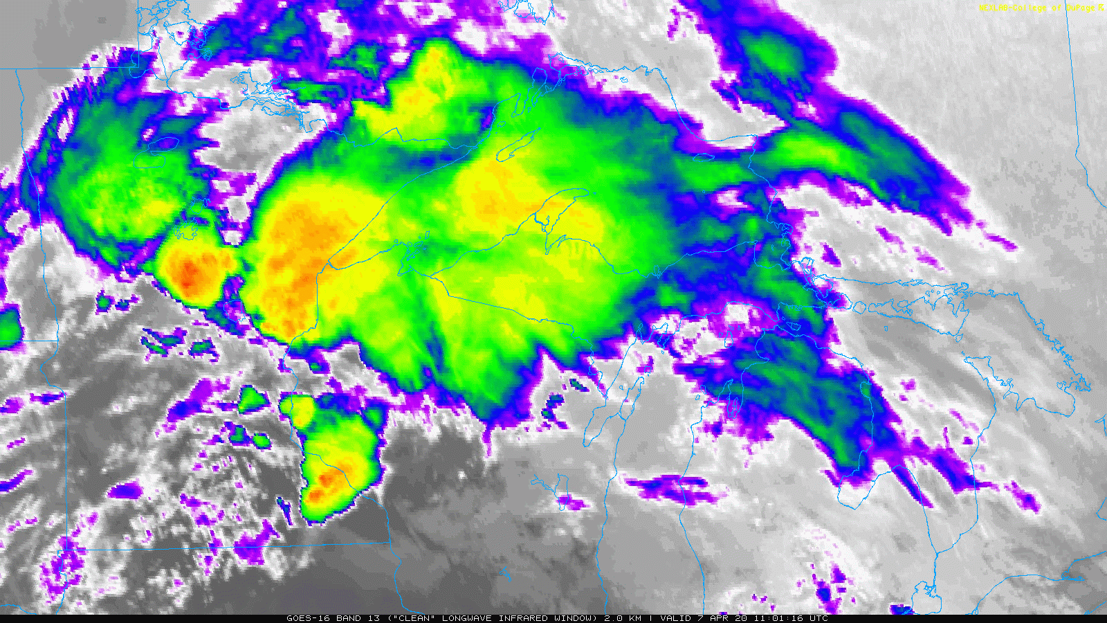
Goes-16 infrared satellite loop from this morning with the orange and red colors on the map indicating colder cloud tops (convection)

Thanks for reading!
Tim
Leave a Reply