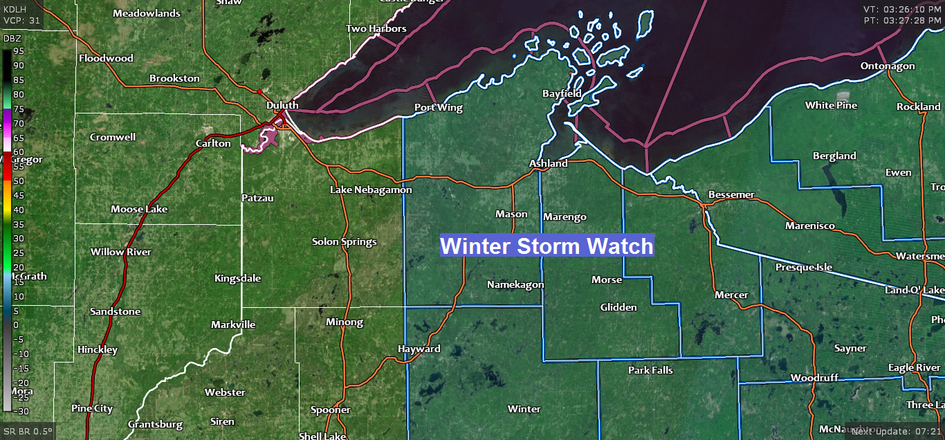
-Winter Storm Watch has been issued for parts of northwest Wisconsin from Sunday evening through Monday evening (blue shaded area on map)
-Some cities included in the watch are Port Wing, Bayfield, Washburn, Ashland, Glidden, Hurley, Gile, Hayward and Winter.
-Potential for significant snowfall amounts in the watch area. Gusty winds could cause areas of blowing snow Sunday night and Monday.
-Travel could be very difficult from Sunday evening through Monday.

There continues to be some uncertainty on the storm track and how much phasing occurs between a low to our SE and a trough which digs into the upper Midwest this weekend.
Snowfall amounts shown on the map could increase/decrease, and the snowfall gradients could shift farther west or east in the next 24 hours. Stay tuned.
Potential for 4-8″+ snowfall amounts appear to be greatest in far SE sections of the Northland including the Hurley and Gile areas.
Snowfall of 1 to 4 inches are possible in northeast Minnesota and far eastern Minnesota into most of northwest Wisconsin including Grand Marais, Ely, Silver Bay, Two Harbors, Duluth, Superior, Ashland, Grantsburg, Shell Lake and Hayward.

Notice how the solid black lines on the map which start in a SW-NE direction Sunday morning bend more to a S-N direction by Sunday night and Monday, this indicates that the approaching trough from the NW undergoes a slight shift to negative tilt at least according to the NAM model. How much this trough can bend back will be key in determining how much snow we get in parts of the Northland late this weekend. If the trough ends up flatter (less negative tilt) the chances for accumulating snow diminishes while shifting farther east.
Source: 18z NAM model 4.10.2020; https://www.tropicaltidbits.com/

The threat for severe thunderstorms continues across the southern US through the weekend with Easter Sunday featuring a potential severe weather outbreak including a risk for strong, long tracked tornadoes!
The Storm Prediction Center already has a moderate risk of severe thunderstorms out for Sunday for portions of Louisiana, Arkansas, Mississippi and Alabama (red shaded area on map) An enhanced and slight risk of severe thunderstorms surrounds the moderate risk area.

Here’s the significant tornado parameter forecast valid from 7 AM Sunday to 1 AM Monday per 18z NAM model from Friday, April 10, 2020.
The red, pink, purple and blue colors indicate values of 4 to 10 which are extremely high when looking at the significant tornado parameter. Typically values >1 indicate the potential for tornadoes (possibly significant) if other ingredients are in place, so yes Sunday could be a big day for severe weather.
Source: https://weather.cod.edu/

A strong upper low continues to move slowly east across southern California today. This system will move out into the Plains this weekend.
Source: Goes-16 sandwich imagery 4.10.2020; https://weather.cod.edu/

Goes-16 water vapor imagery from Friday shows one powerful storm exiting the northeast US while the next storm moves east out of California. Also note the energy which is diving SE out of western Canada, and the strong subtropical jet stream which extends from the Baja region through the southern US.

It’s been a very active week for severe weather in the US.
*Over 900 filtered reports of severe weather from April 6 to April 9, 2020. 605 damaging wind reports, 305 large hail reports and 15 tornado reports.
The maps below show filtered severe weather reports for the dates listed on the maps.
Green dots=Hail reports
Blue dots=Wind reports
Red dots=Tornado reports
Source: https://www.spc.noaa.gov/


…Weather Summary…
Quiet weather will continue in our area tonight and Saturday.
Partly to mostly cloudy skies will be found across the Northland through Saturday. Lows tonight will range from the lower 20s to lower 30s with winds shifting to south/southwest.
On Saturday will see a cold front move SE across the area. This front should come through dry, but a few light snow or rain showers can’t be ruled out in the morning in extreme northern Minnesota. Highs on Saturday will range from the lower 40s to middle 50s with the warmest temps found in northwest Wisconsin and eastern Minnesota. South or southwest winds become north to northwest once the cold front moves through.
Dry weather continues Saturday night and possibly into Sunday morning. After that parts of the area could be impacted by a strong spring storm with snow slowly spreading north into northwestern Wisconsin Sunday afternoon, and perhaps into eastern and northeast Minnesota by Sunday night.
There should be a lot of dry air up north on Sunday which could play a role on how far north the snow gets, also the amount of convection in the warm sector of this storm could keep this system on a more southerly track which could greatly reduce the amount of snow in our area. On the other hand, if this storm comes together like some of the models are showing, then a major winter storm could impact portions of northwest Wisconsin, and maybe even northeast Minnesota with wet heavy snow and gusty winds. Note: Some power outages and tree damage is possible Sunday night and Monday if snow accumulations become significant enough since this should be a wet snowfall.
Forecast for Duluth and Superior
.Tonight… Partly to mostly cloudy. Low 28 to 33. Wind west 10 to 15 mph becoming south.
.Saturday… Partly to mostly cloudy. High 49 to 54. Wind southwest 10 to 15 mph becoming north in the afternoon.
.Easter Sunday… Partly to mostly cloudy. High 35 to 40. Wind north 10 to 20 mph.
| Normal temperatures for April 11 High 47 Low 28 Sunrise Saturday 6:28 AM CDT Sunset Saturday 7:52 PM CDT |
Thanks for reading!
Tim
Leave a Reply