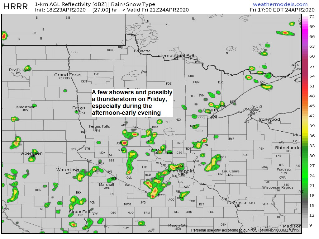
-A few showers are possible in northeast Minnesota and northwest Wisconsin on Friday, but coverage of the showers should be fairly isolated, with several dry hours likely, and even some sun at times on Friday.
-Computer models are generating some weak CAPE Friday afternoon while a pocket of steeper lapse rates (~7.0 C/km) moves over the area, this could be enough to trigger an isolated thunderstorm Friday afternoon.
-Temperatures Friday afternoon are forecast to be in the middle 50s to lower 60s, but it will be a little cooler near Lake Superior, but a lighter lake wind sets up on Friday so temperatures should trend a bit warmer compared to the last few days by the lake.
It’s a messy pattern right now, and it will remain that way through the weekend.
Basically we’re in a NW flow right now with a couple disturbances embedded in the flow dropping ESE out of the Northern Rockies and Northern Plains, these features combined with some colder air aloft (500mb temps in the -20s C) will go on to produce some showers in parts of the Northland over the next few days, but Friday holds the best chance for some rain at times (shower coverage peaking during the afternoon/early evening)
Source: Goes-16 water vapor imagery 4.23.2020; https://weather.cod.edu/

Simulated radar forecast valid from 7 PM Thursday to 7 PM Saturday.
Source: 18z NAM-WRF model 4.23.2020; https://weathermodels.com/

Early next week (~April 28) could turn a bit wet in northeast Minnesota and northwest Wisconsin as a more organized low pressure system develops while possibly bringing widespread rainfall to the Northland, but this will depend on the track this system takes.
Source: https://www.wpc.ncep.noaa.gov/

More severe weather along with a risk for some tornadoes through tonight across the southeast US as a potent trough approaches from the west which enhances broad scale lift over an environment consisting of warm, humid, unstable air with strong winds aloft.
Source: 12z HREF model 4.23.2020; https://www.spc.noaa.gov/

Goes-16 water vapor loop from today, Thursday, April 23, 2020 showing a strong system impacting areas from the Ohio Valley to the southeast US, this is the same storm which produced severe weather a little further west on Wednesday.
Source: https://weather.cod.edu/

It was a rough afternoon and evening across portions of the Southern Plains on Wednesday with numerous severe thunderstorms and tornadoes.
One area which had severe weather was in south-central Oklahoma thanks to a dryline which moved east to near the I35 corridor during the afternoon. South-southeast winds ahead of this boundary helped draw plenty of warm, humid and unstable air northward while much drier/more stable air was found behind the dryline.
Scattered supercells developed late Wednesday afternoon out ahead of the dryline in Oklahoma.

Shown on the image below are dew point temperatures from 4 PM Wednesday.
Source: https://www.spc.noaa.gov/

The other area where severe thunderstorms and tornadoes occurred on Wednesday was over northeastern Texas into west-central Louisiana where strong divergence was in place due to a 100+ knot upper level jet which was cutting across central Texas.

Here are some radar images from Wednesday evening of a tornadic supercell which produced a long track tornado, starting around Seven Oaks, Texas, this tornado would then track through the Jasper, TX area before crossing over into west-central Louisiana from mid to late Wednesday evening – Two tornado emergencies were issued from this storm.
This storm had very strong tornado signatures on radar imagery.


Synoptic setup for Wednesday’s severe weather event (April 22, 2020)
Source: https://weather.cod.edu/

And here’s an animation of the image above (Goes-16 water vapor loop)

27 filtered tornado reports on Wednesday (red dots on map below) Tornadoes were reported in Oklahoma, Texas, Louisiana and Mississippi.
Source: https://www.spc.noaa.gov/

Forecast for Duluth and Superior
.Tonight… Partly to mostly cloudy. Low 27 to 32. Wind east to northeast 10 to 20 mph.
.Friday… Partly sunny. A few showers possible later in the afternoon. High 53 to 58 but a little cooler near Lake Superior. Wind variable 6 to 13 mph.
.Saturday… Breezy. Partly to mostly cloudy. High 43 to 48 but cooler near Lake Superior. Wind east 15 to 25 mph.
| Normal temperatures for April 24 High 54 Low 34 Sunrise Friday 6:04 AM CDT Sunset Friday 8:10 PM CDT |
Thanks for reading!
Tim
Leave a Reply