-It’s a good thing we got some rain in Duluth Monday morning because it’s not a guarantee will be getting more rain on Tuesday, and after Tuesday it looks like will be going right back into a dry pattern for a little while.
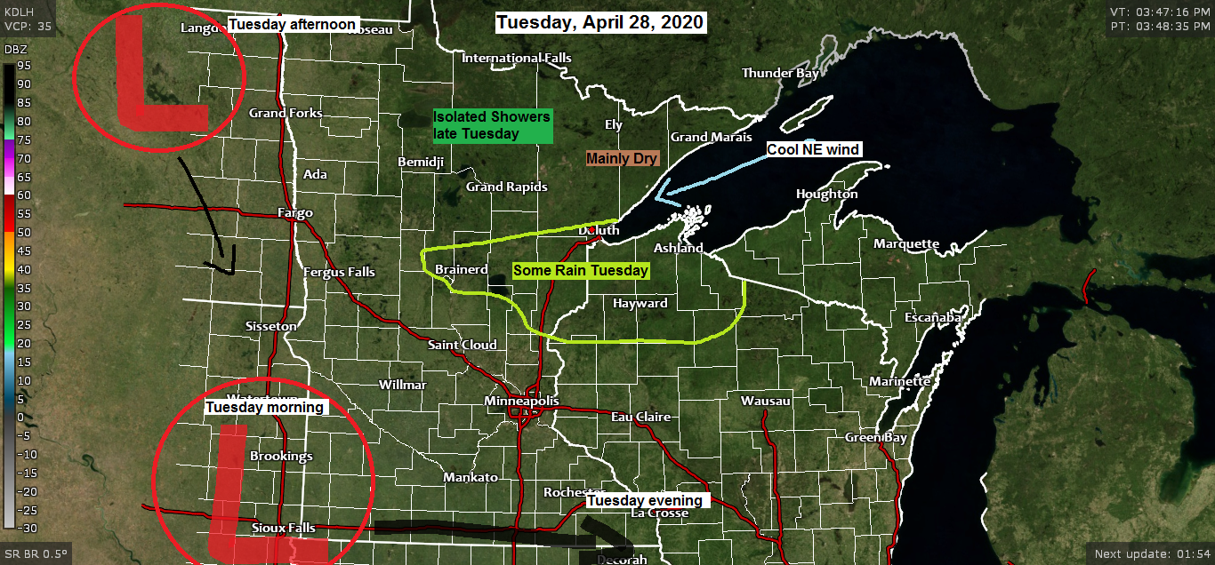
-Speaking of Tuesday’s system, I’ve been watching this one for days, and what started out like it would be a good soaking for much of the Northland has changed quite a bit over the last day or so. It now looks like the heaviest rainfall will remain south of our area on Tuesday, but some rain (mostly light stuff) is still possible across east-central Minnesota and northwest Wisconsin including for the Twin Ports of Duluth and Superior.
-It should be noted that there continues to be big model disagreement with Tuesday’s system with the afternoon HRRR (18z run) keeping most of the area dry on Tuesday, while the latest NAM (18z run) shifted things back north again with a swath of heavier QPF (rainfall) from about the Twin Ports on south. German-Icon, Australian and Canadian models keep the rain mostly south of the Northland on Tuesday, while the GFS and Euro models show at least a little rain impacting southern areas and Duluth on Tuesday. I guess you could call this a little MODEL CHAOS for Tuesday, those are always fun!
Here’s a look at two completely different outcomes for Tuesday’s weather.
18z NAM-WRF model simulated radar forecast from 7 AM Tuesday to 7 AM Wednesday – Rain impacts areas roughly south of a line from about Brainerd to Silver Bay on Tuesday, spreading from SW to NE during the day.
Source: https://weathermodels.com/

And here’s the 18z HRRR model simulated radar forecast from 7 AM Tuesday to 1 AM Wednesday – One batch of rain passes south of us, then we see scattered showers develop across north-central Minnesota later Tuesday afternoon into Tuesday evening.

When you blend the computer models together, here’s what they come up with for potential rain totals for Tuesday through early Wednesday.
Source: https://lab.weathermodels.com/

Rainfall Reports from around the Northland for Sunday night-Monday morning, April 26-27, 2020.
Source: https://mesowest.utah.edu/
| Duluth Airport: 0.48″ Saginaw, MN: 0.44″ Orr, MN: 0.41″ Siren, WI: 0.39″ Bigfork, MN: 0.37″ Barnes, WI: 0.37″ Hayward, WI: 0.35″ Ely, MN: 0.34″ McGregor, MN: 0.33″ Moose Lake, MN: 0.32″ Silver Bay, MN: 0.31″ Isabella, MN: 0.30″ Eveleth-Virginia, MN: 0.30″ Grand Marais, MN: 0.27″ Superior Airport: 0.27″ Kabetogama, MN: 0.26″ Chisholm-Hibbing Airport: 0.26″ Minong, WI: 0.24″ Clam Lake, WI: 0.23″ Glidden, WI: 0.23″ Hinckley, MN: 0.22″ International Falls, MN: 0.21″ Ashland, WI: 0.21″ Washburn, WI: 0.20″ Solon Springs, WI: 0.20″ Littlefork, MN: 0.20″ Walker, MN: 0.20″ Pine River, MN: 0.17″ Brainerd, MN: 0.17″ Grand Rapids, MN: 0.15″ Cass Lake, MN: 0.14″ |
System which brought rain to the Northland earlier today is getting sheared apart this afternoon as most of the energy heads NE into Hudson Bay.
Off to our west is the next system, but this one will drop southeast once it reaches the Northern Plains.
Water vapor loop from today, Monday, April 27, 2020.
Source: https://weather.cod.edu/

Forecast for Duluth and Superior
.Tonight… Breezy. Partly to mostly cloudy. Patchy fog and drizzle possible near Lake Superior. Low 34 to 38. Wind east to northeast 10 to 20 mph.
.Tuesday… Breezy. Mostly cloudy with some rain possible especially from late morning through the afternoon. Patchy fog and drizzle. High 40 to 45. Wind northeast 10 to 20 mph with stronger gusts possible.
.Wednesday… Breezy. Partly to mostly cloudy. High 52 to 57 but cooler near Lake Superior. Wind north to northeast 10 to 20 mph.
| Normal temperatures for April 28 High 56 Low 35 Sunrise Tuesday 5:58 AM CDT Sunset Tuesday 8:16 PM CDT |
Thanks for reading!
Tim
Leave a Reply