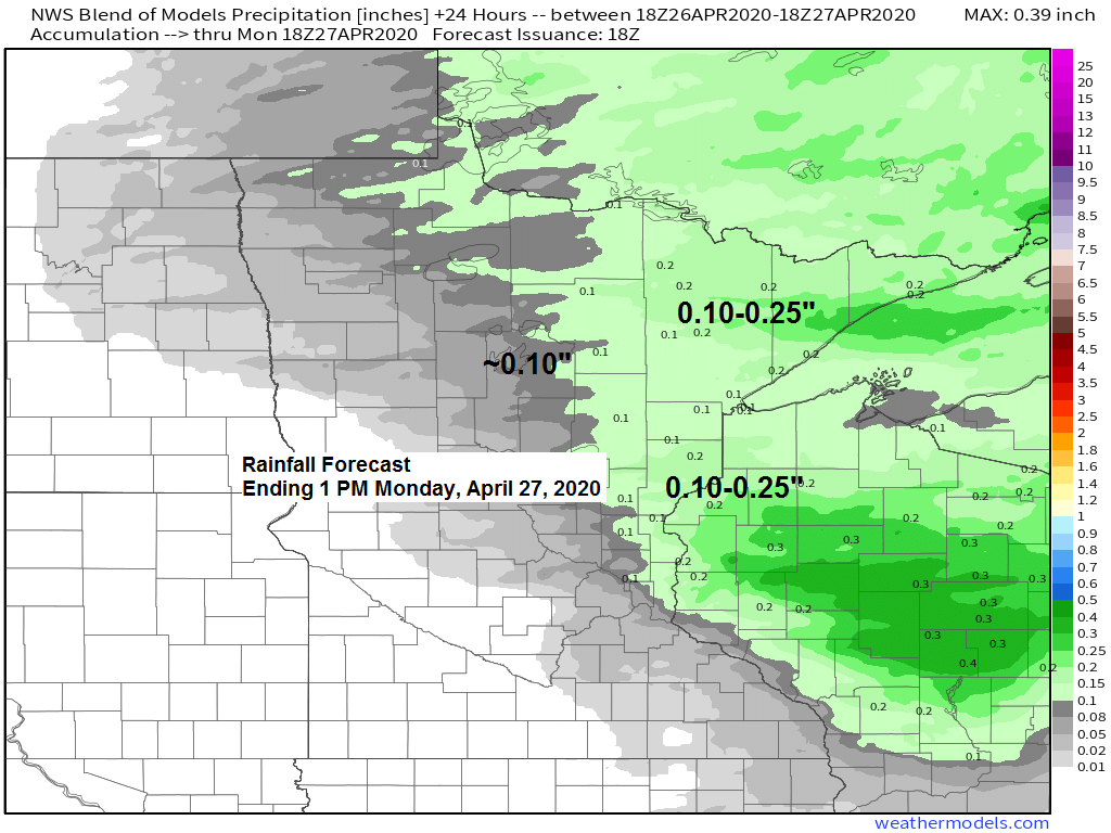
-Some rain will move across northeast Minnesota and northwest Wisconsin later tonight/early Monday morning, but this rain will exit quickly off to the east by mid-morning Monday. Rainfall totals for this event look to be in that 0.10 to 0.25″ range in most of the area, but the pattern has been a dry one lately, especially near Lake Superior, so it wouldn’t surprise me if rain totals end up a little lower near Lake Superior.
-Monday afternoon looks mainly dry in the Northland with mild temperatures as highs climb into the middle 60s to lower 70s, but it will remain cooler closer to Lake Superior as light east winds continue, but there is a chance that west winds become strong enough for roughly 6 hours Monday afternoon-early Monday evening causing temperatures to warm into the 60s even for locations below the hill in Duluth, but that chance is quite low, it is late April after all.
Here’s a look at the simulated radar forecast valid from 7 this evening to 7 PM Monday.
Source: 18z NAM-WRF model 4.26.2020; https://weathermodels.com/

A look at our approaching system for late tonight on Goes-16 imagery.
Visible image below, and the water vapor image below that.
Its a strong system right now, and it should maintain its strength as it moves over the Northland late tonight, so we should be able to get some rain, problem is this system is moving through quickly which will limit the amount of rain we get.
Source: https://weather.cod.edu/

Water vapor imagery

The last 3 weeks have been quite dry in most of the Northland, check out how much precipitation we’ve seen and the departure from normal for the period April 5 through April 25, 2020.
Brainerd: 0.76″ (-0.84″ below normal)
Duluth: 0.25″ (-1.44″ below normal)
International Falls: 0.08″ (-0.95″ below normal)
Two Harbors: 0.06″ (-1.73″ below normal)
-International Falls has had only 2-5% of its normal precipitation so far this month while in Duluth precip totals so far this month are running 10-25% of normal.
-Precipitation totals so far this month have been a little higher in other parts of the Northland, but are still running below average. Grand Marais, Brainerd, Hinckley and Ashland have had 25-50% of its normal precipitation so far this month, while Hayward has had 50-75% of its normal precipitation.
Source: https://mrcc.illinois.edu/

Looking at another chance for rain on Tuesday, but there continues to be uncertainty with the track of this next low and how much rain it brings to the Northland. Stay tuned.

Temperatures are forecast to be warmer than average this week across the Northland, but as is usually the case in spring, temperatures near Lake Superior will be highly dependent on wind direction. It looks like will have several days this week with east winds meaning it will be much cooler by Lake Superior, but maybe, just maybe will squeeze out 2 days this week with offshore winds (warmer temps) near the lake, will see.
Note: Normal highs in the Northland on April 27th range from the mid to upper 50s with normal lows in the low to mid 30s. Normal highs on May 2nd range from the upper 50s to around 60 degrees with normal lows ranging from the mid to upper 30s.
Source: 12z European ensemble model 4.26.2020; https://weathermodels.com/

A cooler weather pattern is possible for the 1st full week of May.
Source: 12z European ensemble model 4.26.2020

Temperature and Precipitation report for Duluth, Minnesota for April 19 to April 25, 2020
| High Temperatures/Departure from Normal 4.19: 44 F/-7 degrees below normal 4.20: 48 F/-4 degrees below normal 4.21: 41 F/-11 degrees below normal 4.22: 42 F/-11 degrees below normal 4.23: 46 F/-7 degrees below normal 4.24: 64 F/+10 degrees above normal 4.25: 55 F/+1 degree above normal Low Temperatures/Departure from Normal 4.19: 27 F/-5 degrees below normal 4.20: 27 F/-5 degrees below normal 4.21: 21 F/-11 degrees below normal 4.22: 29 F/-4 degrees below normal 4.23: 29 F/-4 degrees below normal 4.24: 29 F/-5 degrees below normal 4.25: 31 F/-3 degrees below normal Note: Average temperature in Duluth for the week of April 19, 2020: 38.1 degrees; -4.7 degrees below normal. Source: https://www.dnr.state.mn.us/ Total precipitation: 0.01″ Normal: 0.61″ Departure: -0.60″ below normal State Average for Minnesota for the week of April 19, 2020 Temperature: 44.1 degrees Departure: -2.8 degrees below normal Precipitation: 0.05″ Departure: -0.60″ below normal |
Average temperature, departure from mean for the week of April 19, 2020. Source: https://mrcc.illinois.edu/

Total precipitation, departure from mean for the week of April 19, 2020.

Forecast for Duluth and Superior
.Tonight… Breezy. Increasing cloudiness. Some rain mainly after 3 AM. Low 34 to 38. Wind east 15 to 25 mph.
.Monday… Rain ending before 8 AM. Mostly cloudy with afternoon clearing. Mild. High 64 to 69 but cooler near Lake Superior. Wind east 5 to 15 mph becoming west 10 to 20 mph.
.Tuesday… Breezy and cooler. Mostly cloudy. Some light rain possible late. High 40 to 45. Wind northeast 10 to 20 mph.
| Normal temperatures for April 27 High 55 Low 35 Sunrise Monday 5:59 AM CDT Sunset Monday 8:14 PM CDT |
Thanks for reading!
Tim
Leave a Reply