Dry weather continues across the Northland for the next few days.
Warmest temperatures will be found inland from Lake Superior by some 10 to 20 miles. Daytime highs for inland locations will be in the 60s and 70s Tuesday, Wednesday and Thursday with easterly winds 5 to 15 mph with higher gusts during the afternoon and evening. Winds become more south-southeast Wednesday and Thursday.
Locations near Lake Superior will have highs somewhere in the 47 to 55 degree range Tuesday, Wednesday and Thursday with east winds 10 to 20 mph, but stronger wind gusts are likely this evening and again on Tuesday.
Much of northern and northeastern Minnesota are in extreme (red) to very high (orange) fire danger through this evening.
Source: https://www.dnr.state.mn.us/

A Red Flag Warning continues until 7 PM this evening for parts of northeast and north-central Minnesota (pink shaded area on map)
-East winds 15 to 20 mph with gusts to 40 mph.
-Relative humidity as low as 22 percent.
A reg flag warning means that critical fire weather conditions are either occurring now, or will shortly. A combination of strong winds, low relative humidity, and warm temperatures can contribute to extreme fire behavior.
Note: Lots of fire icons showing up today over eastern North Dakota and western Minnesota.

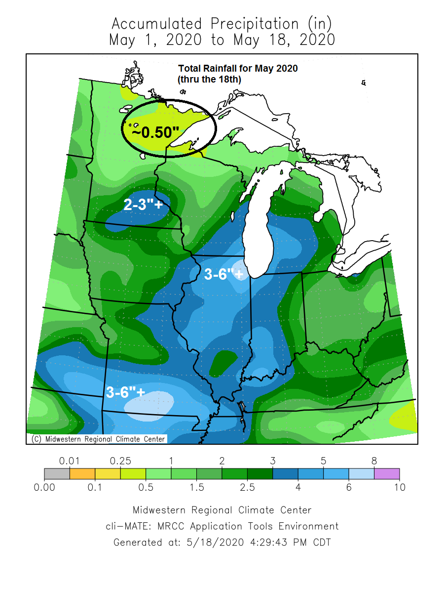
It’s been a dry May across the Northland with precipitation totals so far for the month running just 10-25% of normal.
Source: https://mrcc.illinois.edu/

Long range model guidance continues to show a dry bias lingering for the rest of this month across northeast Minnesota and northwest Wisconsin, but will likely get some rain at times, but not enough to tilt us above normal.
Source: 12z European ensemble model 5.18.2020

A Tropical Storm (Arthur) and 2 strong low pressure systems lined up from east to west today.

Here’s how all 3 systems look on a visible satellite loop from Monday, May 18, 2020.
Source: https://weather.cod.edu/

A very amplified/blocked up weather pattern right now, and there won’t be a whole lot of change to this pattern for the next few days.
Upper lows/troughs to the east and west of a strong upper level ridge which was over the Plains today.

Forecast for Duluth and Superior
.Tonight… Windy this evening. Mainly clear. Low 41 to 46. Wind east 15 to 30 mph with gusts to 40 mph. Wind decreasing to 10 to 20 mph late.
.Tuesday… Breezy. Partly to mostly sunny. High 57 to 62 but cooler near Lake Superior. Wind east 15 to 30 mph.
.Wednesday… Partly cloudy. High 64 to 69 but cooler near Lake Superior. Wind east 10 to 20 mph.
| Normal temperatures for May 19 High 63 Low 42 Records for May 19 High: 85 degrees set in 1972 Low: 26 degrees set in 1929 Sunrise Tuesday 5:29 AM CDT Sunset Tuesday 8:42 PM CDT |
Thanks for reading!
Tim
Leave a Reply