Howling winds will continue near Lake Superior the next few days with a stiff northeast wind 15 to 30 mph (gusting to around 40 mph) the wind will kick up some dust at times. Temperatures near Lake Superior won’t vary much through Wednesday with daytime highs of 45 to 55 degrees, and overnight lows around 40 degrees. Note: A cool lake breeze looks to continue past Wednesday, but not quite as windy as it will be the next few days, but still not real pleasant.
If you’re inland by 10 to 20 miles of Lake Superior your weather will be much nicer this week. High temps in the 60s and 70s Monday, Tuesday and Wednesday with a lot less wind.
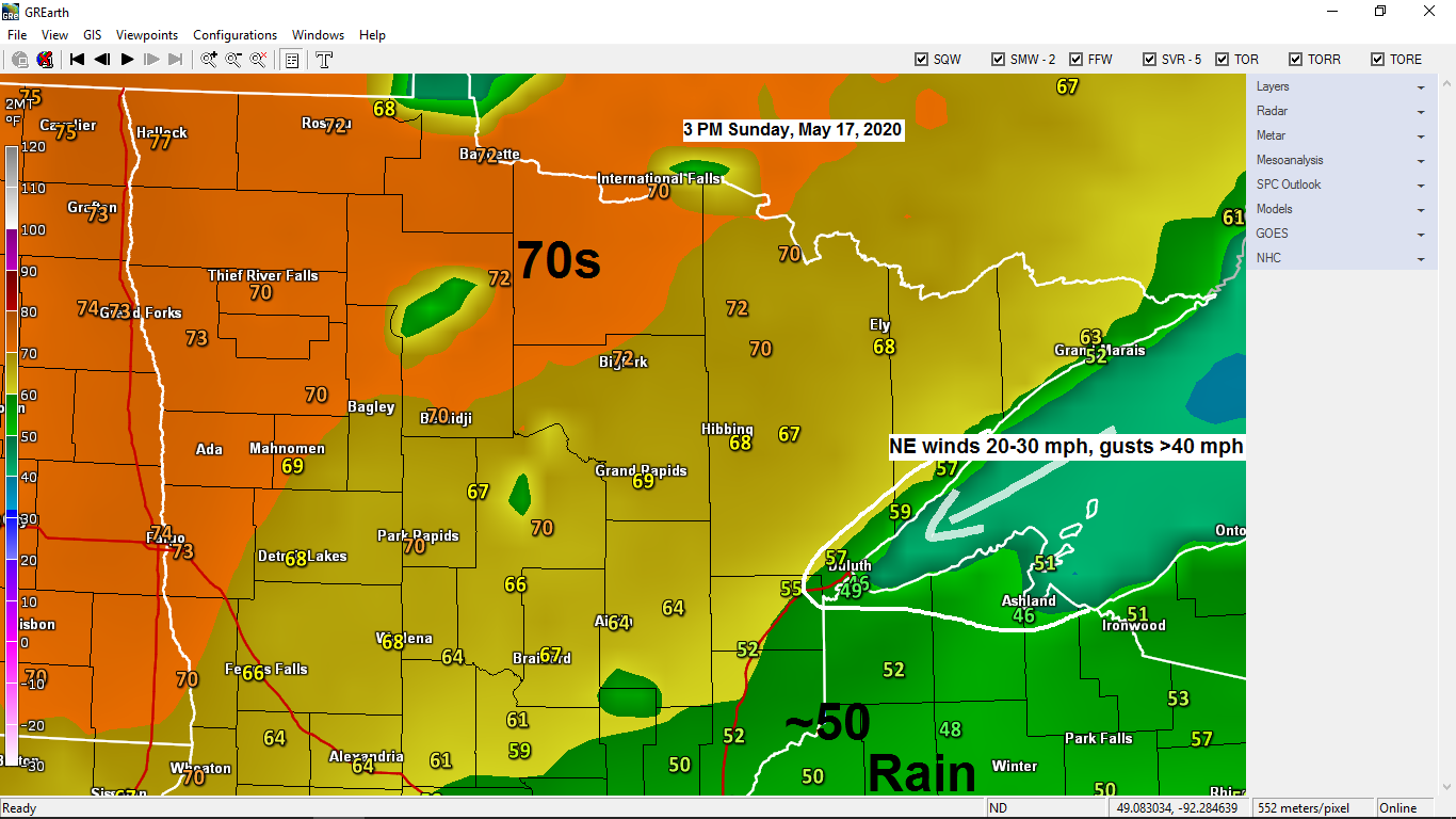
Rain in far eastern Minnesota and southern portions of northwest Wisconsin is expected to end from NW-SE later this evening, and then it looks mainly dry across the Northland through Thursday.

Impressive rainfall totals over the past 12 hours south of the Twin Ports!

| 24-Hour Rainfall Reports from around the Northland Note: Totals below are from 3 PM Saturday to 3 PM Sunday, May 16-17, 2020 Source: https://mesowest.utah.edu/ Siren, WI: 0.87″ Clam Lake, WI: 0.46″ Hayward, WI: 0.42″ Minong, WI: 0.38″ Solon Springs, WI: 0.26″ Glidden, WI: 0.19″ Hinckley, MN: 0.15″ Ashland, WI: 0.09″ Washburn, WI: 0.05″ |
Quite a storm affecting parts of the upper Midwest today, here’s how this system looks on Goes-16 water vapor imagery Sunday afternoon, May 17, 2020.
Source: https://weather.cod.edu/

Abundant moisture continues to lift north out of the Gulf of Mexico today while lift associated with the strong low over Iowa results in a widespread area of rain (some heavy) from the Southern Plains to the upper Midwest today, but dry air pushing SW off the strong Hudson Bay high is keeping northern Minnesota and areas near Lake Superior dry today.

Forecast track of Tropical Storm Arthur per National Hurricane Center.
This will be a slow moving system, but it is forecast to remain offshore as it moves north-northeast, and eventually to the east-southeast later this week.
T=Tropical Storm icon and the solid white line is the forecast track of Arthur.

Temperatures are forecast to be above normal in northeast Minnesota and northwest Wisconsin this week, but near Lake Superior it will be quite a bit cooler!
Note: Normal highs in the Northland this week are generally in the middle 60s while normal lows are in in the lower 40s.
Source: 12z European ensemble model 5.17.2020

Temperature and Precipitation report for Duluth, Minnesota for May 10 to May 16, 2020.
| High Temperatures/Departure from Normal 5/10: 46 F/-15 degrees below normal 5/11: 50 F/-11 degrees below normal 5/12: 56 F/-5 degrees below normal 5/13: 51 F/-11 degrees below normal 5/14: 65 F/+3 degrees above normal 5/15: 62 F/Normal 5/16: 58 F/-4 degrees below normal Low Temperatures/Departure from Normal 5/10: 34 F/-5 degrees below normal 5/11: 29 F/-10 degrees below normal 5/12: 28 F/-12 degrees below normal 5/13: 32 F/-8 degrees below normal 5/14: 41 F/+1 degree above normal 5/15: 44 F/+4 degrees above normal 5/16: 41 F/Normal Note: Average temperature in Duluth for the week of May 10th, 2020: 45.5 degrees; -5.2 degrees below normal. Source: https://www.dnr.state.mn.us/ Total Precipitation: 0.28″ Normal: 0.71″ Departure: -0.43″ below normal State Average for Minnesota for the week of May 10th, 2020 Temperature: 46.9 degrees Departure: -8.1 degrees below normal Precipitation: 0.31″ Departure: -0.42″ below normal |
Last week was another cool one across the Northland with average temps anywhere from 5 to 10 degrees below normal.
Source: https://mrcc.illinois.edu/

Last week was dry too, but that’s been the norm for weeks now. Note: Most of the Northland saw just 10-25% of its normal precipitation last week.

Forecast for Duluth and Superior
.Tonight… Windy. Partly to mostly cloudy. Low 40 to 45. Wind east to northeast 15 to 30 mph with higher gusts.
.Monday… Windy. Partly cloudy. High 58 to 63 but cooler near Lake Superior. Wind east to northeast 15 to 30 mph with higher gusts.
.Tuesday… Windy. Partly cloudy. High 56 to 61 but cooler near Lake Superior. Wind east to northeast 15 to 30 mph.
| Normal temperatures for May 18 High 63 Low 41 Records for May 18 High: 87 degrees set in 2012 Low: 27 degrees set in 1915 Sunrise Monday 5:30 AM CDT Sunset Monday 8:41 PM CDT |
Thanks for reading!
Tim
Leave a Reply