Back and fourth we go! Rain or no rain?
Model guidance is split on how far north the rain will get this weekend.
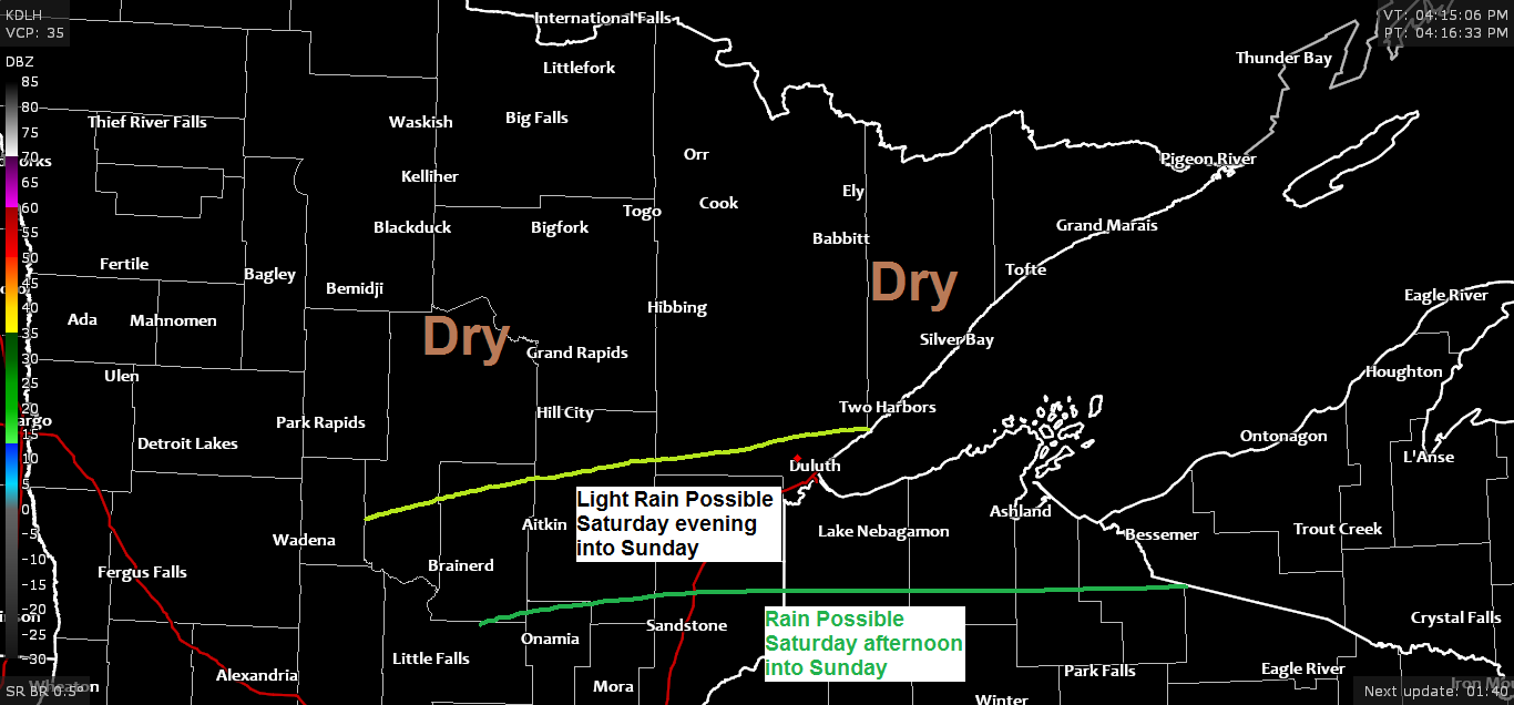
By far the NAM model is the most aggressive model today as it pushes the heavier rainfall well to the north with it impacting the Brainerd lakes, Twin Ports, North Shore into northwest Wisconsin well the Euro model keeps the heavier rain further south. Canadian model agrees with the Euro as does the German-Icon, UK and Australia Access-G models, while the GFS model agrees with the NAM.
As for timing – Some rain could begin Saturday afternoon over southern parts of the Northland (Brainerd lakes to Hayward lakes) but most of the rain along this corridor looks to fall Saturday night into Sunday, ending from west to east Sunday afternoon.
This weekend looks dry across northern Minnesota into the Arrowhead.
Highs Saturday and Sunday are forecast to be in the 60s to around 70 degrees in northern Minnesota, but it will be much cooler near Lake Superior with highs in the 40s and 50s. Highs across northwest Wisconsin are forecast to be in the 50s and 60s on Saturday, and in the 50s Sunday.
Note: My forecast for Duluth and Superior is leaning toward the further south/drier model solutions, although I do think we may see a little light rain at times in Duluth and Superior from Saturday evening into Sunday, but the heaviest rainfall of a half inch to over an inch should remain south of Duluth and Superior this weekend.

Potential is there for gusty northeast winds near Lake Superior this weekend, especially Saturday night into Sunday, that’s when we could have wind gusts up to around 30 mph.
Source: 18z NAM 3km model 5.15.2020

Still looking at a very amplified/blocking pattern for next week as an Omega Block develops.
Upper lows/troughs covering the western and eastern portions of the US while a large ridge covers the Plains.
Winds aloft will be strongest near the aforementioned troughs/lows, while weak winds aloft will be in place near the ridge. A separate corridor of stronger winds aloft will be found across much of Canada.
Note: The pattern for next week is a dry one for northeast Minnesota and northwest Wisconsin as will firmly be under the ridge.
The warmest days look to be ~May 20 to 22, this is when much of the Northland could have highs in the 70s, and maybe even a few 80s!
It looks much cooler near Lake Superior for most of next week as it looks like will keep an easterly wind going, but there is a chance for a warmer/southerly wind to take over late next week (Thursday-Friday)
Source: 12z GFS model 5.15.2020

Forecast for Duluth and Superior
.Tonight… Partly to mostly cloudy. Low 40 to 45. Wind east 5 to 15 mph.
.Saturday… Mostly cloudy. Light rain possible especially Saturday night. High 55 to 60 but cooler near Lake Superior. Wind east 10 to 20 mph.
.Sunday… Breezy and cool. Mostly cloudy. Light rain possible. High 45 to 50. Wind northeast 15 to 25 mph with higher gusts possible.
| Normal temperatures for May 16 High 62 Low 41 Records for May 16 High: 88 degrees set in 2018 Low: 20 degrees set in 1929 Sunrise Saturday 5:32 AM CDT Sunset Saturday 8:39 PM CDT |
Thanks for reading!
Tim
Leave a Reply