Rainfall Reports from around the Northland from Monday, June 1, 2020
Source: https://mesowest.utah.edu
Ely, MN: 0.43″
Isabella, MN: 0.33″
International Falls, MN: 0.22″
Silver Bay, MN: 0.21″
Hinckley, MN: 0.17″
Brainerd, MN: 0.15″
Solon Springs, WI: 0.14″
Minong, WI: 0.13″
Washburn, WI: 0.13″
Moose Lake, MN: 0.12″
Pine River, MN: 0.09″
Ashland, WI: 0.09″
Littlefork, MN: 0.08″
Clam Lake, WI: 0.08″
Superior Airport: 0.06″
Barnes, WI: 0.06″
Hayward, WI: 0.06″
Grand Marais Airport: 0.02″
Duluth Airport: 0.01″
Local Storm Reports from Monday, June 1, 2020
Source: https://www.weather.gov/dlh/
11:50 AM: Hail 0.50″. Hinckley, MN (Pine County)
10:27 AM: Hail 2.50″. 5 SW Pine Center, MN (Crow Wing County) Tennis Ball sized hail.
10:24 AM: Hail 1.00″. 1 N Pine Center, MN (Crow Wing County) Quarter sized hail.
10:18 AM: Hail 1.00″. 5 W Pine Center, MN (Crow Wing County) Quarter sized hail.
10:10 AM: Hail 0.88″. 7 W Pine Center, MN (Crow Wing County)
10:00 AM: Hail 0.88″. Pine Center, MN (Crow Wing County)
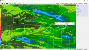
Here’s a look at how the thunderstorms looked Monday morning on Goes-16 Day Cloud Phase imagery.
Source: https://weather.cod.edu

Temperatures are approaching 100 degrees this Monday afternoon in far western Minnesota with Canby reporting 99 degrees at 4 PM today. Near 90 degree temps as far east as Brainerd this afternoon, and 80 degree temps from Bigfork to Moose Lake.
Update*** Canby, Minnesota has reached 100 degrees at 5 PM today, June 1, 2020***
Brainerd, Minnesota broke their record high temperature for June 1st with a high today of 92 degrees. The old record was 90 degrees set in 1961.
Note: It’s a lot cooler near Lake Superior today, but that won’t be the case on Tuesday as temperatures soar into the low to middle 80s.

Could be an active day for severe weather on Tuesday across the southern half of Minnesota into central and southern Wisconsin with an enhanced and slight risk for severe thunderstorms covering those areas. Large hail, possibly up to 2″ diameter or Hen Egg size and damaging winds are the primary threats, but isolated tornadoes are possible as well during the afternoon-early evening hours.
Note: Severe weather looks like it will remain south of the Northland on Tuesday with only a few showers or thunderstorms possible across our area.
Source: https://www.pivotalweather.com; SPC

Here’s the 18z HRRR model radar forecast for Tuesday into early Wednesday morning (7 AM Tuesday to 1 AM Wednesday)
Isolated showers or thunderstorms are possible across the Northland Tuesday afternoon into Tuesday night, otherwise we’re looking at a warm Tuesday with highs in the mid 70s to mid 80s, but it won’t be terribly humid as dew points will only be in the 40s and 50s during the afternoon.
Note: There is a greater risk for showers and thunderstorms and severe weather for Tuesday across the southern half of Minnesota into central and southern Wisconsin.
Note: It does look like will get rid of the lake wind in Duluth on Tuesday, so it should be warm even near Lake Superior Tuesday afternoon, assuming the wind does shift directions from east to northwest, you never know what Lake Superior will do. Also of note is the potential for locally dense fog tonight into early Tuesday morning near Lake Superior.
Source: https://weathermodels.com

Tropical trouble brewing this week as Tropical Depression three begins to move north across the Gulf of Mexico later this week.

Thanks for reading!
Tim
Leave a Reply