There’s been some rain late this morning/afternoon across portions of north-central and east-central Minnesota, but rainfall totals have been on the light side – See totals below.
Note: Rainfall totals through 2 PM Tuesday, June 2, 2020
Source: https://mesowest.utah.edu
Brainerd, MN: 0.06″
Pine River, MN: 0.06″
Aitkin: 0.02″
Longville, MN: 0.01″
Walker, MN: 0.01″
Radar image from 2:30 PM Tuesday shows a thin line of sprinkles/light showers moving east across northwest Wisconsin and eastern Minnesota. Duluth just recently had a shower, just enough to wet the pavement, but that’s all she wrote.

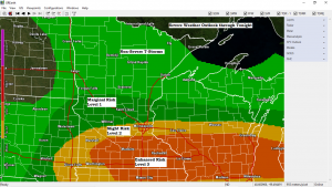
The potential for severe thunderstorms continues through this evening across the southern half of Minnesota into central/southern Wisconsin.
Radar imagery from 2 PM Tuesday already shows a line of thunderstorms from west-central into central Minnesota with movement to the ESE. The air mass downstream of where the thunderstorms are currently located has become quite unstable this afternoon with MLCAPE (mixed layer cape) in the 2000-25000 J/kg range, this combined with other ingredients already in place could lead to some severe weather later this afternoon into this evening over the southern half of Minnesota and central/southern Wisconsin. Large hail, possibly up to 2 inch diameter (bigger than golf balls) and damaging winds are the main severe weather threats today, but there is also a chance for an isolated tornado south of the Twin Cities.
Note: The Northland will not be affected by any of this as all the thunderstorms and severe weather stays off to our south through tonight.

Here’s today’s severe weather setup.
Low pressure over southeastern South Dakota (red L on map) with a warm front (red line on map) and cold front (blue line on map) The low and frontal boundaries will help create lift in the atmosphere, while a jet streak over the Northern Plains (purple outlined area on map) creates further lift and also produces divergence to the SE of said jet streak. This all sets the stage for possible severe weather into this evening from the southern half of Minnesota east into central and southern Wisconsin.
Source: https://www.spc.noaa.gov

Thanks for reading!
Tim
Leave a Reply