Thursday is shaping up to be another real nice late spring day across the Northland with highs ranging from the upper 70s to the lower-middle 80s! Humidity levels will remain tolerable as well with dew points in the 40s and 50s. Winds will be out of the southwest, west or north at 5 to 15 mph.
A sneak peek at Friday and Saturday’s weather features more pleasant conditions in northeast Minnesota and northwest Wisconsin with no rain in the forecast. Highs mid 70s to lower 80s on Friday, turning a bit cooler Saturday with highs in the 60s and 70s, and it will be even cooler near Lake Superior as an easterly wind develops.
Here’s a look at the simulated radar forecast valid from 1 AM Thursday to 7 AM Friday.
A few light showers are possible early Thursday morning across far northern Minnesota, then we may see some showers develop further south late Thursday night/early Friday morning, otherwise expect partly to mostly sunny skies for Thursday.
Source: 18z NAM 3km model 6.3.2020; https://weathermodels.com

Source: 18z NAM 3km model 6.3.2020

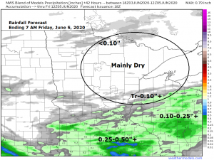
Another round of strong to severe thunderstorms is possible Thursday or Thursday night across the southern half of Minnesota while a few showers and isolated thunderstorms are possible further north across our local area on Thursday.
Source: https://www.pivotalweather.com

It was an active severe weather day on Tuesday from southern Minnesota to southern Wisconsin with numerous reports of damaging winds and hail and at least 3 reports of tornadoes in far southern Minnesota, all centered in Blue Earth County.
Source: https://www.spc.noaa.gov

All eyes will be on Cristobal over the next several days – This system is forecast to become a Tropical Storm late Friday night or Saturday morning as it moves over the western Gulf of Mexico. This system could make landfall early next week somewhere in Louisiana the way it looks now.
Note: It’s possible that the remnants of this tropical system could impact the Ohio Valley and Great Lakes region around the middle of next week, but there is considerable model disagreement next week on the track of Cristobal and also on a trough which will approach from the west. A few computer models phase the trough with the tropical system blowing up a powerful low somewhere from the upper Midwest to Ohio Valley with possible heavy rain and flash flooding, other computer models show less phasing and much less rainfall across the upper Midwest next week. Stay tuned. There is also a chance for a pretty chilly air mass to move into the Northland ~June 11 to 13, possibly cold enough for a patchy frost threat late next week!

Thanks for reading!
Tim
Leave a Reply