There is a chance for a little rain in northeast Minnesota and northwest Wisconsin late tonight/early Friday morning as a rather strong disturbance with a decent amount of lift scoots east out of the Northern Plains tonight, but the air is very dry across the Northland this afternoon with dew points only in the 30s, so although some parts of the area may get a little rain late tonight, I don’t think it’s going to be a whole hell of a lot.
Simulated radar forecast valid from 7 PM Thursday to 7 AM Friday.
Source: 18z NAM 3km model 6.4.2020; https://weathermodels.com

Looking ahead to Friday’s weather
*After an early morning rain threat, the rest of the day Friday looks very nice once again with highs in the 70s. Mostly sunny to partly sunny skies will be seen across the Northland with winds becoming northwest 10 to 20 mph with higher gusts likely.
A look at this weekend’s weather
*A cooler lake breeze develops on Saturday, but more so on Sunday, this is when lakeside temperatures may only be in the 40s and 50s! East winds Saturday 5 to 15 mph, increasing and becoming gusty on Sunday (20-25 mph)
*Saturday looks dry in the Northland, then we could see some showers and thunderstorms in northern Minnesota late Saturday night or Sunday morning as warmer, more humid and unstable air begins to lift north ahead of a warm front and strong area of low pressure which will be over the Northern Rockies.
Rainfall Reports for northeast Minnesota and northwest Wisconsin from Thursday morning, June 4, 2020.
Source: https://www.weather.gov/dlh/
Hibbing, MN: 0.20″
3 E Orr, MN: 0.12″
2 E Celina, MN: 0.11″
12 N Grand Rapids, MN: 0.10″
Kabetogama, MN: 0.10″
International Falls, MN: 0.06″
Cotton, MN: 0.06″
Cook, MN: 0.05″
3 E Wright, MN: 0.04″
Embarrass, MN: 0.03″
Duluth Airport: 0.02″
25 E Ely, MN: 0.02″
Zoomed in view of rainfall totals from Thursday morning in the Twin Ports area.

And a zoomed out view of total rainfall across the Northland from Thursday morning, June 4, 2020.

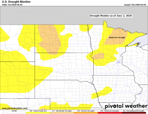
Drought conditions are expanding in the Northland with D1 or moderate drought now covering parts of northern Minnesota (orange shaded area on map) while abnormally dry conditions (yellow) cover much of northeast Minnesota into far northwest Wisconsin.
Here’s how much precipitation has fallen from January 1 to June 3, 2020, and the departure from normal.
Duluth, MN: 5.54″ (-3.73″ below normal)
Brainerd, MN: 4.97″ (-4.09″ below normal)
International Falls, MN: 4.40″ (-2.48″ below normal)
Note: Typically during the summer months will need close to an inch of rain per week to keep drought conditions away, but the pattern that we’ve been in for months is one that features a week or two weeks of mostly dry weather, followed by a precipitation event, which is then followed by several more days of dry weather, if this pattern keeps up this summer, drought conditions could worsen and expand further across the Northland.
Source: https://www.pivotalweather.com; CPC

Tropical system Cristobal is forecast to emerge over the western Gulf of Mexico by early Saturday morning. This system could make landfall over southern Louisiana Sunday night. Cristobal is forecast to remain below hurricane strength.

What happens with the remnants of Cristobal next week is still uncertain.
A trough will develop across the western US this weekend while Cristobal heads north between a ridge to the west, and one to the east. By the early to middle part of next week the trough over the northwest US heads into the upper Midwest which should help pull the remnants of Cristobal to the north, but this is where agreement stops per model data as some models phase the trough approaching from the west with Cristobal resulting in a slow moving strong low pressure system with rain and possible flooding across the upper Midwest in the June 9-11 time frame, while other models show a lot less phasing and lesser amounts of rain next week. Stay tuned.

If the forecast below verifies, then we could put a pretty good dent in our precipitation deficits across the Northland by late next week, but as I’ve said before once a dry pattern locks in, it can be difficult to break out of, so will see what happens, and see how the models trend (drier or wetter) in coming days.
Source: https://lab.weathermodels.com

Thanks for reading!
Tim
Leave a Reply