A few showers or thunderstorms are possible over parts of the Northland late tonight into Monday with the potential for a few more showers or storms Monday night into Tuesday morning, but overall the pattern continues to look dry through mid-week, but if you happen to get underneath a thunderstorm you will get a brief downpour.
Source: https://lab.weathermodels.com

Simulated radar forecast valid from 1 AM Monday to 1 PM Monday.
A few showers or thunderstorms may erupt in parts of our area late tonight or Monday morning as warmer, more humid and unstable air begins to build NE into the upper Midwest. Highs on Monday are forecast to be in the 70s to around 80 degrees with 50s near Lake Superior. Gusty south to southeast winds on Monday at 15 to 35 mph.
Source: 18z NAM 3km model 6.14.2020; https://weathermodels.com

It’s been a very windy day across parts of the Dakotas into western Minnesota with strong south-southeasterly winds of 20 to 40 mph with higher gusts today!
Note: A tight pressure gradient between high pressure over the eastern Great Lakes and low pressure over the Western High Plains is one of the ingredients as to why it’s been so windy today.

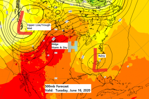
A dry air mass remains over the Northland today, but this will be changing in the next few days.
Monday still won’t be terribly humid as dew points will generally be in the 40s and 50s, but by Tuesday and Wednesday dew points are forecast to climb into the upper 50s to middle 60s so it will be feeling a little muggier at that time.

Looking at a warmer than normal week across the Northland, but lake breezes will continue especially through Wednesday so it will remain cooler for lakeside locations.
Note: Normal highs across the Northland this week are in the lower 70s with normal lows around 50 degrees.

Here’s a look at the Climate Stats so far for June 2020 (thru the 13th)
One big thing that stands out so far this month is how scattered the rains have been, but this really isn’t too unusual for this time of the year. Hibbing has seen over 3″ of rain so far this month, while Duluth has only picked up around a quarter of an inch of rain!
| Brainerd, Minnesota Average Temperature: 68.8 degrees Departure: +6.3 degrees above normal Total Precipitation: 0.59″ Departure: -1.21″ below normal Ashland, Wisconsin Average Temperature: 60.8 degrees Departure: +2.7 degrees above normal Total Precipitation: 0.68″ Departure: -0.97″ below normal Duluth, Minnesota Average Temperature: 60.5 degrees Departure: +3.0 degrees above normal Total Precipitation: 0.27″ Departure: -1.40″ below normal International Falls, Minnesota Average Temperature: 60.4 degrees Departure: +1.8 degrees above normal Total Precipitation: 1.99″ Departure: +0.46″ above normal Hibbing, Minnesota Average Temperature: 59.0 degrees Departure: +1.9 degrees above normal Total Precipitation: 3.41″ Departure: +1.90″ above normal |
Total Rainfall so far for June 2020 (thru the 13th)
Source: https://mrcc.illinois.edu

Total Rainfall and the Percent of Mean for June 2020 (thru the 13th)

Last week’s rainfall totals and the percent of mean

Thanks for reading!
Tim
Leave a Reply