Clouds and some light rain showers helped keep temperatures from getting out of the 60s or lower 70s in northeast Minnesota and northwest Wisconsin today, but temperatures should warm up quite a bit Tuesday and Wednesday, you have the TB guarantee on that! On second thought, maybe I shouldn’t guarantee that, ya never know what Mother Nature has up her sleeve.
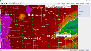
Warm temperatures are out there, and they are not too far away with widespread 80s and a few 90s today from the eastern Dakotas into far western and southern Minnesota, and these warmer temperatures will make it into the Northland on Tuesday along with gusty southerly winds of 10 to around 25 mph. Dew points will creep up a bit as well on Tuesday with dew points in the 56 to 63 degree range.
…Record High Temperatures for June 16th and the year/s they were set…
Note: Brainerd and possibly Duluth may get close to their record high temperatures for June 16th, the other records are probably safe.
Ashland, WI: 98 F (1907)
International Falls, MN: 94 F (1923)
Hibbing, MN: 93 F (1987)
Brainerd, MN: 91 F (1995 and 1933)
Duluth, MN: 88 F (1910 and 1907)


A few showers and thunderstorms are possible tonight across northern Minnesota with an isolated strong to severe thunderstorm possible in the dark green area on map. Note: Portions of northwestern Minnesota are in a mesoscale discussion (pink outlined area on map) but chances that a severe thunderstorm watch are issued are only at 20% per SPC discussion.

Here’s a look at the simulated radar forecast valid from 7 PM Monday to 1 PM Tuesday.
Source: 18z NAM 3km model 6.15.2020; https://weathermodels.com

The pattern is now in rinse and repeat mode!
Take a look at the upper level pattern from today, June 15, 2020.

Now let’s compare today’s pattern with the pattern from May 20th, or just a few weeks ago!
Notice it’s pretty similar with troughs/upper lows (red L) to the west and east with a big ridge (H) in between.

Here’s a chart showing the amount of precipitation which has fallen so far this year in Duluth (green line) while the brown line represents where we should be for precipitation at this time of the year, notice how the trend has been going further and further away from normal, not a good sign!
Duluth is running >5″ below normal for precipitation in 2020 (thru June 15th)
Record Lowest Precipitation for Duluth through June 15th was in 1900 with 3.83″ of precipitation, while the Record Highest Precipitation through June 15th was in 1880 with 21.47″ of precipitation. Note: So far in 2020, Duluth has picked up 5.80″ of precipitation.

Although we could get some rain at times over the next 2 weeks, the overall trend continues to call for below normal precipitation in northeast Minnesota and northwest Wisconsin through the end of this month, what this means is drought conditions could become more widespread and or worsen in parts of the Northland over the next few weeks.
Source: 12z European Ensemble model 6.15.2020; https://weathermodels.com

Thanks for reading!
Tim
Leave a Reply