…Record High Temperatures were broken at Brainerd and Duluth today, June 16th…
Brainerd, Minnesota
New record high for June 16th: 95 degrees; Old record was 91 degrees set in 1933 and again in 1995.
Duluth, Minnesota
New record high for June 16th: 89 degrees; Old record was 88 degrees set in 1907 and again in 1910.
Note: Hibbing and International Falls both had high temperatures today which ranked in the top 5 warmest on record for June 16th.
*First 90 degree or warmer temperature of 2020 occurred today (June 16th) at International Falls, Minnesota with a high of 91 degrees. The average date for first 90 degree or warmer temperature at International Falls is June 25th. Just 2 nights ago, International Falls had a low temperature in the upper 30s!
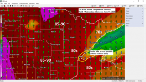
It’s been a very warm day across the Northland, including here in the Twin Ports, but Lake Superior continues to offer some free AC today. Check out the temperature difference in the Twin Ports this afternoon, wild stuff!

90s were widespread today from the Dakotas to Minnesota!

Note: I think the record highs for June 17th are safe…Check them out below.
International Falls, MN: 99 F set in 1995
Hibbing, MN: 97 F set in 1995
Brainerd, MN: 96 F set in 1995
Ashland, WI: 93 F set in 1907
Duluth, MN: 93 F set in 1995
Tonight and Wednesday will be quiet in the Northland, but late Wednesday night brings a chance for some showers and thunderstorms with isolated strong to severe thunderstorms possible across north-central portions of Minnesota. Note: A greater risk for severe weather exists Wednesday evening/overnight in the Slight Risk zone.
Source: https://www.pivotalweather.com; SPC

Here’s a look at the simulated radar forecast valid from 7 PM Wednesday to 7 AM Thursday.
Showers and thunderstorms are forecast to develop across the eastern Dakotas and western Minnesota Wednesday evening, these storms are then forecast to move east into at least western portions of the Northland late Wednesday night into Thursday morning. Note: Another round of showers and thunderstorms are possible across the Northland Thursday afternoon into Thursday night.
Source: 18z NAM 3km model 6.16.2020; https://weathermodels.com

Rainfall totals ranging from a half inch to over an inch are possible in all of northeast Minnesota and most of northwest Wisconsin by early Friday morning. Note: The greatest rain chances in Duluth and Superior look to be from Thursday into Thursday night.
Source: https://lab.weathermodels.com

Thanks for reading!
Tim
Leave a Reply