Showers and thunderstorms are expected at times across the Northland on Thursday. A few of the storms could become strong to severe, especially during the afternoon and evening. The main severe hazard on Thursday is from damaging winds with a lesser chance for hail. All thunderstorms will contain downpours and lightning. Otherwise for Thursday we can expect high temperatures to be in the 70s and 80s with cooler temperatures near Lake Superior.
Note: The last time Duluth picked up more than a quarter inch of rain was on May 26th, 3 weeks ago! June 2020 is running nearly 2″ below normal in rainfall in Duluth, while 2020 is running nearly 5.50″ below normal for precipitation.
Note: No new record high temperatures were broken in the Northland today (June 17th, 2020) but International Falls, Brainerd, Duluth and Hibbing all had high temperatures which ranked in the top 5 warmest on record for June 17th, and International Falls recorded their 2nd consecutive day with a 90 degree or warmer temperature today!

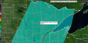
Thursday’s severe risk is in the Marginal category (green box below)

Goes-16 sandwich imagery shows an explosion of severe thunderstorms late this Wednesday afternoon from extreme northwest Minnesota to the eastern Dakotas. Some of this activity, or new development further east may begin to affect western parts of the Northland after Midnight tonight.
Source: https://weather.cod.edu

Thursday’s setup includes a cold front moving east out of western Minnesota. The air mass out ahead of this front will be plenty humid on Thursday with dew points in the 60s to around 70 degrees while PWS or precipitable water increases to around 1.50 to nearly 2.00″, this will increase the chances for torrential downpours where there are thunderstorms.
The overall threat for severe weather for Thursday is rather low, however, and this is due to the potential for lingering cloud cover and showers and thunderstorms through the day which would help keep instability on the low side. Wind shear doesn’t look all that good either with generally 30 knots or less of Effective and 6km Shear per SREF model guidance, and the mid level lapse rates look rather poor too, mostly under 6.5 C/km. Storms that do develop on Thursday will tend to be multicellular (grouped together) but if a cold pool can form, then we may see some damaging wind gusts develop with a line of storms late Thursday afternoon or Thursday evening.
Source: https://www.wpc.ncep.noaa.gov

Here’s a look at the simulated radar forecast valid from 11 PM Wednesday to 7 AM Friday.
Source: 18z NAM 3km model 6.17.2020; https://weathermodels.com

Rainfall totals of a half inch to over an inch are possible on Thursday across most of the Northland with locally higher amounts if you get a few thunderstorms. Lesser amounts of rain are forecast in the tip of the Minnesota Arrowhead, and also over eastern portions of northwest Wisconsin.
Source: https://lab.weathermodels.com

Smoke plumes coming off major wildfires across parts of the western U.S. could affect parts of Minnesota on Thursday. In fact, the cold front approaching from the west combined with SW winds aloft may help carry a plume of thicker smoke to the east with the cold front.
Source: https://rapidrefresh.noaa.gov

…Record Warm Minimum Temperatures broken at Brainerd and International Falls on June 16th, 2020.
Brainerd, Minnesota
New record warm low temperature for June 16th: 71 degrees; old record was 69 degrees set in 2006.
International Falls, Minnesota
New record warm low temperature for June 16th: 68 degrees; old record was 66 degrees set in 2018.
Note: Hibbing, Duluth and Ashland all had low temperatures Tuesday which ranked in the top 5 warmest on record for June 16th.
Thanks for reading!
Tim
Leave a Reply