Warm and dry weather is on the way for Thursday as 80 degree temps return to the Northland! So far this month, 7 days at or above 80 degrees in Duluth (normal for June is 5 days at or above 80 degrees) Note: Most 80 degree days on record for the month of June in Duluth was in 1910 with 17 days with an 80 degree or warmer temperature.
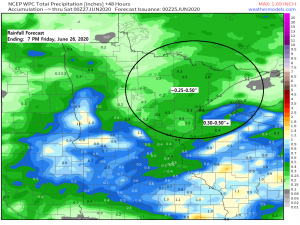
Rain chances return Thursday evening and will continue into Friday, but like we’ve been seeing with past events, rain that occurs should be scattered which means that some areas may miss out, again! On average, we’re looking at a potential for around a quarter to half inch of rain Thursday night and Friday in northeast Minnesota and northwest Wisconsin with higher amounts possible where thunderstorms occur.
As for the thunderstorm potential for Thursday night and Friday – I’m not impressed with this setup. Instability doesn’t look very good, mid level lapse rates are poor, wind shear is lacking with 0-6 km and Effective Bulk Shear generally around 30 knots or less per SREF guidance. Isolated thunderstorms will likely occur Thursday night and Friday, but the potential for strong to severe thunderstorms looks very low at the moment.
Simulated radar forecast valid from 1 PM Thursday to 7 PM Friday.
Source: 18z NAM 3km model 6.24.2020; https://weathermodels.com/

This weekend looks very nice across the Northland with dry weather both Saturday and Sunday with highs in the upper 70s to middle 80s, but an easterly wind is forecast to develop by Sunday which should keep it somewhat cooler near Lake Superior.
Scattered rains! A perfect example of that occurred in Duluth early Tuesday evening where the north/east side of Duluth had a nice, albeit brief downpour with rainfall totals of around 0.05 to 0.10″, well the west and south sides of Duluth only saw a light rain shower/sprinkle, just enough rain to wet the pavement.
Source: https://lab.weathermodels.com/

Rainfall patterns in the summer are so chaotic, some areas get hit with rain over and over again while others get missed.
Over the last 14 days, less than a quarter inch (0.22″) of rain has fallen at the Duluth Airport, normal rainfall total over the last 14 days is 2.04″!
I hate to say it, but these little showers that we’ve been getting in Duluth over the last few weeks won’t get us out of this very dry pattern, the rainfall deficit for the year will continue to increase until we can get a heavy rainfall (something like a 2-4″ rain total in a 24-hour period) and chances we get that type of rainfall in Duluth is quite low. The other way to get out of this dry pattern is for it to rain almost every day for the next month or so, this too looks unlikely. By the way, we’re now running -6.07″ below normal for precipitation in Duluth since January 1st!
Source: https://lab.weathermodels.com/

Big time ridge still being forecast by the EPS and GEFS models for next week, but it is looking increasingly likely that will have a cooler easterly wind near Lake Superior for most of next week with the warmest temperatures away from Lake Superior.
Source: 12z European ensemble model 6.24.2020; https://weathermodels.com/

Lake Superior water temperatures from Wednesday morning, June 24th. Water temps continue to warm over western Lake Superior but remain on the chilly side across central and eastern Lake Superior.
Source: http://www.coastwatch.msu.edu/

Water temps are mostly in the upper 50s to lower 60s today at the head of Lake Superior including in the Twin Ports of Duluth and Superior.

Thanks for reading!
Tim
Leave a Reply