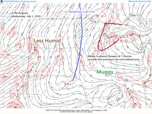
A weakening cold front over western Minnesota late this afternoon along with some convergence ahead of this front combined with a very humid, warm and unstable air mass will be enough to develop a few showers and thunderstorms through this evening across northeast Minnesota and northwest Wisconsin. No severe weather is expected, but downpours and some lightning will occur in a few of the storms. Coverage of this rain should remain isolated, however, so not everyone will get hit by a storm this evening.
We won’t see widespread convection over the Northland late this afternoon into this evening, but at least a few isolated storms are beginning to develop west of Highway 53 and Interstate 35 in northeast Minnesota with movement to the north-northeast.
Radar loop from 3:30 PM to 4:55 PM Wednesday, July 1, 2020.
Source: https://weather.cod.edu/

Simulated radar forecast valid until 7 AM Thursday.
Source: 18z NAM 3km model 7.1.2020; https://weathermodels.com/

Thursday looks dry and very warm across the Northland with highs in the 80s to lower 90s. Friday’s weather looks fairly similar to Thursday’s weather. Note: Both Thursday and Friday may feature slightly cooler temps near Lake Superior, although the lake breeze shouldn’t be as pronounced as it has been the last few days.
Seeing some signs per computer model data for a bit of a pattern change next week. Instead of strong ridging over the Great Lakes into central Canada we may see the ridge shift more into the Plains, if this does happen we should see a belt of stronger winds aloft covering the northern tier of the US next week while embedded disturbances lift up and over the Plains ridge. This kind of setup can lead to lines of severe thunderstorms producing damaging winds/bow echo type storms (red outlined area on map) These storms often develop and track north of where the intense heat develops.
Source: 12z European ensemble model 7.1.2020; https://weathermodels.com/

Here’s a 500mb forecast loop for next week (July 6th-11th, 2020)
Source: 12z European ensemble model 7.1.2020

Thanks for reading!
Tim
Leave a Reply