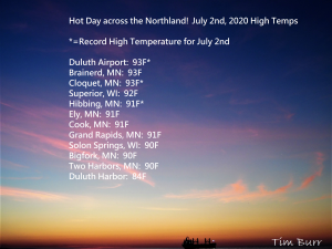
…Record High Temperatures were broken today (July 2nd) at Duluth and Hibbing, Minnesota…
Duluth, Minnesota
New Record High Temperature: 93 degrees set on 7.2.2020, the old record high for July 2nd was 90 degrees set in 1937.
-The high of 93 degrees at Duluth today, July 2nd, 2020 was the first 90 degree or warmer temperature in Duluth since August 11th, 2018.
-And the high of 93 degrees on July 2nd, 2020 was the warmest temperature in Duluth since August 14th, 2015 (High of 93 degrees) and prior to that on July 18th, 2013 Duluth had a high temperature of 94 degrees!
Hibbing, Minnesota
New Record High Temperature: 91 degrees set on 7.2.2020, the old record high for July 2nd was 90 degrees set in 2012 and 1974.
Note: On Wednesday, Hibbing and Brainerd, Minnesota both had a top 5 warmest low temperature on record for July 1st.
*Friday looks like another hot day across the Northland with highs in the upper 80s to lower 90s, but it does look like we may get a slightly stronger lake wind to develop during the afternoon and evening, and if this is the case, temperatures near Lake Superior could drop from the 80s to the 60s later Friday afternoon. Dew points on Friday are forecast to range from the upper 50s to middle 60s so it will remain a bit humid. An isolated shower or thunderstorm is possible on Friday, but the majority of the Northland should stay dry!
*4th of July weather continues to look hot with highs in the middle 80s to lower 90s in northeast Minnesota and northwest Wisconsin. A few isolated showers and thunderstorms are possible on Saturday, but the majority of the Northland should stay dry!
Here are the latest Drought Monitor maps for Minnesota and Wisconsin as of June 30th, 2020.
Moderate Drought or D1 conditions (orange area on map) cover 19% of Minnesota this week, up from 17% a week ago while Abnormally Dry conditions cover 44% of the state (yellow area on map)
Source: https://www.cpc.ncep.noaa.gov/

Drought conditions are also worsening in far northwest Wisconsin with nearly 2% of the state now in Moderate Drought (orange area on map) up from 0% last week while 7% of the state is classified as Abnormally Dry (yellow area on map) which is up from 1% last week.

The map below shows how much additional rain is needed to bring precipitation totals to within a half inch below normal.
The darker orange area which covers all of northeast and northern Minnesota needs 3 to 6 inches of additional rain to get us closer to where we should be at for this time of the year.

I’m still seeing signs in the long range for a wetter weather pattern setting up across the Northland, especially from next week to the end of this forecast run which is July 17th.
Source: 12z European ensemble model 7.2.2020; https://weathermodels.com/

As you can see on the table below, we weren’t doing too bad earlier this year as precipitation totals were running close to normal and even slightly above normal in Duluth from mid-January to early February, but this extremely dry weather pattern really took over in late April and has continued ever since.
There’s only been two quarter inch or greater precipitation events in Duluth since April 29th, and both of those occurred in May (1st and 26th)
The greatest calendar day precipitation in Duluth for June 2020 was just 0.19″ on the 29th.
Precipitation deficit for Duluth since January 1st is sitting at ~7.25″ below normal, or roughly 2 months worth of precipitation below normal.
Accumulated Precipitation table for 2020 at Duluth, Minnesota from January 1st to July 1st. Note: Green line represents the precipitation total for 2020, brown line represents the normal precipitation amount, red line is the driest year thru July 1st while the blue line represents the wettest year thru July 1st.

A few showers and thunderstorms developed this afternoon across southern portions of northwest Wisconsin. These storms moved very slowly so they did produce some brief torrential downpours.

Here’s how this afternoon’s isolated thunderstorms in northern Wisconsin and upper Michigan looked on Goes-16 sandwich satellite imagery. SW upper level winds push the higher clouds NE while storm motions were nearly stationary, or toward the south today, pretty cool!
Source: https://weather.cod.edu/
Loop time: ~2 PM to ~5 PM.

Thanks for reading!
Tim
Leave a Reply