It’s been a bit stormy in parts of northeast Minnesota and northwest Wisconsin today, with one area that has had a few rounds of strong and severe thunderstorms being near Lake Superior. Here’s how today’s storms looked on Goes-16 Sandwich Satellite imagery, this loop goes from around Noon to 6 PM today, July 5, 2020.
Source: https://weather.cod.edu/

Plenty of warm, humid and unstable air over the Northland today, just needed some kind of trigger to cause thunderstorms, and this came in the form of a lake breeze boundary with southwest winds away from Lake Superior while winds closer to the lake were out of the east today.
Source: https://www.spc.noaa.gov/

Note: Duluth Airport has picked up 0.71″ of rain so far today (thru 6 PM) This is the greatest calendar precipitation total Duluth has seen since March 29th when 0.77″ of precipitation fell, and most of that was in the form of snow, and also included some Thundersnow from that winter storm!
24 Hour Rainfall Reports ending at 7 PM Sunday, July 5, 2020
Source: https://mesowest.utah.edu/
Hayward, WI: 1.27″
Duluth Airport: 0.71″
Barnes, WI: 0.70″
Littlefork, MN: 0.37″
Superior Airport: 0.36″
Minong, WI: 0.25″
Washburn, WI: 0.19″
International Falls, MN: 0.16″
Silver Bay, MN: 0.11″
Cook, MN: 0.04″
12 Hour Radar Estimated Rainfall Totals ending 6 PM Sunday, July 5, 2020.

A marginal risk for severe thunderstorms continues tonight in all of northeast Minnesota into far northwest Wisconsin (dark green area on map) Isolated severe storms are possible tonight with hail and gusty winds being the main severe weather threats in the Northland.
Source: https://www.pivotalweather.com/

A marginal risk for severe thunderstorms covers southern portions of the Northland for Monday including east-central and parts of northeast Minnesota and all of northwest Wisconsin (dark green area on map) Isolated severe thunderstorms could develop Monday with the main threats being from hail and gusty winds.

Here’s a look at the simulated radar forecast valid till 7 PM Monday, this is just one models take on how things could play out through Monday evening.
There is a chance that a few rounds of scattered thunderstorms will impact the Northland through late Monday afternoon, and a few of these storms could become strong to severe. Heavy rain and lightning will also occur in any thunderstorm tonight and Monday.
High temps on Monday are forecast to be in the 70s and 80s, and it will remain humid as dew points hold steady in the 60s to lower 70s.
Source: 18z NAM 3km model 7.5.2020; https://weathermodels.com/

…Northland Storm Reports from Sunday, July 5th, 2020…
Source: https://www.weather.gov/dlh/
*6:26 PM: HAIL 0.25 inch. 5 miles south-southwest of Wales, MN (Lake County)
*5:40 PM: THUNDERSTORM WIND DAMAGE. Drummond, WI (Bayfield County) Tree limbs down over roads and power lines.
*5:10 PM: HAIL 0.50 inch. 12 miles west of Drummond, WI (Bayfield County)
*4:56 PM: HAIL 0.88 inch. 1 NNW of Trade River, WI (Burnett County)
*4:52 PM: Heavy Rain 4.00 inch. 5 miles WSW of Ino, WI (Bayfield County)
*4:51 PM: HAIL 0.25 inch. 5 miles WSW of Ino, WI (Bayfield County)
*4:20 PM: HAIL 1.50 inch. 4 miles SE of Island Lake, MN (St. Louis County) Ping Pong Ball sized hail.
*3:20 PM: Heavy Rain 1.25 inch. 11 miles NE of Island Lake, MN (St. Louis County)
*3:15 PM: HAIL 1.00 inch. 3 miles ESE of Island Lake, MN (St. Louis County) Quarter sized hail.
*3:01 PM: HAIL 0.70 inch. 8 SSE of Markham, MN (St. Louis County)
*3:00 PM: Heavy Rain 0.50 inch. 9 miles NNE of Island Lake, MN (St. Louis County)
*3:00 PM: HAIL 0.25 inch. 9 miles NNE of Island Lake, MN (St. Louis County)
*2:36 PM: HAIL 0.25 inch. Brimson, MN (St. Louis County)
A few storm reports from Saturday, July 4th, 2020
Source: https://www.weather.gov/dlh/
*6:16 PM: HAIL 1.25 inch. 10 miles ENE of Cook, MN (St. Louis County) Hail accumulated on deck and was enough to shovel. Largest hail was bigger than quarter…smaller than Golf Ball. Pine cones and small branches fell from trees.
*6:08 PM: HAIL 0.70 inch. 11 miles ENE of Cook, MN (St. Louis County)
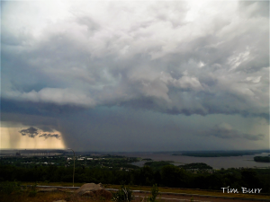
Some pics of today’s storms (July 5th, 2020) Enjoy! All of these photos were taken from Duluth, Minnesota and the Thompson Hill area.


A very warm weather pattern continues across the Northland.
Record High Temperature tied at International Falls, Minnesota on Saturday, July 4th. The high temperature on Saturday was 90 degrees, and this ties the record high temperature of 90 degrees for July 4th which was set in 1948.
Record High Temperature broken at International Falls, Minnesota on Friday, July 3rd. New record for July 3rd: 92 degrees, the old record for July 3rd was 90 degrees set in 1990.
Record High Temperature tied at Duluth, Minnesota on Friday, July 3rd. High temperature was 92 degrees, this ties the record high for July 3rd of 92 degrees which was set in 1990.
Note: Duluth, Minnesota recorded back to back 90 degree days on Thursday and Friday, July 2nd-3rd, 2020. This is the first time since August 13th-15th, 2015 that Duluth has had at least 2 days in a row with a high temperature of 90 degrees or warmer.
It was another warm day in Duluth today, but the temperature failed to reach 90 degrees which means that July 4th, 1881 continues to be the only July 4th on record that had a temperature of at least 90 degrees in Duluth.
On July 3rd, 2020 – Brainerd, Ashland and Hibbing recorded a top 5 warmest high temperature on record for July 3rd.
On July 2nd, 2020 – Duluth and Brainerd recorded a top 5 warmest low temperature on record for July 2nd.
Here are some pictures from July 2nd and 3rd, 2020, enjoy!


Thanks for reading!
Tim
Leave a Reply