Scattered showers and thunderstorms will continue to affect some parts of the Northland this evening, then it looks mainly dry overnight into the day on Tuesday. Highs on Tuesday will mainly be in the 80s, but it looks a little less humid with dew points in the 50s and 60s on Tuesday.
Note: Storms this evening will be capable of producing torrential downpours, lightning, wind gusts to 40 mph and possibly some small hail, and there is also a chance for an isolated severe thunderstorm this evening mainly over northwest Wisconsin.
Simulated Radar Forecast thru 7 PM Tuesday, July 7, 2020.
Source: 18z NAM 3km model 7.6.2020; https://weathermodels.com/

A Slight Risk for Severe Thunderstorms covers all of northwest Wisconsin and far eastern Minnesota through this evening (yellow shaded area on map)
A Marginal Risk for Severe Thunderstorms covers parts of northeast, north-central and east-central Minnesota through this evening (dark green area on map)
Majority of the storms out there today have stayed below severe criteria, but a few storms could become strong to severe through this evening over parts of the Northland with gusty winds and hail being the main threats.
Source: https://www.pivotalweather.com/

Thunderstorms have been moving across northern Minnesota today, here’s how these storms looked on Goes-16 Sandwich Imagery.
Source: https://weather.cod.edu/

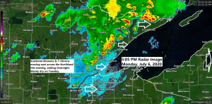
Radar loop from Noon to 4:40 PM CDT, Monday, July 6, 2020.

Widespread quarter to half inch rainfall totals so far today across northern Minnesota with pockets of 1 to 2 inch plus totals. Note: Rain has stayed north of the Twin Ports thru 5 PM today.

Tuesday looks fine during the day, but a few thunderstorms could work their way into the Northland late Tuesday night or Wednesday morning, and a few of those storms could become strong to severe with hail and or gusty winds. Note: A greater risk for severe weather covers parts of Montana and the western Dakotas (Enhanced Risk) on Tuesday.

Number of severe thunderstorm warnings issued in the National Weather Service Duluth, MN forecast area (thru July 6)
Orange line=2020 count
Blue line=2019 count
Source: https://mesonet.agron.iastate.edu/

Some much needed rain fell on Sunday over northeastern Minnesota and northwest Wisconsin, and more rain has been falling today across northern Minnesota.
Source: https://lab.weathermodels.com/

Rainfall Totals from Sunday, July 5, 2020
Source: https://www.weather.gov/dlh/
5 WSW Ino, WI: 4.00″
4 ENE Island Lake, MN: 2.49″
0.5 NW Palmers, MN: 1.85″
Ely, MN: 1.46″
Hayward, WI: 1.36″
8 NE Cook, MN: 1.31″
Duluth Airport: 0.95″
Lutsen, MN: 0.73″
Isabella, MN: 0.70″
1.5 NNW Superior, WI: 0.65″
Local Storm Reports from July 5-6, 2020
Source: https://www.weather.gov/dlh/
3:49 PM 7/6: 1 NE Ely, MN (St. Louis County) Thunderstorm Wind Gust 42 mph.
3:30 PM 7/6: 5 S Tower, MN (St. Louis County) Hail 0.50 inch.
3:21 PM 7/6: 1 SSE Grand Rapids, MN (Itasca County) Thunderstorm Wind Gust 44 mph.
10:31 AM 7/6: 2 ENE Hayward, WI (Sawyer County) Thunderstorm Wind Gust 31 mph.
7:15 PM 7/5: 11 NNW Palmers, MN (St. Louis County) THUNDERSTORM WIND DAMAGE. Trees down along Briar Lake Shoreline.
6:20 PM 7/5: 9 ENE Cook, MN (St. Louis County) HAIL 1.25 inch – Half Dollar sized hail.
5:55 PM 7/5: 4 WNW Namekagon, WI (Bayfield County) THUNDERSTORM WIND DAMAGE. Trees down.
5:40 PM 7/5: 1 W Nett Lake, MN (Koochiching County) Hail 0.25 inch.
4:35 PM 7/5: 6 WSW Ino, WI (Bayfield County) THUNDERSTORM WIND DAMAGE. Trees down on Phantom Lake Rd.
4:15 PM 7/5: 2 NE Island Lake, MN (St. Louis County) THUNDERSTORM WIND DAMAGE. Tree on roadway.
Thanks for reading!
Tim
Leave a Reply