Ingredients appear to be coming together for an active weather day across the Northland on Wednesday, it will be a good day to Stay Weather Aware as multiple waves of thunderstorms (some possibly strong to severe) move across northeast Minnesota and northwest Wisconsin. One round of storms are possible Wednesday morning, with one or two more rounds of storms possible Wednesday afternoon or Wednesday night.
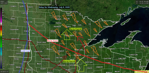
Here’s one models take on how things could play out on Wednesday – Simulated Radar Forecast below runs from 1 AM Wednesday to 7 PM Wednesday, July 8th, 2020.
Source: 12z HRRR model 7.7.2020; https://weathermodels.com/

-Warm and humid air will be over the Northland on Wednesday with highs in the 70s and 80s, and it may even be warmer than that with 90s possible if skies clear enough and for a long enough period of time.
-Dew points on Wednesday are forecast to be in the middle 60s to middle 70s while Precipitable Water increases to between 1.50-2.00″+ So we should have plenty of warm/humid air in place on Wednesday, now will need a trigger, and this looks to come in the form of a warm front and cold front which are forecast to move through the upper Midwest on Wednesday, forcing near those fronts should be sufficient for thunderstorm development.
-CAPE or instability is forecast to be in the 1500-3500 J/kg range on Wednesday while Mid Level Lapse Rates average around 7.0 c/km.
-0-6 KM Wind Shear and Effective Bulk Shear still doesn’t look terribly strong on Wednesday with the SREF model guidance showing about 30-35 knots over the Northland, not very strong, but not weak either, kind of in between.
-Temperatures aloft do look warm, however, with 700mb temperatures forecast to be around +12 or +13C on Wednesday, while the 850mb temps are forecast to be in the +20 to +23C range, temps this warm means a CAP will more than likely spread into the Northland, and if this CAP doesn’t erode, thunderstorms will have a tough time developing later in the day Wednesday.
Note: Severe weather watches and warnings could be issued on Wednesday, and could include some parts of the Northland. Know what county you live in, and the part of that county you live in as warnings typically only cover parts of a county, while a watch will cover a larger portion of an area.
The NAM model guidance (12z run from Tuesday morning) shows potential for supercell thunderstorms across the Northland Wednesday afternoon into Wednesday evening as winds are forecast to be changing direction with height.
Large Hail and Damaging Winds appear to be the greatest severe weather threats across the Northland on Wednesday, but an isolated tornado threat could also develop in northern/northeastern Minnesota Wednesday afternoon/early Wednesday evening.
The image below shows the 850mb to 500mb crossover for late Wednesday afternoon. SSW winds at 850mb, SW at 500mb, not the greatest turning of wind with height at those aforementioned levels, but perhaps just enough to produce an isolated supercell.

This image shows the Surface to 500mb wind crossover for late Wednesday afternoon. SE winds near the surface shifting SW at 500mb. So there appears to be a lot more turning of wind direction with height between near surface winds to 500mb for late Wednesday afternoon.

Thanks for reading!
Tim
Leave a Reply