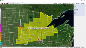
The Storm Prediction Center in Norman, Oklahoma has issued a Severe Thunderstorm Watch which is in effect until Midnight tonight. This watch includes central and northeast Minnesota, far southeast North Dakota, northeast South Dakota, northwest Wisconsin and Lake Superior.
Some cities in the Northland included in this severe thunderstorm watch are…
Bigfork, Grand Rapids, Walker, Cass Lake, Brainerd, Aitkin, Pine City, Hinckley, Moose Lake, Cloquet, Duluth, Hibbing, Ely, Silver Bay, Isabella, Two Harbors, Superior, Washburn, Bayfield, Ashland, Siren, Grantsburg, Minong, Solon Springs, Hayward, Winter, Glidden and Clam Lake.
Primary Threats in the watch area include
Scattered large hail and isolated very large hail events to 2 inches in diameter possible, or quarter to hen egg size hail.
Scattered damaging wind gusts to 70 mph possible
A tornado or two possible
Remember a severe thunderstorm watch means conditions are favorable for severe thunderstorms in and close to the watch area. Persons in these areas should be on the lookout for threatening weather conditions and listen for later statements and possible warnings. Severe thunderstorms can and occasionally do produce tornadoes.
Radar loop ending 5:10 PM CDT, Wednesday, July 8, 2020.
Source: https://weather.cod.edu/
Starting to see a few thunderstorms develop late this afternoon from west-central to northeast Minnesota. Storm coverage should continue to increase over the next few hours.

Here’s a look at two possible scenarios on how things play out tonight.
18z NAM 3km model thru 7 AM Thursday.
Both models show scattered storms this evening, although the HRRR model lingers storms into the overnight while the NAM 3km model shows most of the storms occurring this evening, ending overnight.
Source: https://weathermodels.com/

18z HRRR model thru 7 AM Thursday.

An area of strong thunderstorms developed this afternoon out in the Wright and Cromwell areas in western Carlton County Minnesota, these storms tracked off to the east and moved through Duluth and Superior between about 3:30 and 4 PM today, this area of storms produced a swath of small hail according to radar imagery and also from spotter reports – See below.
3:47 PM: Hail 0.25 inch. 2 miles NE of West Duluth, MN (St. Louis County)
3:31 PM: Hail 0.25 inch. 1 mile N of Cloquet, MN (Carlton County) Slightly larger than pea-sized hail.
3:27 PM: Hail 0.25 inch. Cloquet, MN (Carlton County)

Thunderstorm which moved through Duluth Wednesday afternoon dropped a quick quarter to half inch of rain especially over the southern portion of the city according to radar data.

Thanks for reading!
Tim
Leave a Reply