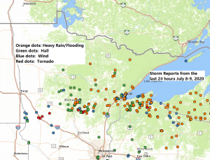
Storm Reports from around the Northland from Wednesday, July 8, 2020 to Thursday, July 9, 2020.
Source: https://www.weather.gov/dlh/
4:00 AM 7/9: THUNDERSTORM WIND DAMAGE. 2 W Duluth, MN (St. Louis County) Tree knocked over.
4:00 AM 7/9: Marine Thunderstorm Wind Gust 47 mph. 1 ESE Duluth, MN
4:00 AM 7/9: HAIL 0.25 inch. 1 NE Duluth, MN (St. Louis County)
3:58 AM 7/9: Marine Thunderstorm Wind Gust 44 mph. 6 SE Duluth, MN
3:54 AM 7/9: Thunderstorm Wind Gust 51 mph. 3 NE Hermantown, MN (St. Louis County)
3:42 AM 7/9: HAIL 0.70″. 1 N Cloquet, MN (Carlton County)
3:40 AM 7/9: HAIL 0.25 inch. 1 WSW Cloquet, MN (Carlton County)
3:20 AM 7/9: THUNDERSTORM WIND DAMAGE. Scanlon, MN (Carlton County) Tree down on metal fencing. Fence mostly intact with the wire portion dislodged and bent at the impact point.
3:06 AM 7/9: Thunderstorm Wind Gust 58 mph. 3 WNW Woodrow, MN (Crow Wing County)
3:00 AM 7/9: HAIL 0.25 inch. 3 ENE Spooner, WI (Washburn County)
2:16 AM 7/9: HAIL 0.75 inch. 6 W Warba, MN (Itasca County)
2:09 AM 7/9: THUNDERSTORM WIND DAMAGE. 1 SW Crosslake, MN (Crow Wing County)
1:42 AM 7/9: HAIL 1.00 inch (Quarter sized hail) 1 SW Lake Shore, MN (Cass County)
1:05 AM 7/9: HAIL 1.00 inch (Quarter sized hail) Backus, MN (Cass County)
1:00 AM 7/9: FLASH FLOOD. 1 NE Iron River, WI (Bayfield County)
12:30 AM 7/9: HAIL 1.00 inch (Quarter sized hail) Pequot Lakes, MN (Crow Wing County)
12:20 AM 7/9: HAIL 0.70″. Kettle River, MN (Carlton County)
11:28 PM 7/8: HAIL 0.88 inch. Whipholt, MN (Cass County)
11:21 PM 7/8: HAIL 1.00 inch (Quarter sized hail) 3 SE Walker, MN (Cass County)
11:10 PM 7/8: FLASH FLOOD. Iron River, WI (Bayfield County) Water over the roadway.
10:40 PM 7/8: HAIL 0.25 inch. Inguadona, MN (Cass County)
10:39 PM 7/8: THUNDERSTORM WIND GUST 60 mph. 3 SW Ashland, WI (Ashland County)
10:35 PM 7/8: FLASH FLOOD. Pequot Lakes, MN (Crow Wing County) Minor street flooding reported on a few streets.
10:20 PM 7/8: HAIL 0.50 inch. 3 SW Crosslake, MN (Crow Wing County)
10:13 PM 7/8: HAIL 0.50 inch. 2 SSW Crosslake, MN (Crow Wing County)
10:13 PM 7/8: THUNDERSTORM WIND DAMAGE. 5 SE Iron River, WI (Bayfield County)
10:08 PM 7/8: HAIL 0.25 inch. Breezy Point, MN (Crow Wing County)
10:05 PM 7/8: HAIL 1.00 inch (Quarter sized hail) Pequot Lakes, MN (Crow Wing County)
10:02 PM 7/8: THUNDERSTORM WIND DAMAGE. Mercer, WI (Iron County)
10:00 PM 7/8: HAIL 0.50 inch. Breezy Point, MN (Crow Wing County)
10:00 PM 7/8: THUNDERSTORM WIND DAMAGE. 5 W Port Wing, WI (Bayfield County) Multiple trees snapped with a reported diameter of 20-30 inches. A few spruce trees were also uprooted.
10:00 PM 7/8: THUNDERSTORM WIND DAMAGE. 6 W Solon Springs, WI (Douglas County) Two trees blown down about 4 to 6 inches in diameter.
9:45 PM 7/8: HAIL 0.50 inch. 2 WNW Nisswa, MN (Cass County)
9:45 PM 7/8: HAIL 1.00 inch (Quarter sized hail) 1 NNE Lake Shore, MN (Cass County)
9:30 PM 7/8: HAIL 0.70 inch. 2 S Rutledge, MN (Pine County)
9:26 PM 7/8: HAIL 0.25 inch. 1 SSE Cloquet, MN (Carlton County)
9:25 PM 7/8: HAIL 0.50 inch. 2 NNE Duluth, MN (St. Louis County)
9:22 PM 7/8: HAIL 0.70 inch. Leader, MN (Cass County) Hail covered the ground.
9:17 PM 7/8: HAIL 0.70 inch. 1 S Esko, MN (Carlton County)
9:12 PM 7/8: HAIL 0.70 inch. Esko, MN (Carlton County)
9:03 PM 7/8: HAIL 0.50 inch. 4 W Mission, MN (Crow Wing County)
9:00 PM 7/8: HAIL 0.88 inch. Esko, MN (Carlton County)
9:00 PM 7/8: HAIL 1.00 inch (Quarter sized hail) Esko, MN (Carlton County)
9:00 PM 7/8: HAIL 0.50 inch. 9 NNE Island Lake, MN (St. Louis County)
8:56 PM 7/8: HAIL 0.70 inch. 1 N Motley, MN (Cass County)
8:52 PM 7/8: HAIL 0.25 inch. 1 N Motley, MN (Cass County)
8:41 PM 7/8: HAIL 0.25 inch. Hermantown, MN (St. Louis County)
8:32 PM 7/8: HAIL 0.88 inch. 6 ESE Deerwood, MN (Aitkin County)
8:30 PM 7/8: THUNDERSTORM WIND DAMAGE. 4 NNW Namekagon, WI (Bayfield County) Birch tree was downed. Approximately 10 to 12 inches in diameter.
8:30 PM 7/8: HAIL 1.00 inch (Quarter sized hail) 5 NE Glen, MN (Aitkin County)
8:14 PM 7/8: FUNNEL CLOUD. 2 SE Mason, WI (Bayfield County) Rain-wrapped funnel cloud reported at the White River Bridge on Highway 63.
8:12 PM 7/8: THUNDERSTORM WIND DAMAGE. 2 SE Malmo, MN (Aitkin County)
8:07 PM 7/8: HAIL 0.25 inch. Bennett, WI (Douglas County)
8:07 PM 7/8: HAIL 1.25 inch (Half Dollar sized hail) 3 NE Garrison, MN (Crow Wing County)
8:07 PM 7/8: HAIL 1.00 inch (Quarter sized hail) 4 W Wealthwood, MN (Aitkin County)
8:00 PM 7/8: TORNADO. 5 W Garrison, MN (Crow Wing County)
7:50 PM 7/8: HAIL 0.25 inch. Ashland, WI (Ashland County)
7:45 PM 7/8: HAIL 1.00 inch (Quarter sized hail) 3 SE Iron River, WI (Bayfield County)
7:43 PM 7/8: HAIL 1.75 inch (Golf Ball sized hail) 1 NW Motley, MN (Cass County)
7:42 PM 7/8: HAIL 0.25 inch. Iron River, WI (Bayfield County)
7:30 PM 7/8: HAIL 0.70 inch. 1 NW Brainerd, MN (Crow Wing County)
7:30 PM 7/8: FUNNEL CLOUD. 5 S Woodrow, MN (Crow Wing County)
7:26 PM 7/8: FUNNEL CLOUD. Brainerd, MN (Crow Wing County) A report of a funnel cloud over the Mississippi River.
7:22 PM 7/8: HAIL 0.88 inch. Solon Springs, WI (Douglas County)
7:22 PM 7/8: TORNADO. 6 NW Pine Center, MN (Crow Wing County)
7:22 PM 7/8: HAIL 0.25 inch. 1 N Brainerd, MN (Crow Wing County)
7:20 PM 7/8: TORNADO. 5 NW Pine Center, MN (Crow Wing County) A roof was blown off a house and a roof was damaged on a detached garage/shed.
7:14 PM 7/8: HAIL 1.00 inch (Quarter sized) 3 E Motley, MN (Cass County)
7:12 PM 7/8: HAIL 0.25 inch. Maple, WI (Douglas County)
7:09 PM 7/8: HAIL 1.00 inch (Quarter sized hail) 1 N Motley, MN (Cass County)
7:04 PM 7/8: HAIL 1.00 inch (Quarter sized hail) 8 SE Brainerd, MN (Crow Wing County)
7:01 PM 7/8: HAIL 0.25 inch. Ely, MN (St. Louis County)
7:00 PM 7/8: HAIL 1.00 inch (Quarter sized) 6 W Solon Springs, WI (Douglas County)
6:53 PM 7/8: HAIL 1.00 inch (Quarter sized hail) 1 N Pillager, MN (Cass County)
6:50 PM 7/8: HAIL 1.75 inch (Golf Ball sized hail) 4 NE Bennett, WI (Douglas County)
6:50 PM 7/8: HAIL 1.00 inch (Quarter sized hail) 6 S Woodrow, MN (Crow Wing County)
6:49 PM 7/8: HAIL 0.25 inch. 7 W Solon Springs, WI (Douglas County)
5:55 PM 7/8: HAIL 0.75 inch. Virginia, MN (St. Louis County)
Radar grab of the tornado warned storm over Garrison, Minnesota, and another tornado warned storm over Brainerd, Minnesota. Quite a hook echo appearance on radar with the tornadic storm over Garrison last evening.

Rotation tracks on the possible tornadoes from Wednesday evening, July 8, 2020 – This first image is the tornado from the Garrison, Minnesota area, east of Brainerd.
Note: The red and blue colors on the images below indicate stronger rotation.

Second image is the rotation track on the tornado warned storm around the Mason, Wisconsin area from Wednesday evening, July 8, 2020.

Goes-16 infrared satellite loop from Wednesday, July 8th, 2020 showing the strong to severe thunderstorms which impacted much of the Northland on Wednesday into early Thursday morning. Incredible stuff!
Note: Those deep red colors on the map indicate cloud top temperatures of around -65 to -70 degrees Celsisus.
Source: https://weather.cod.edu/

A look at the year to date number of severe thunderstorm + tornado warnings issued by the National Weather Service Duluth, Minnesota from 2010 thru 2020 (thru July 9)
So far this year, the Duluth NWS has issued 71 warnings across the Northland, this is the most since 2018 up thru July 9th.
Source: https://mesonet.agron.iastate.edu/

Nearly 70 Severe Thunderstorm Warnings were issued in the NWS Duluth, MN forecast area from Wednesday, July 8th, 2020 thru early Thursday morning, July 9th, 2020.
Breakdown by County below
Cass: 13
Crow Wing: 10
Aitkin: 6
Douglas: 6
Bayfield: 6
St. Louis: 5
Itasca: 4
Carlton: 4
Ashland: 4
Iron: 3
Sawyer: 3
Lake: 2
Price: 2
Washburn: 1
Source: https://mesonet.agron.iastate.edu/

6 Tornado Warnings were issued in the NWS Duluth, MN forecast area on Wednesday, July 8th, 2020.
Breakdown by County below
Crow Wing: 3
Aitkin: 1
Bayfield: 1
Ashland: 1

Rainfall Reports from around the Northland
Source: https://www.weather.gov/dlh/
Event Dates: July 8-9, 2020
1 SSE Lake Nebagamon, WI: 6.70″
1 W Mason, WI: 5.00″
1 E Glen, MN: 4.40″
Deerwood, MN: 4.00″
2.2 S Barnes, WI: 3.95″
Herbster, WI: 3.50″
3 W Bayfield, WI: 3.25″
Oulu, WI: 2.94″
2 S Rutledge, MN: 2.83″
Ashland, WI: 2.80″
Benoit, WI: 2.80″
2 ESE Duluth, MN: 2.49″
Floodwood, MN: 2.33″
8 W Solon Springs, WI: 2.32″
1 S Coleraine, MN: 2.30″
Culver, MN: 2.29″
1 ENE Proctor, MN: 2.25″
4 N Moose Lake, MN: 2.24″
1 S Pleasant Valley, MN: 2.22″
2 NE Duluth, MN: 2.22″
2 N Lester Park, MN: 2.20″
3 WNW Clam Lake, WI: 2.18″
2 NE Cloquet, MN: 2.18″
1 N Hill City, MN: 2.18″
Superior, WI: 2.15″
3 E Wright, MN: 2.12″
7 NNE Mercer, WI: 2.11″
3 NE Duluth, MN: 2.11″
Glidden, WI: 2.10″
Ely, MN: 2.10″
5 SSE South Range, WI: 2.07″
2 N Bigfork, MN: 2.02″
4 ESE Casino, MN: 2.01″
Hill City, MN: 2.00″
Butternut, WI: 1.90″
Morgan Park, MN: 1.79″
Brainerd, MN: 1.76″
Hayward, WI: 1.56″
Two Harbors, MN: 1.31″
25 E Ely, MN: 1.28″
Hurley, WI: 1.25″
Hibbing, MN: 1.25″
Cook, MN: 1.20″
2 S Tower, MN: 1.10″
1 W Washburn, WI: 1.05″
2 E Celina, MN: 0.90″
12 N Grand Rapids, MN: 0.70″
International Falls, MN: 0.33″
Source: https://lab.weathermodels.com/

Thanks for reading!
Tim
Leave a Reply