This post is mostly going to focus on Saturday’s severe weather threat as tonight’s severe weather threat can be found in an earlier post – But just wanted to say that it’s always better to be prepared than not prepared in case severe weather does occur whether it be tonight, Saturday or a few days from now. Have a plan in place just in case! I can’t guarantee that every single city or town in the risk for severe weather tonight and Saturday will see a storm, or two will have any damage (which is always a good thing) Just be prepared as the ingredients for a higher end severe weather event are coming together tonight, and may come together again Saturday afternoon into Saturday evening.
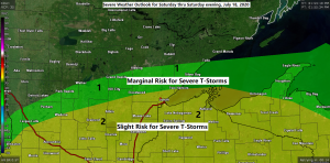
Another round of strong to severe thunderstorms is possible over the Northland Saturday afternoon into Saturday evening. The greatest risk for severe weather on Saturday stretches from east-central Minnesota into all of northwest Wisconsin, or from the Brainerd Lakes to the Twin Ports including all of northwest Wisconsin. Damaging winds, large hail and isolated tornadoes are possible with the storms Saturday afternoon and Saturday evening in the risk area. Note: We could see the slight risk area shift a bit more north or south over the next 12-18 hours, and there is also a chance the slight risk is upgraded to an Enhanced Risk for Saturday. Stay tuned!
A few severe weather tips
-Always have more than one way to get a warning
-Power outages could occur, be ready by charging phones, ensure fuel for generators, chainsaws, etc.
Here’s a look at two possible scenarios on how things could play out for Saturday.
18z HRRR model simulated radar forecast valid 1 PM Saturday to 1 AM Sunday.
Source: https://weathermodels.com/

18z NAM 3km model simulated radar forecast valid 1 PM Saturday to 1 AM Sunday.
This model shows things developing mostly south/east of Duluth late Saturday afternoon, but this model also shows tonight’s bow echo dropping a lot farther south compared to other model guidance, so it makes sense as to why the 3km NAM shows the storms a little farther south on Saturday compared to the HRRR model as the 3km NAM would shove tonight’s cold pool much farther south compared to other guidance.
Not sure which solution to buy into just yet as I could see either one of them playing out, although the 3km NAM seems to be developing storms way too far south on Saturday where a strong CAP should be in place with +13 to +14C 700mb temps forecast to extend from south-central Minnesota into central Wisconsin.

Goes-16 sandwich satellite imagery showing a large thunderstorm complex moving across northern and northeastern North Dakota this afternoon. Loop time 12:06 PM to 4:01 PM CDT, Friday, July 17, 2020.
Source: https://weather.cod.edu/

Radar loop from Friday, July 17, 2020 ending at 4:55 PM CDT.
Severe thunderstorms are moving quickly to the east-southeast across northern and northeast North Dakota and into northwest Minnesota late this afternoon. Note: Already have had a few high wind reports with this line of storms including a wind gust of 101 mph at 3:46 PM today 4 miles NNW of Churchs Ferry, ND along Highway 2.

Tonight’s setup
Note: Thunderstorms, some severe will likely move through most of the Northland tonight, starting in western areas between 7-9 PM, then spreading farther east through the overnight. It’s also possible that we see a few storms develop out ahead of the main line which is approaching from the west-northwest late this afternoon. There is a chance that we see a few storms in Duluth this evening (after 8 PM) but the better chance is after Midnight tonight.
Source: https://www.spc.noaa.gov/

Back tracking to Thursday’s weather for a moment, here are a few additional storm reports from July 16, 2020.
Source: https://www.weather.gov/dlh/
8:49 PM: HEAVY RAIN 1.00″. Little Marais, MN (Lake County) The duration of the rainfall was a little over an hour.
8:25 PM: HEAVY RAIN 1.25″. 1 WSW Two Harbors, MN (Lake County) Rainfall in about an hour.
7:03 PM: FUNNEL CLOUD. 6 N Island Lake, MN (St. Louis County) Funnel cloud near Twin Lakes north of Island and Boulder Lakes.
6:54 PM: FUNNEL CLOUD. 3 NE Silver Bay, MN (Lake County)
5:29 PM: 1.00″ HAIL (Quarter sized) 6 SW Gowan, MN (St. Louis County)
5:05 PM: THUNDERSTORM WIND DAMAGE. 7 SE Deerwood, MN (Aitkin County) Multiple docks were blown into Farm Island Lake, along with a few 8-12 inch diameter trees either uprooted or snapped.
Excessive Heat Warnings and Heat Advisories in effect for Saturday across the Midwest – Heat index values of around 102 to 110 degrees!
Source: https://www.pivotalweather.com/

Thanks for reading!
Tim
Leave a Reply