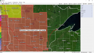
5:57 PM Friday – Storm Prediction Center has issued a PDS or a Particularly Dangerous Situation Severe Thunderstorm Watch for northern and central Minnesota, southeast North Dakota and northern South Dakota effective until 1 AM CDT tonight.
Some cities in the Northland that are included in this watch are…Bigfork, Grand Rapids, Walker, Brainerd, Aitkin, Hill City and McGregor.
Primary Threats include
*Widespread Damaging Winds expected with scattered significant gusts to 90 mph likely.
*Scattered large hail and isolated very large hail to 2.5 inches in diameter or tennis ball sized hail.
*A couple tornadoes possible.
Remember a severe thunderstorm watch means conditions are favorable for severe weather in and close to the watch area. Persons in these areas should be on the lookout for threatening weather conditions and listen for later statements and possible warnings. Severe thunderstorms can and occasionally do produce tornadoes.

Radar image out of Grand Forks, ND shows several lines of severe thunderstorms which are moving east-southeast late this afternoon.

Thanks for reading!
Tim
Leave a Reply